![](/images/other/stat-length.png)
![Randonnée Marche Saint-Floret - Clémensat - Photo](https://media.geolcdn.com/t/1900/400/ext.pjpeg?maxdim=2&url=https%3A%2F%2Fservices.sitytrail.com%2FGeolivesWS%2FDownloadMedia.ashx%3FTrailID%3D102343%26Media%3D2842_1.jpg)
Clémensat
tracegps
Utilisateur
![Longueur](/images/other/stat-length.png)
![Altitude max](https://static1.geolcdn.com/siteimages/upload/files/1508320355ic_sort_altitude_max_24dp.png)
![Dénivelé positif](https://static1.geolcdn.com/siteimages/upload/files/1508320355ic_sort_den_pos_24dp.png)
![Km-Effort](/images/other/stat-length.png)
![Altitude min](https://static1.geolcdn.com/siteimages/upload/files/1508320355ic_sort_altitude_min_24dp.png)
![Dénivelé négatif](https://static1.geolcdn.com/siteimages/upload/files/1508320355ic_sort_den_neg_24dp.png)
![Boucle](https://static1.geolcdn.com/siteimages/upload/files/16400158638029165_repeat_loop_refresh_sync_direction_icon.png)
![Marche](https://static1.geolcdn.com/sitytour/trail-icons/101.png)
1h40
Difficulté : Moyen
![Scannez ce code QR pour ouvrir la randonnée dans l'application SityTrail](https://capi.geolives.com/qq0zvz2zws4bq2lad0pu/sitytour/trails/102343/qr.png?size=200)
Application GPS de randonnée GRATUITE
À propos
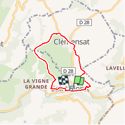
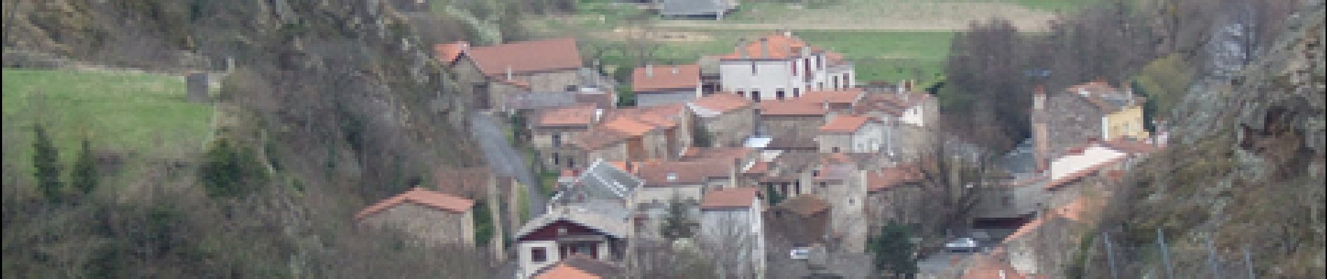
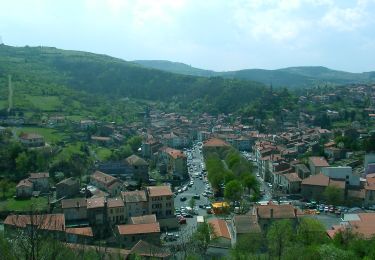
Randonnée Marche de 5,8 km à découvrir à Auvergne-Rhône-Alpes, Puy-de-Dôme, Saint-Floret. Cette randonnée est proposée par tracegps.
Description
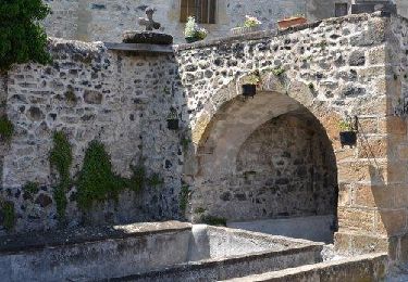
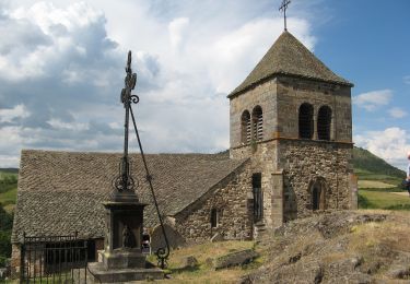
Cette balade sur le versant Nord de La Couze-Pavin cumulée comme celle de la Chaubasse sur le versant Sud, s'aventure sur les plateaux des "chaux" parsemés de pierres arrachées au sol pour améliorer les cultures. Dans le cimetière de l'église du Chastel qui surplombe saint-Floret, des sépultures médiévales rupestres creusées dans le rocher ont été mis au jour. Rares en Auvergne ces cavités anthropomorphiques sont tout à fait remarquables et le site mérite une visite.
Localisation
Commentaires
Randonnées à proximité
![Randonnée Marche Saint-Vincent - St_Vincent_Puy_Lavelle - Photo](https://media.geolcdn.com/t/375/260/a3fc96ef-efb3-4784-a23c-0f44c0b5ca63.jpg&format=jpg&maxdim=2)
![Marche Marche](https://static1.geolcdn.com/sitytour/trail-icons/101.png)
Marche
![](/images/other/stat-length.png)
![](https://static1.geolcdn.com/siteimages/upload/files/16400158638029165_repeat_loop_refresh_sync_direction_icon.png)
![Randonnée Marche Champeix - Champeix_St_Julien - Photo](https://media.geolcdn.com/t/375/260/42c319f4-7a47-48dd-bf0b-2587fad533a9.jpg&format=jpg&maxdim=2)
![Marche Marche](https://static1.geolcdn.com/sitytour/trail-icons/101.png)
Marche
![](/images/other/stat-length.png)
![](https://static1.geolcdn.com/siteimages/upload/files/16400158638029165_repeat_loop_refresh_sync_direction_icon.png)
![Randonnée Marche Montaigut-le-Blanc - Le ravin de Quinsat - Montaigut le Blanc - Photo](https://media.geolcdn.com/t/375/260/ext.jpg?maxdim=2&url=https%3A%2F%2Fservices.sitytrail.com%2FGeolivesWS%2FDownloadMedia.ashx%3FTrailID%3D104453%26Media%3D7707_2.jpg)
![Marche Marche](https://static1.geolcdn.com/sitytour/trail-icons/101.png)
Marche
![](/images/other/stat-length.png)
![](https://static1.geolcdn.com/siteimages/upload/files/16400158638029165_repeat_loop_refresh_sync_direction_icon.png)
![Randonnée A pied Montaigut-le-Blanc - Les caves de Saint-Julien - Photo](https://media.geolcdn.com/t/375/260/cfc5ce46-7f0d-433e-93c8-aa40e374d5a2.jpeg&format=jpg&maxdim=2)
![A pied A pied](https://static1.geolcdn.com/sitytour/trail-icons/100.png)
A pied
![](/images/other/stat-length.png)
![](https://static1.geolcdn.com/siteimages/upload/files/16400158638029165_repeat_loop_refresh_sync_direction_icon.png)
![Randonnée A pied Champeix - La Pierre-Fichade - Photo](https://media.geolcdn.com/t/375/260/d1a5f8f1-78ee-45c6-ac5d-3641d548b5c5.jpeg&format=jpg&maxdim=2)
![A pied A pied](https://static1.geolcdn.com/sitytour/trail-icons/100.png)
A pied
![](/images/other/stat-length.png)
![](https://static1.geolcdn.com/siteimages/upload/files/16400158638029165_repeat_loop_refresh_sync_direction_icon.png)
![Randonnée A pied Montaigut-le-Blanc - Le Tour de la Piniere - Photo](https://media.geolcdn.com/t/375/260/4a1014d7-c9fa-4749-bab6-e03a04c0bb47.jpeg&format=jpg&maxdim=2)
![A pied A pied](https://static1.geolcdn.com/sitytour/trail-icons/100.png)
A pied
![](/images/other/stat-length.png)
![](https://static1.geolcdn.com/siteimages/upload/files/16400158638029165_repeat_loop_refresh_sync_direction_icon.png)
![Randonnée A pied Saint-Floret - La Chaubasse - Photo](https://media.geolcdn.com/t/375/260/768fec42-41d9-4005-9393-314a0342ff62.jpeg&format=jpg&maxdim=2)
![A pied A pied](https://static1.geolcdn.com/sitytour/trail-icons/100.png)
A pied
![](/images/other/stat-length.png)
![](https://static1.geolcdn.com/siteimages/upload/files/16400158638029165_repeat_loop_refresh_sync_direction_icon.png)
![Randonnée A pied Saint-Floret - Clemensat - Photo](https://media.geolcdn.com/t/375/260/768fec42-41d9-4005-9393-314a0342ff62.jpeg&format=jpg&maxdim=2)
![A pied A pied](https://static1.geolcdn.com/sitytour/trail-icons/100.png)
A pied
![](/images/other/stat-length.png)
![](https://static1.geolcdn.com/siteimages/upload/files/16400158638029165_repeat_loop_refresh_sync_direction_icon.png)
![Randonnée A pied Saint-Vincent - Lavelle - Photo](https://media.geolcdn.com/t/375/260/297b1057-563f-4657-92b7-0e66d7544f1c.jpeg&format=jpg&maxdim=2)
![A pied A pied](https://static1.geolcdn.com/sitytour/trail-icons/100.png)
A pied
![](/images/other/stat-length.png)
![](https://static1.geolcdn.com/siteimages/upload/files/16400158638029165_repeat_loop_refresh_sync_direction_icon.png)
randonnée courte mais très belles vue sur St Florent au début et à la fin du circuit.