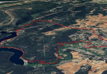
![](/images/other/stat-length.png)
![Randonnée Marche Cotignac - Gros Bessillon - Photo](https://media.geolcdn.com/t/1900/400/ext.pjpeg?maxdim=2&url=https%3A%2F%2Fservices.sitytrail.com%2FGeolivesWS%2FDownloadMedia.ashx%3FTrailID%3D102284%26Media%3D2745_4.jpg)
Gros Bessillon
tracegps
Utilisateur
![Longueur](/images/other/stat-length.png)
![Altitude max](https://static1.geolcdn.com/siteimages/upload/files/1508320355ic_sort_altitude_max_24dp.png)
![Dénivelé positif](https://static1.geolcdn.com/siteimages/upload/files/1508320355ic_sort_den_pos_24dp.png)
![Km-Effort](/images/other/stat-length.png)
![Altitude min](https://static1.geolcdn.com/siteimages/upload/files/1508320355ic_sort_altitude_min_24dp.png)
![Dénivelé négatif](https://static1.geolcdn.com/siteimages/upload/files/1508320355ic_sort_den_neg_24dp.png)
![Boucle](https://static1.geolcdn.com/siteimages/upload/files/16400158638029165_repeat_loop_refresh_sync_direction_icon.png)
![Marche](https://static1.geolcdn.com/sitytour/trail-icons/101.png)
5h00
Difficulté : Difficile
![Scannez ce code QR pour ouvrir la randonnée dans l'application SityTrail](https://capi.geolives.com/qq0zvz2zws4bq2lad0pu/sitytour/trails/102284/qr.png?size=200)
Application GPS de randonnée GRATUITE
À propos
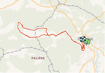
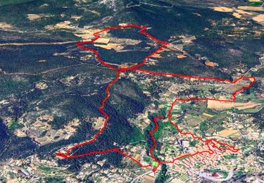
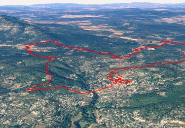
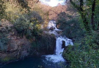
Randonnée Marche de 21 km à découvrir à Provence-Alpes-Côte d'Azur, Var, Cotignac. Cette randonnée est proposée par tracegps.
Description
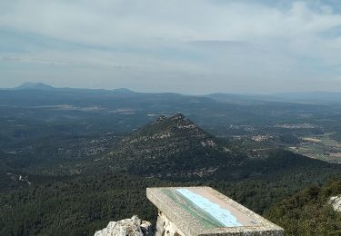
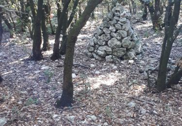
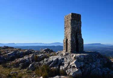
A Cotignac prendre direction Carces pour prendre tout de suite après le pont la route qui monte à ND de Grace afin de garer les voitures. Ensuite piste NW, passer la chapelle ST JOSEPH, prendre la piste S du grand Bessillon jusqu' au carrefour du Jas du Bessillon, ensuite prendre Est une sente qui monte sous une barre rocheuse jusqu' à la tour de surveillance : montée très raide et mettre les mains dans les rochers ( points rouges et cairns) et au sommet: point de vue sur la région et table d' orientation ( mal orientée). On longe Est la clôture et à la stèle des Maquisards descendre S et retrouver la piste de l’aller. Retour au parking
Localisation
Commentaires
Randonnées à proximité
![Randonnée Marche Cotignac - Cotignac - Les chapelles - Habitat Troglodyte - (V2 courte) - Photo](https://media.geolcdn.com/t/375/260/3df5ec25-d552-4f62-91dd-9a69845e3551.jpg&format=jpg&maxdim=2)
![Marche Marche](https://static1.geolcdn.com/sitytour/trail-icons/101.png)
Marche
![](/images/other/stat-length.png)
![](https://static1.geolcdn.com/siteimages/upload/files/16400158638029165_repeat_loop_refresh_sync_direction_icon.png)
![Randonnée Marche Cotignac - Cotignac - Les chapelles - Habitat Troglodyte - (V1 longue) - Photo](https://media.geolcdn.com/t/375/260/f720fb36-9a63-45e5-a4fe-2f41a31767be.jpg&format=jpg&maxdim=2)
![Marche Marche](https://static1.geolcdn.com/sitytour/trail-icons/101.png)
Marche
![](/images/other/stat-length.png)
![](https://static1.geolcdn.com/siteimages/upload/files/16400158638029165_repeat_loop_refresh_sync_direction_icon.png)
![Randonnée Marche Sillans-la-Cascade - Caseneuve - Photo](https://media.geolcdn.com/t/375/260/ext.jpg?maxdim=2&url=https%3A%2F%2Fservices.sitytrail.com%2FGeolivesWS%2FDownloadMedia.ashx%3FTrailID%3D699653%26Media%3D20170105120554.jpg)
![Marche Marche](https://static1.geolcdn.com/sitytour/trail-icons/101.png)
Marche
![](/images/other/stat-length.png)
![](https://static1.geolcdn.com/siteimages/upload/files/16400158638029165_repeat_loop_refresh_sync_direction_icon.png)
![Randonnée Marche Carcès - Chutes du Caramy Lac de Carcès - Photo](https://media.geolcdn.com/t/375/260/510b7d37-063e-46f0-8574-826af0de54c3.jpg&format=jpg&maxdim=2)
![Marche Marche](https://static1.geolcdn.com/sitytour/trail-icons/101.png)
Marche
![](/images/other/stat-length.png)
![](https://static1.geolcdn.com/siteimages/upload/files/16400158638029165_repeat_loop_refresh_sync_direction_icon.png)
![Randonnée Marche Carcès - Village - Cimetière - GR 51 - Les Plaines - Bord du lac - Canal d'irrigation (V2 - plus courte) - Photo](https://media.geolcdn.com/t/375/260/660821b2-598a-4229-b80b-0d7a5b20fc88.jpg&format=jpg&maxdim=2)
![Marche Marche](https://static1.geolcdn.com/sitytour/trail-icons/101.png)
Marche
![](/images/other/stat-length.png)
![](https://static1.geolcdn.com/siteimages/upload/files/16400158638029165_repeat_loop_refresh_sync_direction_icon.png)
![Randonnée Marche Cotignac - Tour du gros Bessillon - Photo](https://media.geolcdn.com/t/375/260/779808d6-cf2d-4575-a137-1a82d1025a08.jpg&format=jpg&maxdim=2)
![Marche Marche](https://static1.geolcdn.com/sitytour/trail-icons/101.png)
Marche
![](/images/other/stat-length.png)
![](https://static1.geolcdn.com/siteimages/upload/files/16400158638029165_repeat_loop_refresh_sync_direction_icon.png)
![Randonnée Marche Cotignac - Gros Bessillon, Cotignac - Photo](https://media.geolcdn.com/t/375/260/a81bddb8-87f5-460d-8429-4f14fe2dbd16.jpg&format=jpg&maxdim=2)
![Marche Marche](https://static1.geolcdn.com/sitytour/trail-icons/101.png)
Marche
![](/images/other/stat-length.png)
![](https://static1.geolcdn.com/siteimages/upload/files/16400158638029165_repeat_loop_refresh_sync_direction_icon.png)
![Marche Marche](https://static1.geolcdn.com/sitytour/trail-icons/101.png)
Marche
![](/images/other/stat-length.png)
![](https://static1.geolcdn.com/siteimages/upload/files/16400158638029165_repeat_loop_refresh_sync_direction_icon.png)
![Randonnée Marche Carcès - CARCES - CASCADES DU CARAMY - Photo](https://media.geolcdn.com/t/375/260/831e1b59-31a1-45ca-a48a-d329418ef9bb.jpg&format=jpg&maxdim=2)
![Marche Marche](https://static1.geolcdn.com/sitytour/trail-icons/101.png)
Marche
![](/images/other/stat-length.png)
![](https://static1.geolcdn.com/siteimages/upload/files/16400158638029165_repeat_loop_refresh_sync_direction_icon.png)
Super : fait ce 08/07/13