![](/images/other/stat-length.png)
![Randonnée V.T.T. Bouvigny-Boyeffles - Autour de la Cuesta - Photo](https://media.geolcdn.com/t/1900/400/ext.pjpeg?maxdim=2&url=https%3A%2F%2Fservices.sitytrail.com%2FGeolivesWS%2FDownloadMedia.ashx%3FTrailID%3D102223%26Media%3D2683_1.jpg)
Autour de la Cuesta
tracegps
Utilisateur
![Longueur](/images/other/stat-length.png)
Longueur
12,2 km
![Altitude max](https://static1.geolcdn.com/siteimages/upload/files/1508320355ic_sort_altitude_max_24dp.png)
Altitude max
194 m
![Dénivelé positif](https://static1.geolcdn.com/siteimages/upload/files/1508320355ic_sort_den_pos_24dp.png)
Dénivelé positif
225 m
![Km-Effort](/images/other/stat-length.png)
Km-Effort
15,2 km
![Altitude min](https://static1.geolcdn.com/siteimages/upload/files/1508320355ic_sort_altitude_min_24dp.png)
Altitude min
113 m
![Dénivelé négatif](https://static1.geolcdn.com/siteimages/upload/files/1508320355ic_sort_den_neg_24dp.png)
Dénivelé négatif
224 m
![Boucle](https://static1.geolcdn.com/siteimages/upload/files/16400158638029165_repeat_loop_refresh_sync_direction_icon.png)
Boucle
Oui
Date de création :
2014-12-10 00:00:00.0
Dernière modification :
2014-12-10 00:00:00.0
![V.T.T.](https://static1.geolcdn.com/sitytour/trail-icons/202.png)
1h00
Difficulté : Moyen
![Scannez ce code QR pour ouvrir la randonnée dans l'application SityTrail](https://capi.geolives.com/qq0zvz2zws4bq2lad0pu/sitytour/trails/102223/qr.png?size=200)
Application GPS de randonnée GRATUITE
À propos
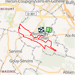
Randonnée V.T.T. de 12,2 km à découvrir à Hauts-de-France, Pas-de-Calais, Bouvigny-Boyeffles. Cette randonnée est proposée par tracegps.
Description
Circuit proposé par Artois Vert, le site tout terrain en Artois. Un parcours d'une douzaine de km dans les collines d'Artois qui fait profiter du relief sur la zone naturelle d'Ablain à Bouvigny.
Localisation
Pays :
France
Région :
Hauts-de-France
Département/Province :
Pas-de-Calais
Commune :
Bouvigny-Boyeffles
Localité :
Unknown
Départ:(Dec)
Départ:(UTM)
477087 ; 5585458 (31U) N.
Commentaires
Randonnées à proximité
![Randonnée Marche Hersin-Coupigny - hersin coupigny 8 km - Photo](https://media.geolcdn.com/t/375/260/ext.jpg?maxdim=2&url=https%3A%2F%2Fstatic1.geolcdn.com%2Fsiteimages%2Fupload%2Ffiles%2F1553511878bg_sport_marche.png)
![Marche Marche](https://static1.geolcdn.com/sitytour/trail-icons/101.png)
hersin coupigny 8 km
Marche
Moyen
(1)
Hersin-Coupigny,
Hauts-de-France,
Pas-de-Calais,
France
![](/images/other/stat-length.png)
7,8 km | 8,8 km-effort
1h 59min
![](https://static1.geolcdn.com/siteimages/upload/files/16400158638029165_repeat_loop_refresh_sync_direction_icon.png)
Oui
![Randonnée Course à pied Aix-Noulette - aix noulette sity guide 25,3 km D530+ - Photo](https://media.geolcdn.com/t/375/260/ext.jpg?maxdim=2&url=https%3A%2F%2Fservices.sitytrail.com%2FGeolivesWS%2FDownloadMedia.ashx%3FTrailID%3D229340%26Media%3Dfix__20131027100347.jpg)
![Course à pied Course à pied](https://static1.geolcdn.com/sitytour/trail-icons/103.png)
aix noulette sity guide 25,3 km D530+
Course à pied
Moyen
Aix-Noulette,
Hauts-de-France,
Pas-de-Calais,
France
![](/images/other/stat-length.png)
23 km | 30 km-effort
2h 45min
![](https://static1.geolcdn.com/siteimages/upload/files/16400158638029165_repeat_loop_refresh_sync_direction_icon.png)
Oui
![Randonnée Marche Souchez - Souchez-Noulette-Lorette-Ablain - Photo](https://media.geolcdn.com/t/375/260/ext.jpg?maxdim=2&url=https%3A%2F%2Fservices.sitytrail.com%2FGeolivesWS%2FDownloadMedia.ashx%3FTrailID%3D173056%26Media%3D14580_6.jpg)
![Marche Marche](https://static1.geolcdn.com/sitytour/trail-icons/101.png)
Souchez-Noulette-Lorette-Ablain
Marche
Facile
Souchez,
Hauts-de-France,
Pas-de-Calais,
France
![](/images/other/stat-length.png)
6,7 km | 8,4 km-effort
1h 45min
![](https://static1.geolcdn.com/siteimages/upload/files/16400158638029165_repeat_loop_refresh_sync_direction_icon.png)
Oui
![Randonnée Marche Cambligneul - Cambigneul - Villers Chatel - Mingoval - Caucourt - Estée Cauchy - Photo](https://media.geolcdn.com/t/375/260/ext.jpg?maxdim=2&url=https%3A%2F%2Fservices.sitytrail.com%2FGeolivesWS%2FDownloadMedia.ashx%3FTrailID%3D107206%26Media%3D12065_4.jpg)
![Marche Marche](https://static1.geolcdn.com/sitytour/trail-icons/101.png)
Cambigneul - Villers Chatel - Mingoval - Caucourt - Estée Cauchy
Marche
Moyen
Cambligneul,
Hauts-de-France,
Pas-de-Calais,
France
![](/images/other/stat-length.png)
9,9 km | 11,1 km-effort
2h 0min
![](https://static1.geolcdn.com/siteimages/upload/files/16400158638029165_repeat_loop_refresh_sync_direction_icon.png)
Oui
![Randonnée Marche Ablain-Saint-Nazaire - lorette août 23 - Photo](https://media.geolcdn.com/t/375/260/d5179cbf-eb3e-488a-9ec7-560d31757a4b.jpg&format=jpg&maxdim=2)
![Marche Marche](https://static1.geolcdn.com/sitytour/trail-icons/101.png)
lorette août 23
Marche
Difficile
Ablain-Saint-Nazaire,
Hauts-de-France,
Pas-de-Calais,
France
![](/images/other/stat-length.png)
11,8 km | 15,6 km-effort
2h 29min
![](https://static1.geolcdn.com/siteimages/upload/files/16400158638029165_repeat_loop_refresh_sync_direction_icon.png)
Non
![Randonnée Marche Ablain-Saint-Nazaire - autour d'Alain Saint nazaire - Photo](https://media.geolcdn.com/t/375/260/7e31f38f-bab6-47c8-ae7b-e7b39fa09888.jpg&format=jpg&maxdim=2)
![Marche Marche](https://static1.geolcdn.com/sitytour/trail-icons/101.png)
autour d'Alain Saint nazaire
Marche
Moyen
Ablain-Saint-Nazaire,
Hauts-de-France,
Pas-de-Calais,
France
![](/images/other/stat-length.png)
8,9 km | 11,1 km-effort
2h 4min
![](https://static1.geolcdn.com/siteimages/upload/files/16400158638029165_repeat_loop_refresh_sync_direction_icon.png)
Oui
![Randonnée Marche Souchez - Lorette et Carency CAF - Photo](https://media.geolcdn.com/t/375/260/ext.jpg?maxdim=2&url=https%3A%2F%2Fservices.sitytrail.com%2FGeolivesWS%2FDownloadMedia.ashx%3FTrailID%3D629786%26Media%3Dfix__20160911110430.jpg)
![Marche Marche](https://static1.geolcdn.com/sitytour/trail-icons/101.png)
Lorette et Carency CAF
Marche
Facile
Souchez,
Hauts-de-France,
Pas-de-Calais,
France
![](/images/other/stat-length.png)
21 km | 25 km-effort
5h 24min
![](https://static1.geolcdn.com/siteimages/upload/files/16400158638029165_repeat_loop_refresh_sync_direction_icon.png)
Oui
![Randonnée Marche Bouvigny-Boyeffles - bouvigny - Photo](https://media.geolcdn.com/t/375/260/ext.jpg?maxdim=2&url=https%3A%2F%2Fservices.sitytrail.com%2FGeolivesWS%2FDownloadMedia.ashx%3FTrailID%3D603655%26Media%3D20160723125030.jpg)
![Marche Marche](https://static1.geolcdn.com/sitytour/trail-icons/101.png)
bouvigny
Marche
Difficile
Bouvigny-Boyeffles,
Hauts-de-France,
Pas-de-Calais,
France
![](/images/other/stat-length.png)
14,2 km | 17,3 km-effort
3h 54min
![](https://static1.geolcdn.com/siteimages/upload/files/16400158638029165_repeat_loop_refresh_sync_direction_icon.png)
Oui
![Randonnée Marche Hersin-Coupigny - Les Cavaliers N°2 à Hersin Coupigny - Photo](https://media.geolcdn.com/t/375/260/ext.jpg?maxdim=2&url=https%3A%2F%2Fservices.sitytrail.com%2FGeolivesWS%2FDownloadMedia.ashx%3FTrailID%3D317788%26Media%3D17108_1.jpg)
![Marche Marche](https://static1.geolcdn.com/sitytour/trail-icons/101.png)
Les Cavaliers N°2 à Hersin Coupigny
Marche
Moyen
Hersin-Coupigny,
Hauts-de-France,
Pas-de-Calais,
France
![](/images/other/stat-length.png)
13,6 km | 15,9 km-effort
3h 15min
![](https://static1.geolcdn.com/siteimages/upload/files/16400158638029165_repeat_loop_refresh_sync_direction_icon.png)
Oui
décevant