![](/images/other/stat-length.png)
![Randonnée V.T.T. Aspres-sur-Buëch - Grande Traversée des PréAlpes à VTT : Col des Tours - La Montagne - Photo](https://media.geolcdn.com/t/1900/400/ext.pjpeg?maxdim=2&url=https%3A%2F%2Fservices.sitytrail.com%2FGeolivesWS%2FDownloadMedia.ashx%3FTrailID%3D102164%26Media%3D2554_2.jpg)
Grande Traversée des PréAlpes à VTT : Col des Tours - La Montagne
tracegps
Utilisateur
![Longueur](/images/other/stat-length.png)
![Altitude max](https://static1.geolcdn.com/siteimages/upload/files/1508320355ic_sort_altitude_max_24dp.png)
![Dénivelé positif](https://static1.geolcdn.com/siteimages/upload/files/1508320355ic_sort_den_pos_24dp.png)
![Km-Effort](/images/other/stat-length.png)
![Altitude min](https://static1.geolcdn.com/siteimages/upload/files/1508320355ic_sort_altitude_min_24dp.png)
![Dénivelé négatif](https://static1.geolcdn.com/siteimages/upload/files/1508320355ic_sort_den_neg_24dp.png)
![Boucle](https://static1.geolcdn.com/siteimages/upload/files/16400158638029165_repeat_loop_refresh_sync_direction_icon.png)
![V.T.T.](https://static1.geolcdn.com/sitytour/trail-icons/202.png)
1h30
Difficulté : Difficile
![Scannez ce code QR pour ouvrir la randonnée dans l'application SityTrail](https://capi.geolives.com/qq0zvz2zws4bq2lad0pu/sitytour/trails/102164/qr.png?size=200)
Application GPS de randonnée GRATUITE
À propos
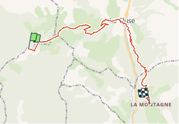
Randonnée V.T.T. de 15 km à découvrir à Provence-Alpes-Côte d'Azur, Hautes-Alpes, Aspres-sur-Buëch. Cette randonnée est proposée par tracegps.
Description
Grande Traversée des Préalpes, les Chemins du Soleil. Parcours officiel labellisé par la Fédération Française de Cyclisme. Parcours Valence – Gap - Sisteron – Tronçon n° 30 Niveau: moyen; bonnes pistes roulantes parsemées de petits raidillons. Mesure de prudence: - après le col de Lauteret, descente technique. - tronçon enneigé tardivement certaines années Consultez toutes les informations sur les hébergements et les services associés sur la fiche du tronçon. Retrouvez cette traversée dans l’indispensable topo Guide Chamina Grande Traversée des Préalpes
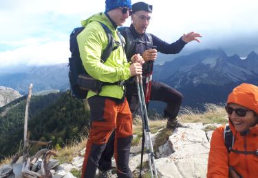
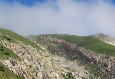
Localisation
Commentaires
Randonnées à proximité
![Randonnée Marche Le Dévoluy - Lauteret-Plate Contier - Photo](https://media.geolcdn.com/t/375/260/1d5aff52-7442-421b-9399-0de1c57b8c1c.jpg&format=jpg&maxdim=2)
![Marche Marche](https://static1.geolcdn.com/sitytour/trail-icons/101.png)
Marche
![](/images/other/stat-length.png)
![](https://static1.geolcdn.com/siteimages/upload/files/16400158638029165_repeat_loop_refresh_sync_direction_icon.png)
![Randonnée Marche Saint-Julien-en-Beauchêne - Chamousset - Photo](https://media.geolcdn.com/t/375/260/3de74403-25a3-49ab-9973-c51b370cf75f.jpg&format=jpg&maxdim=2)
![Marche Marche](https://static1.geolcdn.com/sitytour/trail-icons/101.png)
Marche
![](/images/other/stat-length.png)
![](https://static1.geolcdn.com/siteimages/upload/files/16400158638029165_repeat_loop_refresh_sync_direction_icon.png)
![Randonnée Marche Le Dévoluy - Tête de Garnesier - Photo](https://media.geolcdn.com/t/375/260/36fc5862-5393-4842-9373-0faa5a8d0520.jpg&format=jpg&maxdim=2)
![Marche Marche](https://static1.geolcdn.com/sitytour/trail-icons/101.png)
Marche
![](/images/other/stat-length.png)
![](https://static1.geolcdn.com/siteimages/upload/files/16400158638029165_repeat_loop_refresh_sync_direction_icon.png)
![Randonnée Marche Le Dévoluy - tête de Ganesier - Photo](https://media.geolcdn.com/t/375/260/20ed9398-daa4-443d-a059-baf6f932f729.jpg&format=jpg&maxdim=2)
![Marche Marche](https://static1.geolcdn.com/sitytour/trail-icons/101.png)
Marche
![](/images/other/stat-length.png)
![](https://static1.geolcdn.com/siteimages/upload/files/16400158638029165_repeat_loop_refresh_sync_direction_icon.png)
![Randonnée Marche Lus-la-Croix-Haute - R38 Col des Aiguilles depuis Lus - Photo](https://media.geolcdn.com/t/375/260/ext.jpg?maxdim=2&url=https%3A%2F%2Fservices.sitytrail.com%2FGeolivesWS%2FDownloadMedia.ashx%3FTrailID%3D890897%26Media%3D48008b69-5aeb-41cb-8dd0-25fe44b6160d.jpg)
![Marche Marche](https://static1.geolcdn.com/sitytour/trail-icons/101.png)
Marche
![](/images/other/stat-length.png)
![](https://static1.geolcdn.com/siteimages/upload/files/16400158638029165_repeat_loop_refresh_sync_direction_icon.png)
![Randonnée Marche Saint-Julien-en-Beauchêne - tour des 4 cols - Photo](https://media.geolcdn.com/t/375/260/8527f1e3-99e4-45a7-995d-0319f3af7da7.jpg&format=jpg&maxdim=2)
![Marche Marche](https://static1.geolcdn.com/sitytour/trail-icons/101.png)
Marche
![](/images/other/stat-length.png)
![](https://static1.geolcdn.com/siteimages/upload/files/16400158638029165_repeat_loop_refresh_sync_direction_icon.png)
![Randonnée Marche Le Dévoluy - cabane col des Aiguilles La Jarjatte - Photo](https://media.geolcdn.com/t/375/260/e54a3991-ac4e-4a14-a7c3-660730704058.jpg&format=jpg&maxdim=2)
![Marche Marche](https://static1.geolcdn.com/sitytour/trail-icons/101.png)
Marche
![](/images/other/stat-length.png)
![](https://static1.geolcdn.com/siteimages/upload/files/16400158638029165_repeat_loop_refresh_sync_direction_icon.png)
![Randonnée Marche Lus-la-Croix-Haute - Pic de l'Aigle en circuit - Photo](https://media.geolcdn.com/t/375/260/fb19d13d-3ab9-48a3-a5da-9be1a34f7b83.jpg&format=jpg&maxdim=2)
![Marche Marche](https://static1.geolcdn.com/sitytour/trail-icons/101.png)
Marche
![](/images/other/stat-length.png)
![](https://static1.geolcdn.com/siteimages/upload/files/16400158638029165_repeat_loop_refresh_sync_direction_icon.png)
![Randonnée Marche Saint-Julien-en-Beauchêne - Chamousset (Lus-La-Croix-Haute) - Photo](https://media.geolcdn.com/t/375/260/966b2179-144e-432e-8e8e-7af282119d0a.jpg&format=jpg&maxdim=2)
![Marche Marche](https://static1.geolcdn.com/sitytour/trail-icons/101.png)
Marche
![](/images/other/stat-length.png)
![](https://static1.geolcdn.com/siteimages/upload/files/16400158638029165_repeat_loop_refresh_sync_direction_icon.png)