![](/images/other/stat-length.png)
![Randonnée V.T.T. Sisteron - Grande Traversée des PréAlpes à VTT : Sisteron - Digne les Bains - Photo](https://media.geolcdn.com/t/1900/400/ext.pjpeg?maxdim=2&url=https%3A%2F%2Fservices.sitytrail.com%2FGeolivesWS%2FDownloadMedia.ashx%3FTrailID%3D102151%26Media%3D2541_2.jpg)
Grande Traversée des PréAlpes à VTT : Sisteron - Digne les Bains
tracegps
Utilisateur
![Longueur](/images/other/stat-length.png)
![Altitude max](https://static1.geolcdn.com/siteimages/upload/files/1508320355ic_sort_altitude_max_24dp.png)
![Dénivelé positif](https://static1.geolcdn.com/siteimages/upload/files/1508320355ic_sort_den_pos_24dp.png)
![Km-Effort](/images/other/stat-length.png)
![Altitude min](https://static1.geolcdn.com/siteimages/upload/files/1508320355ic_sort_altitude_min_24dp.png)
![Dénivelé négatif](https://static1.geolcdn.com/siteimages/upload/files/1508320355ic_sort_den_neg_24dp.png)
![Boucle](https://static1.geolcdn.com/siteimages/upload/files/16400158638029165_repeat_loop_refresh_sync_direction_icon.png)
![V.T.T.](https://static1.geolcdn.com/sitytour/trail-icons/202.png)
8h00
Difficulté : Très difficile
![Scannez ce code QR pour ouvrir la randonnée dans l'application SityTrail](https://capi.geolives.com/qq0zvz2zws4bq2lad0pu/sitytour/trails/102151/qr.png?size=200)
Application GPS de randonnée GRATUITE
À propos
Randonnée V.T.T. de 57 km à découvrir à Provence-Alpes-Côte d'Azur, Alpes-de-Haute-Provence, Sisteron. Cette randonnée est proposée par tracegps.
Description
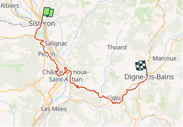
Grande Traversée des Préalpes, les Chemins du Soleil. Parcours officiel labellisé par la Fédération Française de Cyclisme. Parcours Sisteron – Digne les Bains Les 60 nouveaux kilomètres qui permettent de rejoindre Digne-les-Bains sont entièrement équipés d’un balisage conforme aux recommandations nationales de la Fédération Française de Cyclisme et repérable par sa couleur rouge spécifique aux Grandes Traversées à VTT. L’ouverture de ce nouveau tronçon entre dans le cadre du prolongement des itinéraires Chemins du Soleil vers le Nord du massif et la mer Méditerranée afin de créer, à terme, une Grande Traversée intégrale des Préalpes. Consultez toutes les informations sur les hébergements et les services associés sur la fiche du tronçon. Topo Guide Chamina Grande Traversée des Préalpes
Localisation
Commentaires
Randonnées à proximité
![Randonnée Marche Sisteron - SISTERON . CHAMP BRANCOU . LA COLLE . LE MOLLARD O L S - Photo](https://media.geolcdn.com/t/375/260/cecdacbf-083e-4c48-a080-b152844df49c.jpg&format=jpg&maxdim=2)
![Marche Marche](https://static1.geolcdn.com/sitytour/trail-icons/101.png)
Marche
![](/images/other/stat-length.png)
![](https://static1.geolcdn.com/siteimages/upload/files/16400158638029165_repeat_loop_refresh_sync_direction_icon.png)
![Randonnée Marche Sisteron - Le Trou de l'Argent Via Sisteron - Photo](https://media.geolcdn.com/t/375/260/bfa6b4fb-8efb-4bbe-ae9d-f38ed475646a.jpg&format=jpg&maxdim=2)
![Marche Marche](https://static1.geolcdn.com/sitytour/trail-icons/101.png)
Marche
![](/images/other/stat-length.png)
![](https://static1.geolcdn.com/siteimages/upload/files/16400158638029165_repeat_loop_refresh_sync_direction_icon.png)
![Randonnée Marche Entrepierres - SAINT GENIEZ . LE MOURRE DE GACHE PAR LA FONT DE MEGE N - Photo](https://media.geolcdn.com/t/375/260/5d853fdd-5713-4858-a535-57b1bf5db08d.jpg&format=jpg&maxdim=2)
![Marche Marche](https://static1.geolcdn.com/sitytour/trail-icons/101.png)
Marche
![](/images/other/stat-length.png)
![](https://static1.geolcdn.com/siteimages/upload/files/16400158638029165_repeat_loop_refresh_sync_direction_icon.png)
![Randonnée Marche Sisteron - 05 trop argent 02.08.23 - Photo](https://media.geolcdn.com/t/375/260/2f52f635-2a11-4916-a9f5-f3227f3b1529.jpg&format=jpg&maxdim=2)
![Marche Marche](https://static1.geolcdn.com/sitytour/trail-icons/101.png)
Marche
![](/images/other/stat-length.png)
![](https://static1.geolcdn.com/siteimages/upload/files/16400158638029165_repeat_loop_refresh_sync_direction_icon.png)
![Randonnée Marche Sisteron - SISTERON. SUR LA ROUTE DU TEMPS 2. O L M S - Photo](https://media.geolcdn.com/t/375/260/20c8aa54-ba97-4a73-8287-049a48bb92a8.jpg&format=jpg&maxdim=2)
![Marche Marche](https://static1.geolcdn.com/sitytour/trail-icons/101.png)
Marche
![](/images/other/stat-length.png)
![](https://static1.geolcdn.com/siteimages/upload/files/16400158638029165_repeat_loop_refresh_sync_direction_icon.png)
![Randonnée Marche Sisteron - BEVONS crêtes de Chapage o l s m - Photo](https://media.geolcdn.com/t/375/260/06496741-537d-4e32-9a57-13673b07b6c5.jpg&format=jpg&maxdim=2)
![Marche Marche](https://static1.geolcdn.com/sitytour/trail-icons/101.png)
Marche
![](/images/other/stat-length.png)
![](https://static1.geolcdn.com/siteimages/upload/files/16400158638029165_repeat_loop_refresh_sync_direction_icon.png)
![Randonnée Marche Sisteron - Trou de l'argent - Photo](https://media.geolcdn.com/t/375/260/efd53f67-e8d5-4c71-be71-21c3c1bbbb50.jpg&format=jpg&maxdim=2)
![Marche Marche](https://static1.geolcdn.com/sitytour/trail-icons/101.png)
Marche
![](/images/other/stat-length.png)
![](https://static1.geolcdn.com/siteimages/upload/files/16400158638029165_repeat_loop_refresh_sync_direction_icon.png)
![Randonnée Marche Sisteron - Rocher de Baume - Photo](https://media.geolcdn.com/t/375/260/749307ec-c35c-4209-a01b-d1a95a3c6fd6.jpg&format=jpg&maxdim=2)
![Marche Marche](https://static1.geolcdn.com/sitytour/trail-icons/101.png)
Marche
![](/images/other/stat-length.png)
![](https://static1.geolcdn.com/siteimages/upload/files/16400158638029165_repeat_loop_refresh_sync_direction_icon.png)
![Randonnée Marche Sisteron - SISTERON. Le Mollard . Col S Pierre o n - Photo](https://media.geolcdn.com/t/375/260/439b9630-cce8-40a1-b207-cf2467f89777.jpg&format=jpg&maxdim=2)
![Marche Marche](https://static1.geolcdn.com/sitytour/trail-icons/101.png)
Marche
![](/images/other/stat-length.png)
![](https://static1.geolcdn.com/siteimages/upload/files/16400158638029165_repeat_loop_refresh_sync_direction_icon.png)