![](/images/other/stat-length.png)
![Randonnée V.T.T. Nazelles-Négron - Autour de la Loire par le Château de Valmer - Photo](https://media.geolcdn.com/t/1900/400/ext.pjpeg?maxdim=2&url=https%3A%2F%2Fservices.sitytrail.com%2FGeolivesWS%2FDownloadMedia.ashx%3FTrailID%3D102082%26Media%3D2443_2.jpg)
Autour de la Loire par le Château de Valmer
tracegps
Utilisateur
![Longueur](/images/other/stat-length.png)
![Altitude max](https://static1.geolcdn.com/siteimages/upload/files/1508320355ic_sort_altitude_max_24dp.png)
![Dénivelé positif](https://static1.geolcdn.com/siteimages/upload/files/1508320355ic_sort_den_pos_24dp.png)
![Km-Effort](/images/other/stat-length.png)
![Altitude min](https://static1.geolcdn.com/siteimages/upload/files/1508320355ic_sort_altitude_min_24dp.png)
![Dénivelé négatif](https://static1.geolcdn.com/siteimages/upload/files/1508320355ic_sort_den_neg_24dp.png)
![Boucle](https://static1.geolcdn.com/siteimages/upload/files/16400158638029165_repeat_loop_refresh_sync_direction_icon.png)
![V.T.T.](https://static1.geolcdn.com/sitytour/trail-icons/202.png)
3h00
Difficulté : Difficile
![Scannez ce code QR pour ouvrir la randonnée dans l'application SityTrail](https://capi.geolives.com/qq0zvz2zws4bq2lad0pu/sitytour/trails/102082/qr.png?size=200)
Application GPS de randonnée GRATUITE
À propos
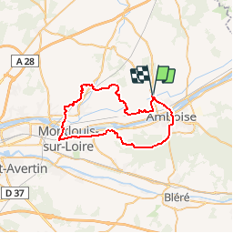
Randonnée V.T.T. de 47 km à découvrir à Centre-Val de Loire, Indre-et-Loire, Nazelles-Négron. Cette randonnée est proposée par tracegps.
Description
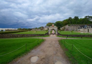
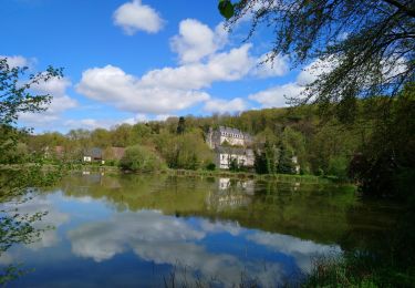
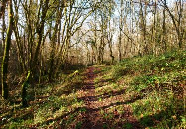
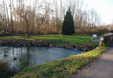
Voici un circuit relativement roulant avec quelques km de route. La première partie chemine au milieu des vignes et passe le long du château de Valmer (slalom sympa entre les arbres). Après avoir traversé la Loire par le pont de chemin de fer (gr) joli point de vue sur la Loire puis passage dans la forêt d'Amboise. Route pour la traversée d'Amboise.
Localisation
Commentaires
Randonnées à proximité
![Randonnée Marche Reugny - Reugny - Zig zag Valmer - 18.5km 315m 4h05 - 2024 05 02 - Photo](https://media.geolcdn.com/t/375/260/5cefbb13-711f-489c-8316-c9b5796f139d.jpg&format=jpg&maxdim=2)
![Marche Marche](https://static1.geolcdn.com/sitytour/trail-icons/101.png)
Marche
![](/images/other/stat-length.png)
![](https://static1.geolcdn.com/siteimages/upload/files/16400158638029165_repeat_loop_refresh_sync_direction_icon.png)
![Randonnée Marche Pocé-sur-Cisse - Pocé-sur-Cisse - Saint-Ouen-les-Vignes - 17km 305m 3h45 (35mn) - 2024 04 10 - Photo](https://media.geolcdn.com/t/375/260/40530b85-1831-4d54-bee3-88999e7b680f.jpg&format=jpg&maxdim=2)
![Marche Marche](https://static1.geolcdn.com/sitytour/trail-icons/101.png)
Marche
![](/images/other/stat-length.png)
![](https://static1.geolcdn.com/siteimages/upload/files/16400158638029165_repeat_loop_refresh_sync_direction_icon.png)
![Randonnée Marche Nazelles-Négron - Nazelles-Négron - Zig zag autour de Nazelles et de Pocé-sur-Cisse - 18.1km 340m 4h05 - 2024 03 24 - Photo](https://media.geolcdn.com/t/375/260/b4c80bca-e974-478d-aff9-0771f417e572.jpg&format=jpg&maxdim=2)
![Marche Marche](https://static1.geolcdn.com/sitytour/trail-icons/101.png)
Marche
![](/images/other/stat-length.png)
![](https://static1.geolcdn.com/siteimages/upload/files/16400158638029165_repeat_loop_refresh_sync_direction_icon.png)
![Randonnée Marche Noizay - Noizay - Zig zag autour des Coteaux à l'est de Noizay - 21.3km 370m 5h00 (40mn) - 2024 03 20 - Photo](https://media.geolcdn.com/t/375/260/6f5cee46-8120-45a7-a457-5ad832f22807.jpg&format=jpg&maxdim=2)
![Marche Marche](https://static1.geolcdn.com/sitytour/trail-icons/101.png)
Marche
![](/images/other/stat-length.png)
![](https://static1.geolcdn.com/siteimages/upload/files/16400158638029165_repeat_loop_refresh_sync_direction_icon.png)
![Randonnée Marche Amboise - Amboise - variante PR Hors des sentiers battus - 13.2km 125m 2h45 - 2023 12 20 - Photo](https://media.geolcdn.com/t/375/260/eaedd70a-7314-4305-8a66-377c6d47d376.jpg&format=jpg&maxdim=2)
![Marche Marche](https://static1.geolcdn.com/sitytour/trail-icons/101.png)
Marche
![](/images/other/stat-length.png)
![](https://static1.geolcdn.com/siteimages/upload/files/16400158638029165_repeat_loop_refresh_sync_direction_icon.png)
![Randonnée Marche Nazelles-Négron - Nazelles-Négron - variante PR Circuit Val Plateau - 10.6km 125m 2h25 (40mn) - 2023 12 20 - Photo](https://media.geolcdn.com/t/375/260/db197c9d-ca81-4840-908b-9a2fe7566a1d.jpg&format=jpg&maxdim=2)
![Marche Marche](https://static1.geolcdn.com/sitytour/trail-icons/101.png)
Marche
![](/images/other/stat-length.png)
![](https://static1.geolcdn.com/siteimages/upload/files/16400158638029165_repeat_loop_refresh_sync_direction_icon.png)
![Randonnée Marche Lussault-sur-Loire - Lussault-sur-Loire - Grille Dorée Pagode de Chanteloup - 15.1km 160m 3h15 - 2023 10 11 - Photo](https://media.geolcdn.com/t/375/260/49886bf8-2556-4f8b-ac9a-489bf75e23bb.jpg&format=jpg&maxdim=2)
![Marche Marche](https://static1.geolcdn.com/sitytour/trail-icons/101.png)
Marche
![](/images/other/stat-length.png)
![](https://static1.geolcdn.com/siteimages/upload/files/16400158638029165_repeat_loop_refresh_sync_direction_icon.png)
![Randonnée Marche Nazelles-Négron - Nazelles-Négron - variante PR Circuit Val Village de Négron - 8.3km 40m 1h50 (40mn) - 2023 10 11 - Photo](https://media.geolcdn.com/t/375/260/a8cef7b4-e79b-4337-9586-e14374732695.jpg&format=jpg&maxdim=2)
![Marche Marche](https://static1.geolcdn.com/sitytour/trail-icons/101.png)
Marche
![](/images/other/stat-length.png)
![](https://static1.geolcdn.com/siteimages/upload/files/16400158638029165_repeat_loop_refresh_sync_direction_icon.png)
![Randonnée Marche Noizay - la Bousserie - Noizay - 14km 100m 3h00 - 2023 02 12 - Photo](https://media.geolcdn.com/t/375/260/e82473dd-70b3-426f-8e44-9d257c621d06.jpg&format=jpg&maxdim=2)
![Marche Marche](https://static1.geolcdn.com/sitytour/trail-icons/101.png)
Marche
![](/images/other/stat-length.png)
![](https://static1.geolcdn.com/siteimages/upload/files/16400158638029165_repeat_loop_refresh_sync_direction_icon.png)