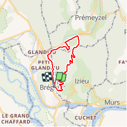
![](/images/other/stat-length.png)
![Randonnée Marche Brégnier-Cordon - La Croix de Saint-Clair et le Pas de la Roche - Photo](https://media.geolcdn.com/t/1900/400/ext.pjpeg?maxdim=2&url=https%3A%2F%2Fservices.sitytrail.com%2FGeolivesWS%2FDownloadMedia.ashx%3FTrailID%3D102069%26Media%3D2428_1.jpg)
La Croix de Saint-Clair et le Pas de la Roche
tracegps
Utilisateur
![Longueur](/images/other/stat-length.png)
![Altitude max](https://static1.geolcdn.com/siteimages/upload/files/1508320355ic_sort_altitude_max_24dp.png)
![Dénivelé positif](https://static1.geolcdn.com/siteimages/upload/files/1508320355ic_sort_den_pos_24dp.png)
![Km-Effort](/images/other/stat-length.png)
![Altitude min](https://static1.geolcdn.com/siteimages/upload/files/1508320355ic_sort_altitude_min_24dp.png)
![Dénivelé négatif](https://static1.geolcdn.com/siteimages/upload/files/1508320355ic_sort_den_neg_24dp.png)
![Boucle](https://static1.geolcdn.com/siteimages/upload/files/16400158638029165_repeat_loop_refresh_sync_direction_icon.png)
![Marche](https://static1.geolcdn.com/sitytour/trail-icons/101.png)
4h00
Difficulté : Moyen
![Scannez ce code QR pour ouvrir la randonnée dans l'application SityTrail](https://capi.geolives.com/qq0zvz2zws4bq2lad0pu/sitytour/trails/102069/qr.png?size=200)
Application GPS de randonnée GRATUITE
À propos
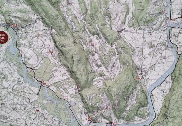
Randonnée Marche de 10,8 km à découvrir à Auvergne-Rhône-Alpes, Ain, Brégnier-Cordon. Cette randonnée est proposée par tracegps.
Description
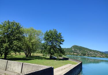
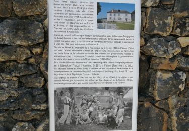
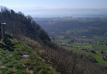
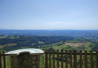
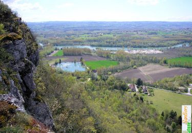
C'est par les marais, au retour du parcours du sentier de l'eau qu'est venue l'idée de ce parcours. Sur le territoire de la commune d'Izieu, la Croix de Saint-Clair qui domine Brégnier-Cordon offre de beaux points de vue sur la plaine du Rhône et de là, le regard pourrait bien se perdre à l'horizon lointain. La randonnée intéressante emprunte des chemins oubliés parfois sauvages qui sont apparemment très peu fréquentés. Mais attention, pour ne pas s'égarer, la carte et la boussole pourraient s'avérer vraiment nécessaire. Description complète sur sentier-nature.com : La Croix de Saint-Clair et le Pas de la Roche
Localisation
Commentaires
Randonnées à proximité
![Randonnée Moteur Arboys-en-Bugey - Rando remise en forme - Photo](https://media.geolcdn.com/t/375/260/ext.jpg?maxdim=2&url=https%3A%2F%2Fstatic1.geolcdn.com%2Fsiteimages%2Fupload%2Ffiles%2F15247431544x4.jpg)
![Moteur Moteur](https://static1.geolcdn.com/sitytour/trail-icons/400.png)
Moteur
![](/images/other/stat-length.png)
![](https://static1.geolcdn.com/siteimages/upload/files/16400158638029165_repeat_loop_refresh_sync_direction_icon.png)
![Randonnée Marche Saint-Genix-les-Villages - 73_gresin_montTournier_18km_630 - Photo](https://media.geolcdn.com/t/375/260/8cc10b7c-be8e-494b-84e7-db8c7dc80b3c.jpg&format=jpg&maxdim=2)
![Marche Marche](https://static1.geolcdn.com/sitytour/trail-icons/101.png)
Marche
![](/images/other/stat-length.png)
![](https://static1.geolcdn.com/siteimages/upload/files/16400158638029165_repeat_loop_refresh_sync_direction_icon.png)
![Randonnée Randonnée équestre Peyrieu - peyrieu Izieu valide cavaliersp - Photo](https://media.geolcdn.com/t/375/260/2c32351f-e06a-4a02-927a-937d3ed0c61b.jpg&format=jpg&maxdim=2)
![Randonnée équestre Randonnée équestre](https://static1.geolcdn.com/sitytour/trail-icons/301.png)
Randonnée équestre
![](/images/other/stat-length.png)
![](https://static1.geolcdn.com/siteimages/upload/files/16400158638029165_repeat_loop_refresh_sync_direction_icon.png)
![Randonnée Randonnée équestre Champagneux - 202206 boucle Gourjux - Photo](https://media.geolcdn.com/t/375/260/c8713771-86f9-46ed-8bc5-7397cec70731.jpg&format=jpg&maxdim=2)
![Randonnée équestre Randonnée équestre](https://static1.geolcdn.com/sitytour/trail-icons/301.png)
Randonnée équestre
![](/images/other/stat-length.png)
![](https://static1.geolcdn.com/siteimages/upload/files/16400158638029165_repeat_loop_refresh_sync_direction_icon.png)
![Randonnée Marche Brégnier-Cordon - Cascade de glandieu, grand Thur en boucle dans l'Ain - Photo](https://media.geolcdn.com/t/375/260/1036fcd4-7da6-4120-94e4-e224fe2ab54b.jpg&format=jpg&maxdim=2)
![Marche Marche](https://static1.geolcdn.com/sitytour/trail-icons/101.png)
Marche
![](/images/other/stat-length.png)
![](https://static1.geolcdn.com/siteimages/upload/files/16400158638029165_repeat_loop_refresh_sync_direction_icon.png)
![Randonnée V.T.C. Brégnier-Cordon - 01-vtt-viarhona-Bregnier-Cordon-2-boucles 30km et 20km - Photo](https://media.geolcdn.com/t/375/260/e2a45222-1cf4-421d-9652-5fba85609478.jpg&format=jpg&maxdim=2)
![V.T.C. V.T.C.](https://static1.geolcdn.com/sitytour/trail-icons/203.png)
V.T.C.
![](/images/other/stat-length.png)
![](https://static1.geolcdn.com/siteimages/upload/files/16400158638029165_repeat_loop_refresh_sync_direction_icon.png)
![Randonnée Marche Saint-Genix-les-Villages - le monts tournier - Photo](https://media.geolcdn.com/t/375/260/73dd6fc7-d7b7-4eb8-83b7-c2dd469235a5.jpg&format=jpg&maxdim=2)
![Marche Marche](https://static1.geolcdn.com/sitytour/trail-icons/101.png)
Marche
![](/images/other/stat-length.png)
![](https://static1.geolcdn.com/siteimages/upload/files/16400158638029165_repeat_loop_refresh_sync_direction_icon.png)
![Randonnée Randonnée équestre Saint-Genix-les-Villages - 201106 boucle StMauriceRotherens - Photo](https://media.geolcdn.com/t/375/260/c9374c5a-470a-410c-8894-565c5f062cd7.jpg&format=jpg&maxdim=2)
![Randonnée équestre Randonnée équestre](https://static1.geolcdn.com/sitytour/trail-icons/301.png)
Randonnée équestre
![](/images/other/stat-length.png)
![](https://static1.geolcdn.com/siteimages/upload/files/16400158638029165_repeat_loop_refresh_sync_direction_icon.png)
![Randonnée Marche Brégnier-Cordon - Tour du Mont de Cordon - Photo](https://media.geolcdn.com/t/375/260/ext.jpg?maxdim=2&url=https%3A%2F%2Fservices.sitytrail.com%2FGeolivesWS%2FDownloadMedia.ashx%3FTrailID%3D102374%26Media%3D2951_1.jpg)
![Marche Marche](https://static1.geolcdn.com/sitytour/trail-icons/101.png)
Marche
![](/images/other/stat-length.png)
![](https://static1.geolcdn.com/siteimages/upload/files/16400158638029165_repeat_loop_refresh_sync_direction_icon.png)