![](/images/other/stat-length.png)
![Randonnée V.T.T. Moëlan-sur-Mer - Espace VTT FFC de Cornouaille - Circuit n°07 - Moëlan sur Mer - Photo](https://media.geolcdn.com/t/1900/400/ext.pjpeg?maxdim=2&url=https%3A%2F%2Fservices.sitytrail.com%2FGeolivesWS%2FDownloadMedia.ashx%3FTrailID%3D102064%26Media%3D2422_2.jpg)
Espace VTT FFC de Cornouaille - Circuit n°07 - Moëlan sur Mer
tracegps
Utilisateur
![Longueur](/images/other/stat-length.png)
![Altitude max](https://static1.geolcdn.com/siteimages/upload/files/1508320355ic_sort_altitude_max_24dp.png)
![Dénivelé positif](https://static1.geolcdn.com/siteimages/upload/files/1508320355ic_sort_den_pos_24dp.png)
![Km-Effort](/images/other/stat-length.png)
![Altitude min](https://static1.geolcdn.com/siteimages/upload/files/1508320355ic_sort_altitude_min_24dp.png)
![Dénivelé négatif](https://static1.geolcdn.com/siteimages/upload/files/1508320355ic_sort_den_neg_24dp.png)
![Boucle](https://static1.geolcdn.com/siteimages/upload/files/16400158638029165_repeat_loop_refresh_sync_direction_icon.png)
![V.T.T.](https://static1.geolcdn.com/sitytour/trail-icons/202.png)
3h00
Difficulté : Difficile
![Scannez ce code QR pour ouvrir la randonnée dans l'application SityTrail](https://capi.geolives.com/qq0zvz2zws4bq2lad0pu/sitytour/trails/102064/qr.png?size=200)
Application GPS de randonnée GRATUITE
À propos
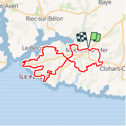
Randonnée V.T.T. de 35 km à découvrir à Bretagne, Finistère, Moëlan-sur-Mer. Cette randonnée est proposée par tracegps.
Description
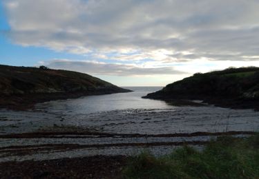
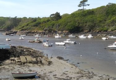
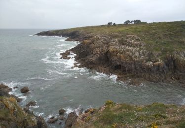
Espace VTT FFC de Cornouaille Circuit labellisé par la Fédération Française de Cyclisme. Moëlan-sur-Mer, petite commune littorale du sud-Finistère. Le port de Brigneau, la plage de Trénez, le site de Kerfany, le port du Bélon, plus aucun de ces lieux-dits ne vous sera inconnu après avoir parcouru ce circuit de 35 km. Vous pourrez même prévoir une halte sur la plage de Kerfany pour vous ressourcer avant de reprendre les petits chemins qui vous offre une vision unique sur l’océan.
Localisation
Commentaires
Randonnées à proximité
![Randonnée Marche Moëlan-sur-Mer - Merrien Doelan cote 11,5 km - Photo](https://media.geolcdn.com/t/375/260/599544b5-7665-42c5-9bba-b91c68249624.jpg&format=jpg&maxdim=2)
![Marche Marche](https://static1.geolcdn.com/sitytour/trail-icons/101.png)
Marche
![](/images/other/stat-length.png)
![](https://static1.geolcdn.com/siteimages/upload/files/16400158638029165_repeat_loop_refresh_sync_direction_icon.png)
![Randonnée Marche Moëlan-sur-Mer - routoirs à lin de Pouldouran - Photo](https://media.geolcdn.com/t/375/260/3361eba2-e966-4e2b-bed4-315e6af4295a.jpg&format=jpg&maxdim=2)
![Marche Marche](https://static1.geolcdn.com/sitytour/trail-icons/101.png)
Marche
![](/images/other/stat-length.png)
![](https://static1.geolcdn.com/siteimages/upload/files/16400158638029165_repeat_loop_refresh_sync_direction_icon.png)
![Randonnée A pied Moëlan-sur-Mer - FR-5 - Photo](https://media.geolcdn.com/t/375/260/7377c7e2-944d-4023-9c3d-895707207e3a.jpeg&format=jpg&maxdim=2)
![A pied A pied](https://static1.geolcdn.com/sitytour/trail-icons/100.png)
![Randonnée Marche Moëlan-sur-Mer - MOELAN Sur MER - Photo](https://media.geolcdn.com/t/375/260/9f5d6a9f-89a4-4a35-9d4e-86b22f763fe6.jpg&format=jpg&maxdim=2)
![Marche Marche](https://static1.geolcdn.com/sitytour/trail-icons/101.png)
Marche
![](/images/other/stat-length.png)
![](https://static1.geolcdn.com/siteimages/upload/files/16400158638029165_repeat_loop_refresh_sync_direction_icon.png)
![Randonnée Marche Moëlan-sur-Mer - MOËLAN SUR MER - Photo](https://media.geolcdn.com/t/375/260/c89b66af-d30f-4599-933a-95fcfe3459c4.jpg&format=jpg&maxdim=2)
![Marche Marche](https://static1.geolcdn.com/sitytour/trail-icons/101.png)
Marche
![](/images/other/stat-length.png)
![](https://static1.geolcdn.com/siteimages/upload/files/16400158638029165_repeat_loop_refresh_sync_direction_icon.png)
![Randonnée Marche Clohars-Carnoët - CLOHARS CARNOËT - Photo](https://media.geolcdn.com/t/375/260/47e82c60-5d8a-4e58-8e2f-70522285a529.jpg&format=jpg&maxdim=2)
![Marche Marche](https://static1.geolcdn.com/sitytour/trail-icons/101.png)
Marche
![](/images/other/stat-length.png)
![](https://static1.geolcdn.com/siteimages/upload/files/16400158638029165_repeat_loop_refresh_sync_direction_icon.png)
![Randonnée Marche Clohars-Carnoët - GR 34 - Photo](https://media.geolcdn.com/t/375/260/ext.jpg?maxdim=2&url=https%3A%2F%2Fservices.sitytrail.com%2FGeolivesWS%2FDownloadMedia.ashx%3FTrailID%3D1128587%26Media%3Dfix__20190330123705.jpg)
![Marche Marche](https://static1.geolcdn.com/sitytour/trail-icons/101.png)
Marche
![](/images/other/stat-length.png)
![](https://static1.geolcdn.com/siteimages/upload/files/16400158638029165_repeat_loop_refresh_sync_direction_icon.png)
![Randonnée Marche Moëlan-sur-Mer - ACLA - Moëslan - 19-05-19 - Photo](https://media.geolcdn.com/t/375/260/ext.jpg?maxdim=2&url=https%3A%2F%2Fstatic1.geolcdn.com%2Fsiteimages%2Fupload%2Ffiles%2F1553511878bg_sport_marche.png)
![Marche Marche](https://static1.geolcdn.com/sitytour/trail-icons/101.png)
Marche
![](/images/other/stat-length.png)
![](https://static1.geolcdn.com/siteimages/upload/files/16400158638029165_repeat_loop_refresh_sync_direction_icon.png)
![Randonnée Marche Clohars-Carnoët - 29-5-Ria de Merrien Rive Gauche_Douelan Rive Droite - Photo](https://media.geolcdn.com/t/375/260/ext.jpg?maxdim=2&url=https%3A%2F%2Fstatic1.geolcdn.com%2Fsiteimages%2Fupload%2Ffiles%2F1553511878bg_sport_marche.png)
![Marche Marche](https://static1.geolcdn.com/sitytour/trail-icons/101.png)
Marche
![](/images/other/stat-length.png)
![](https://static1.geolcdn.com/siteimages/upload/files/16400158638029165_repeat_loop_refresh_sync_direction_icon.png)