![](/images/other/stat-length.png)
![Randonnée V.T.T. Bréziers - Espace VTT FFC de Serre-Ponçon - Durance - Circuit n°14 - Crête de la Scie - Photo](https://media.geolcdn.com/t/1900/400/ext.pjpeg?maxdim=2&url=https%3A%2F%2Fservices.sitytrail.com%2FGeolivesWS%2FDownloadMedia.ashx%3FTrailID%3D102057%26Media%3D2379_1.jpg)
Espace VTT FFC de Serre-Ponçon - Durance - Circuit n°14 - Crête de la Scie
tracegps
Utilisateur
![Longueur](/images/other/stat-length.png)
![Altitude max](https://static1.geolcdn.com/siteimages/upload/files/1508320355ic_sort_altitude_max_24dp.png)
![Dénivelé positif](https://static1.geolcdn.com/siteimages/upload/files/1508320355ic_sort_den_pos_24dp.png)
![Km-Effort](/images/other/stat-length.png)
![Altitude min](https://static1.geolcdn.com/siteimages/upload/files/1508320355ic_sort_altitude_min_24dp.png)
![Dénivelé négatif](https://static1.geolcdn.com/siteimages/upload/files/1508320355ic_sort_den_neg_24dp.png)
![Boucle](https://static1.geolcdn.com/siteimages/upload/files/16400158638029165_repeat_loop_refresh_sync_direction_icon.png)
![V.T.T.](https://static1.geolcdn.com/sitytour/trail-icons/202.png)
1h30
Difficulté : Difficile
![Scannez ce code QR pour ouvrir la randonnée dans l'application SityTrail](https://capi.geolives.com/qq0zvz2zws4bq2lad0pu/sitytour/trails/102057/qr.png?size=200)
Application GPS de randonnée GRATUITE
À propos
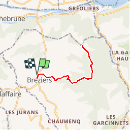
Randonnée V.T.T. de 12,4 km à découvrir à Provence-Alpes-Côte d'Azur, Hautes-Alpes, Bréziers. Cette randonnée est proposée par tracegps.
Description
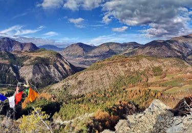
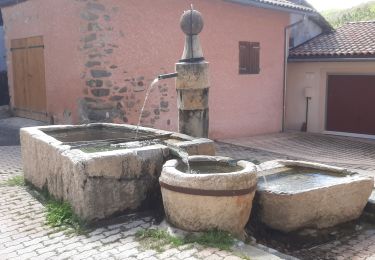
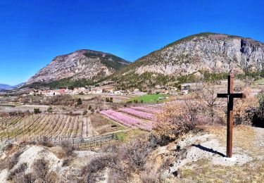
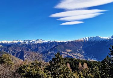
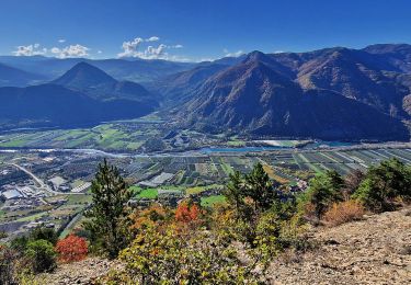
Espace VTT FFC de Serre-Ponçon - Durance Circuit labellisé par la Fédération Française de Cyclisme. Départ à l’entrée de Bréziers (parking du bas). Montée soutenue sur 4 km environ sur piste forestière roulante jusqu’au col à 1281 m d’altitude. Au col, prendre à gauche la piste forestière en belvédère suivant la crête de la Scie. Retour à Bréziers par le même chemin. Superbes points de vue en crête sur la vallée de la Durance, le lac et le barrage de Serre-ponçon. Panorama depuis la montagne de Ceuze à l’ouest, le Pic de Bure, le mont Colombus au nord, le mont Guillaume, le Morgon et le Dormillouse à l’est. . Le village de Bréziers datant du XVII-XVIII ème siècle adossé à un piton rocheux.
Localisation
Commentaires
Randonnées à proximité
![Randonnée Marche Rochebrune - Chapelle Saint-Sixte Via Rochebrune - Photo](https://media.geolcdn.com/t/375/260/0f20d05e-b7e6-44b4-b471-8732af4f1fc9.jpg&format=jpg&maxdim=2)
![Marche Marche](https://static1.geolcdn.com/sitytour/trail-icons/101.png)
Marche
![](/images/other/stat-length.png)
![](https://static1.geolcdn.com/siteimages/upload/files/16400158638029165_repeat_loop_refresh_sync_direction_icon.png)
![Randonnée Marche Gigors - GIGORS Cretes des Barses par variante n - Photo](https://media.geolcdn.com/t/375/260/dbf914d6-b25f-4023-818e-fa0613cb7f91.jpg&format=jpg&maxdim=2)
![Marche Marche](https://static1.geolcdn.com/sitytour/trail-icons/101.png)
Marche
![](/images/other/stat-length.png)
![](https://static1.geolcdn.com/siteimages/upload/files/16400158638029165_repeat_loop_refresh_sync_direction_icon.png)
![Randonnée Marche Turriers - Turriers - Très Pébès - Photo](https://media.geolcdn.com/t/375/260/ext.jpg?maxdim=2&url=https%3A%2F%2Fservices.sitytrail.com%2FGeolivesWS%2FDownloadMedia.ashx%3FTrailID%3D934747%26Media%3D0ff6cfaf-90a9-4052-989f-84a73c7930cd.jpg)
![Marche Marche](https://static1.geolcdn.com/sitytour/trail-icons/101.png)
Marche
![](/images/other/stat-length.png)
![](https://static1.geolcdn.com/siteimages/upload/files/16400158638029165_repeat_loop_refresh_sync_direction_icon.png)
![Randonnée Marche Turriers - Grande Gautière - Photo](https://media.geolcdn.com/t/375/260/ext.jpg?maxdim=2&url=https%3A%2F%2Fstatic1.geolcdn.com%2Fsiteimages%2Fupload%2Ffiles%2F1553511878bg_sport_marche.png)
![Marche Marche](https://static1.geolcdn.com/sitytour/trail-icons/101.png)
Marche
![](/images/other/stat-length.png)
![](https://static1.geolcdn.com/siteimages/upload/files/16400158638029165_repeat_loop_refresh_sync_direction_icon.png)
![Randonnée Marche Remollon - Remollon : Un Trésor Caché de la Vallée de la Durance - Photo](https://media.geolcdn.com/t/375/260/073a624b-9a54-4ca5-a179-7003c0d6383d.jpg&format=jpg&maxdim=2)
![Marche Marche](https://static1.geolcdn.com/sitytour/trail-icons/101.png)
Marche
![](/images/other/stat-length.png)
![](https://static1.geolcdn.com/siteimages/upload/files/16400158638029165_repeat_loop_refresh_sync_direction_icon.png)
![Randonnée Marche Turriers - Grande Gautière et Pointe d'Eyrolle - Photo](https://media.geolcdn.com/t/375/260/6e425574-af27-4f46-bb96-fdf0de28bd88.jpg&format=jpg&maxdim=2)
![Marche Marche](https://static1.geolcdn.com/sitytour/trail-icons/101.png)
Marche
![](/images/other/stat-length.png)
![](https://static1.geolcdn.com/siteimages/upload/files/16400158638029165_repeat_loop_refresh_sync_direction_icon.png)
![Randonnée Marche Espinasses - Salle de bal des Demoiselles Coiffées via Serre Giraud - Photo](https://media.geolcdn.com/t/375/260/308e4b93-b724-42e4-abd4-cc3772156253.jpg&format=jpg&maxdim=2)
![Marche Marche](https://static1.geolcdn.com/sitytour/trail-icons/101.png)
Marche
![](/images/other/stat-length.png)
![](https://static1.geolcdn.com/siteimages/upload/files/16400158638029165_repeat_loop_refresh_sync_direction_icon.png)
![Randonnée Marche Espinasses - Les Demoiselles Coiffées d'Espinasses Théus et Remollon - Photo](https://media.geolcdn.com/t/375/260/1af52faf-437c-42bd-b3af-b635ea9a33d1.jpg&format=jpg&maxdim=2)
![Marche Marche](https://static1.geolcdn.com/sitytour/trail-icons/101.png)
Marche
![](/images/other/stat-length.png)
![](https://static1.geolcdn.com/siteimages/upload/files/16400158638029165_repeat_loop_refresh_sync_direction_icon.png)
![Randonnée Marche Remollon - Des Demoiselles Coiffées aux balcons de Remollon - Photo](https://media.geolcdn.com/t/375/260/2094a0e8-535c-4f81-bf59-f1f898a15092.jpg&format=jpg&maxdim=2)
![Marche Marche](https://static1.geolcdn.com/sitytour/trail-icons/101.png)
Marche
![](/images/other/stat-length.png)
![](https://static1.geolcdn.com/siteimages/upload/files/16400158638029165_repeat_loop_refresh_sync_direction_icon.png)