![](/images/other/stat-length.png)
![Randonnée V.T.T. Chorges - Espace VTT FFC des Vallées du Gapençais - Circuit n°02 - Le Bourget - Photo](https://media.geolcdn.com/t/1900/400/ext.pjpeg?maxdim=2&url=https%3A%2F%2Fservices.sitytrail.com%2FGeolivesWS%2FDownloadMedia.ashx%3FTrailID%3D102045%26Media%3D2367_1.jpg)
Espace VTT FFC des Vallées du Gapençais - Circuit n°02 - Le Bourget
tracegps
Utilisateur
![Longueur](/images/other/stat-length.png)
![Altitude max](https://static1.geolcdn.com/siteimages/upload/files/1508320355ic_sort_altitude_max_24dp.png)
![Dénivelé positif](https://static1.geolcdn.com/siteimages/upload/files/1508320355ic_sort_den_pos_24dp.png)
![Km-Effort](/images/other/stat-length.png)
![Altitude min](https://static1.geolcdn.com/siteimages/upload/files/1508320355ic_sort_altitude_min_24dp.png)
![Dénivelé négatif](https://static1.geolcdn.com/siteimages/upload/files/1508320355ic_sort_den_neg_24dp.png)
![Boucle](https://static1.geolcdn.com/siteimages/upload/files/16400158638029165_repeat_loop_refresh_sync_direction_icon.png)
![V.T.T.](https://static1.geolcdn.com/sitytour/trail-icons/202.png)
1h00
Difficulté : Moyen
![Scannez ce code QR pour ouvrir la randonnée dans l'application SityTrail](https://capi.geolives.com/qq0zvz2zws4bq2lad0pu/sitytour/trails/102045/qr.png?size=200)
Application GPS de randonnée GRATUITE
À propos
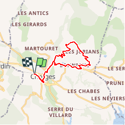
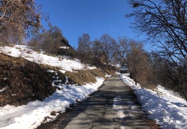
Randonnée V.T.T. de 12,4 km à découvrir à Provence-Alpes-Côte d'Azur, Hautes-Alpes, Chorges. Cette randonnée est proposée par tracegps.
Description
Espace VTT FFC des Vallées du Gapençais Circuit labellisé par la Fédération Française de Cyclisme. Départ à coté du supermarché de Chorges, près du passage à niveau de la Gare SNCF. Circuit en boucle au nord-est de Chorges en majeure partie sur route goudronnée. Circuit permettant une bonne découverte des alentours de Chorges, de la campagne Caturige et du hameau du Bourget. Belle vue panoramique sur Chorges, le lac de Serre-Ponçon et le massif du Morgon.
Localisation
Commentaires
Randonnées à proximité
![Randonnée Marche Chorges - Chanteloube et lac de Serre Ponçon - Photo](https://media.geolcdn.com/t/375/260/ext.jpg?maxdim=2&url=https%3A%2F%2Fservices.sitytrail.com%2FGeolivesWS%2FDownloadMedia.ashx%3FTrailID%3D337864%26Media%3Dfix__20140822114842.jpg)
![Marche Marche](https://static1.geolcdn.com/sitytour/trail-icons/101.png)
Marche
![](/images/other/stat-length.png)
![](https://static1.geolcdn.com/siteimages/upload/files/16400158638029165_repeat_loop_refresh_sync_direction_icon.png)
![Randonnée Marche Chorges - clôt c l'avais sur fein - Photo](https://media.geolcdn.com/t/375/260/ext.jpg?maxdim=2&url=https%3A%2F%2Fservices.sitytrail.com%2FGeolivesWS%2FDownloadMedia.ashx%3FTrailID%3D306998%26Media%3Dfix__20140529172433.jpg)
![Marche Marche](https://static1.geolcdn.com/sitytour/trail-icons/101.png)
Marche
![](/images/other/stat-length.png)
![](https://static1.geolcdn.com/siteimages/upload/files/16400158638029165_repeat_loop_refresh_sync_direction_icon.png)
![Randonnée Marche Chorges - Les Parias et la Pousterle par le col de Chorges - Photo](https://media.geolcdn.com/t/375/260/8b1f1fa4-aaef-4c81-bd3d-65cfa8c4cbf8.jpg&format=jpg&maxdim=2)
![Marche Marche](https://static1.geolcdn.com/sitytour/trail-icons/101.png)
Marche
![](/images/other/stat-length.png)
![](https://static1.geolcdn.com/siteimages/upload/files/16400158638029165_repeat_loop_refresh_sync_direction_icon.png)
![Randonnée Marche Chorges - Montagne du Ruban - Photo](https://media.geolcdn.com/t/375/260/ext.jpg?maxdim=2&url=https%3A%2F%2Fstatic1.geolcdn.com%2Fsiteimages%2Fupload%2Ffiles%2F1553511878bg_sport_marche.png)
![Marche Marche](https://static1.geolcdn.com/sitytour/trail-icons/101.png)
Marche
![](/images/other/stat-length.png)
![](https://static1.geolcdn.com/siteimages/upload/files/16400158638029165_repeat_loop_refresh_sync_direction_icon.png)
![Randonnée Marche Chorges - De la baie de Chanteloube à celle de Saint-Michel - Retour par le Belvédère des Curattes - Photo](https://media.geolcdn.com/t/375/260/30a4afde-c6d7-4d24-9e6c-05905d1a1dbf.jpg&format=jpg&maxdim=2)
![Marche Marche](https://static1.geolcdn.com/sitytour/trail-icons/101.png)
Marche
![](/images/other/stat-length.png)
![](https://static1.geolcdn.com/siteimages/upload/files/16400158638029165_repeat_loop_refresh_sync_direction_icon.png)
![Randonnée Marche Prunières - Trou de pancrace - Serre du mouton et griffes du Lion rose de Salados - Photo](https://media.geolcdn.com/t/375/260/9d97d252-9ee1-4c2d-aad4-6eef70e11633.jpg&format=jpg&maxdim=2)
![Marche Marche](https://static1.geolcdn.com/sitytour/trail-icons/101.png)
Marche
![](/images/other/stat-length.png)
![](https://static1.geolcdn.com/siteimages/upload/files/16400158638029165_repeat_loop_refresh_sync_direction_icon.png)
![Randonnée Marche Chorges - Clôt Clavary 3.9.23 - Photo](https://media.geolcdn.com/t/375/260/e339989a-4af8-4e0a-b588-3657ae86e079.jpg&format=jpg&maxdim=2)
![Marche Marche](https://static1.geolcdn.com/sitytour/trail-icons/101.png)
Marche
![](/images/other/stat-length.png)
![](https://static1.geolcdn.com/siteimages/upload/files/16400158638029165_repeat_loop_refresh_sync_direction_icon.png)
![Randonnée Randonnée équestre Prunières - Le pomeyret avec Ziton - Photo](https://media.geolcdn.com/t/375/260/9e10b878-d3a3-48c5-bb28-52b76372bd5f.jpg&format=jpg&maxdim=2)
![Randonnée équestre Randonnée équestre](https://static1.geolcdn.com/sitytour/trail-icons/301.png)
Randonnée équestre
![](/images/other/stat-length.png)
![](https://static1.geolcdn.com/siteimages/upload/files/16400158638029165_repeat_loop_refresh_sync_direction_icon.png)
![Randonnée Marche Chorges - CHORGES camping clé des champs Cantheloube retour par le nord - Photo](https://media.geolcdn.com/t/375/260/8849e2d3-f82e-42e8-83d7-b7222deacd86.jpg&format=jpg&maxdim=2)
![Marche Marche](https://static1.geolcdn.com/sitytour/trail-icons/101.png)
Marche
![](/images/other/stat-length.png)
![](https://static1.geolcdn.com/siteimages/upload/files/16400158638029165_repeat_loop_refresh_sync_direction_icon.png)