![](/images/other/stat-length.png)
![Randonnée V.T.T. Orcival - Roches Tuilière et Sanadoire - Photo](https://media.geolcdn.com/t/1900/400/ext.pjpeg?maxdim=2&url=https%3A%2F%2Fservices.sitytrail.com%2FGeolivesWS%2FDownloadMedia.ashx%3FTrailID%3D101744%26Media%3D1991_4.jpg)
Roches Tuilière et Sanadoire
tracegps
Utilisateur
![Longueur](/images/other/stat-length.png)
![Altitude max](https://static1.geolcdn.com/siteimages/upload/files/1508320355ic_sort_altitude_max_24dp.png)
![Dénivelé positif](https://static1.geolcdn.com/siteimages/upload/files/1508320355ic_sort_den_pos_24dp.png)
![Km-Effort](/images/other/stat-length.png)
![Altitude min](https://static1.geolcdn.com/siteimages/upload/files/1508320355ic_sort_altitude_min_24dp.png)
![Dénivelé négatif](https://static1.geolcdn.com/siteimages/upload/files/1508320355ic_sort_den_neg_24dp.png)
![Boucle](https://static1.geolcdn.com/siteimages/upload/files/16400158638029165_repeat_loop_refresh_sync_direction_icon.png)
![V.T.T.](https://static1.geolcdn.com/sitytour/trail-icons/202.png)
1h00
Difficulté : Difficile
![Scannez ce code QR pour ouvrir la randonnée dans l'application SityTrail](https://capi.geolives.com/qq0zvz2zws4bq2lad0pu/sitytour/trails/101744/qr.png?size=200)
Application GPS de randonnée GRATUITE
À propos
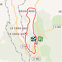
Randonnée V.T.T. de 6,6 km à découvrir à Auvergne-Rhône-Alpes, Puy-de-Dôme, Orcival. Cette randonnée est proposée par tracegps.
Description
Situé à 20 km de Murol : Chambon sur Lac D996, continuer sur 15 kms environ, tourner à droite direction D983 sur 6 km, l'observatoire se trouve près de l'embranchement entre Orcival et le Mont Dore. Continuer sur la départementale por arriver au départ du circuit. En plus il y a un parking sur le bord de la route. Roches Tuilières et Roches Sanadoire à Orcival : ces volcans, voisins mais d'origine différentes, représentent des vestiges d'une pittoresque vallée glaciaire. On peut y admirer des orgues basaltiques détachables en lames. Ces deux rochers semblant se faire face dans une lutte sans merci, sont apparus il y a 2 millions d'années. La roche Sanadoire est une prismation en dalle et la roche Tuilière est une prismation en gerbe. Au centre de ces protrusions, une vallée apparait aujourd'hui à l'horizon : à gauche Le cros et à droite la Vallée du Chausse. ROCHE TUILIERE (1288 m) Roche surnommé ainsi car il s'agit d'un ancien volcan dont une des parties s'est éboulée. Cet ancien volcan a la forme d'un arc de cercle. ROCHE SANADOIRE (1286 m) Roche située à proximité de la Roche Tuilière. La roche sanadoire est aussi un ancien volcan dont la cheminée a été dégagée suite à l'éboulement d'une partie du volcan.
Localisation
Commentaires
Randonnées à proximité
![Randonnée Marche Orcival - Lac de Servières à partir du Café du Lac - Photo](https://media.geolcdn.com/t/375/260/d4f759b9-e870-4661-990b-869b6d13ddb5.jpeg&format=jpg&maxdim=2)
![Marche Marche](https://static1.geolcdn.com/sitytour/trail-icons/101.png)
Marche
![](/images/other/stat-length.png)
![](https://static1.geolcdn.com/siteimages/upload/files/16400158638029165_repeat_loop_refresh_sync_direction_icon.png)
![Marche Marche](https://static1.geolcdn.com/sitytour/trail-icons/101.png)
Marche
![](/images/other/stat-length.png)
![](https://static1.geolcdn.com/siteimages/upload/files/16400158638029165_repeat_loop_refresh_sync_direction_icon.png)
![Randonnée Marche Orcival - boucle du Puy de l Ouire - Photo](https://media.geolcdn.com/t/375/260/acae3307-d0e9-457f-8795-cbbba2239bb1.jpg&format=jpg&maxdim=2)
![Marche Marche](https://static1.geolcdn.com/sitytour/trail-icons/101.png)
Marche
![](/images/other/stat-length.png)
![](https://static1.geolcdn.com/siteimages/upload/files/16400158638029165_repeat_loop_refresh_sync_direction_icon.png)
![Randonnée Marche Vernines - Vernines_Vallee_Sioule - Photo](https://media.geolcdn.com/t/375/260/38e06b97-31c9-4cc6-a77a-c7870e58965b.jpg&format=jpg&maxdim=2)
![Marche Marche](https://static1.geolcdn.com/sitytour/trail-icons/101.png)
Marche
![](/images/other/stat-length.png)
![](https://static1.geolcdn.com/siteimages/upload/files/16400158638029165_repeat_loop_refresh_sync_direction_icon.png)
![Randonnée Marche Mont-Dore - Le puy de la tache, le lacs servières et guèry par la cascade du Queureuilh depuis l'Escalidou. - Photo](https://media.geolcdn.com/t/375/260/ext.jpg?maxdim=2&url=https%3A%2F%2Fservices.sitytrail.com%2FGeolivesWS%2FDownloadMedia.ashx%3FTrailID%3D228422%26Media%3D20131022164253.jpg)
![Marche Marche](https://static1.geolcdn.com/sitytour/trail-icons/101.png)
Marche
![](/images/other/stat-length.png)
![](https://static1.geolcdn.com/siteimages/upload/files/16400158638029165_repeat_loop_refresh_sync_direction_icon.png)
![Randonnée Marche Perpezat - Le lac de Guéry - Photo](https://media.geolcdn.com/t/375/260/ext.jpg?maxdim=2&url=https%3A%2F%2Fservices.sitytrail.com%2FGeolivesWS%2FDownloadMedia.ashx%3FTrailID%3D105682%26Media%3D9516_2.jpg)
![Marche Marche](https://static1.geolcdn.com/sitytour/trail-icons/101.png)
Marche
![](/images/other/stat-length.png)
![](https://static1.geolcdn.com/siteimages/upload/files/16400158638029165_repeat_loop_refresh_sync_direction_icon.png)
![Randonnée Marche Perpezat - quelques volcans - Photo](https://media.geolcdn.com/t/375/260/f39b4d03-1fff-4970-9dd3-3ef0b9b4dd15.jpg&format=jpg&maxdim=2)
![Marche Marche](https://static1.geolcdn.com/sitytour/trail-icons/101.png)
Marche
![](/images/other/stat-length.png)
![](https://static1.geolcdn.com/siteimages/upload/files/16400158638029165_repeat_loop_refresh_sync_direction_icon.png)
![Randonnée Marche Chambon-sur-Lac - Puy de l'Angle 2740m 11.5.24 - Photo](https://media.geolcdn.com/t/375/260/5513db9c-349d-4f05-bc76-5b9d618ca52c.jpg&format=jpg&maxdim=2)
![Marche Marche](https://static1.geolcdn.com/sitytour/trail-icons/101.png)
Marche
![](/images/other/stat-length.png)
![](https://static1.geolcdn.com/siteimages/upload/files/16400158638029165_repeat_loop_refresh_sync_direction_icon.png)
![Randonnée A pied Mont-Dore - Le Puy Gros - Photo](https://media.geolcdn.com/t/375/260/57e33af1-6a70-4dc9-a386-d267bcacc7aa.jpeg&format=jpg&maxdim=2)
![A pied A pied](https://static1.geolcdn.com/sitytour/trail-icons/100.png)
A pied
![](/images/other/stat-length.png)
![](https://static1.geolcdn.com/siteimages/upload/files/16400158638029165_repeat_loop_refresh_sync_direction_icon.png)