![](/images/other/stat-length.png)
![Randonnée Marche Saint-Martin-les-Eaux - De la Ferme de Borne à St Martin - Photo](https://media.geolcdn.com/t/1900/400/ext.pjpeg?maxdim=2&url=https%3A%2F%2Fservices.sitytrail.com%2FGeolivesWS%2FDownloadMedia.ashx%3FTrailID%3D1017081%26Media%3Dfix__20180711083036.jpg)
De la Ferme de Borne à St Martin
liocol
Utilisateur
![Longueur](/images/other/stat-length.png)
Longueur
6,3 km
![Altitude max](https://static1.geolcdn.com/siteimages/upload/files/1508320355ic_sort_altitude_max_24dp.png)
Altitude max
656 m
![Dénivelé positif](https://static1.geolcdn.com/siteimages/upload/files/1508320355ic_sort_den_pos_24dp.png)
Dénivelé positif
176 m
![Km-Effort](/images/other/stat-length.png)
Km-Effort
8,6 km
![Altitude min](https://static1.geolcdn.com/siteimages/upload/files/1508320355ic_sort_altitude_min_24dp.png)
Altitude min
519 m
![Dénivelé négatif](https://static1.geolcdn.com/siteimages/upload/files/1508320355ic_sort_den_neg_24dp.png)
Dénivelé négatif
177 m
![Boucle](https://static1.geolcdn.com/siteimages/upload/files/16400158638029165_repeat_loop_refresh_sync_direction_icon.png)
Boucle
Oui
Date de création :
2019-01-15 14:10:37.181
Dernière modification :
2019-01-15 14:10:37.181
![Marche](https://static1.geolcdn.com/sitytour/trail-icons/101.png)
1h49
Difficulté : Facile
![Scannez ce code QR pour ouvrir la randonnée dans l'application SityTrail](https://capi.geolives.com/qq0zvz2zws4bq2lad0pu/sitytour/trails/1017081/qr.png?size=200)
Application GPS de randonnée GRATUITE
À propos
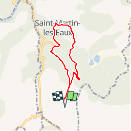
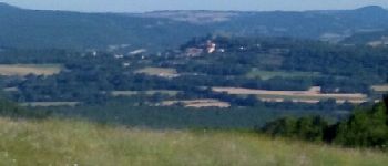
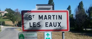
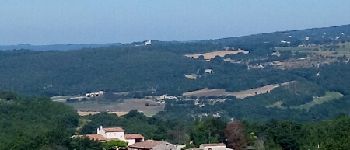
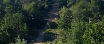
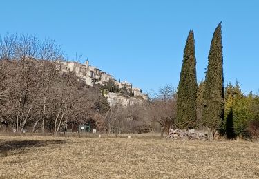
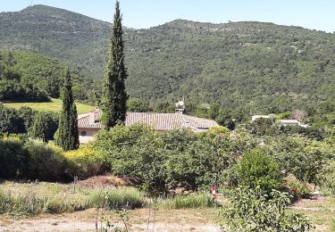
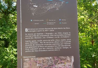
Randonnée Marche de 6,3 km à découvrir à Provence-Alpes-Côte d'Azur, Alpes-de-Haute-Provence, Saint-Martin-les-Eaux. Cette randonnée est proposée par liocol.
Description
Une belle boucle de 2 petites heures, avec la visite de Saint Martin les eaux. Se garer à gauche de la route.
Points d'intérêt
Localisation
Pays :
France
Région :
Provence-Alpes-Côte d'Azur
Département/Province :
Alpes-de-Haute-Provence
Commune :
Saint-Martin-les-Eaux
Localité :
Unknown
Départ:(Dec)
Départ:(UTM)
719938 ; 4859382 (31T) N.
Commentaires
Randonnées à proximité
![Randonnée Marche Dauphin - DAUPHIN La forêt de Pelissier o - Photo](https://media.geolcdn.com/t/375/260/38031732-1577-4607-ab9b-103e2562d975.jpg&format=jpg&maxdim=2)
![Marche Marche](https://static1.geolcdn.com/sitytour/trail-icons/101.png)
DAUPHIN La forêt de Pelissier o
Marche
Moyen
(1)
Dauphin,
Provence-Alpes-Côte d'Azur,
Alpes-de-Haute-Provence,
France
![](/images/other/stat-length.png)
15,2 km | 22 km-effort
4h 6min
![](https://static1.geolcdn.com/siteimages/upload/files/16400158638029165_repeat_loop_refresh_sync_direction_icon.png)
Oui
![Randonnée Marche Saint-Michel-l'Observatoire - LINCEL Moulin de l Agnelie o l - Photo](https://media.geolcdn.com/t/375/260/ext.jpg?maxdim=2&url=https%3A%2F%2Fstatic1.geolcdn.com%2Fsiteimages%2Fupload%2Ffiles%2F1553511878bg_sport_marche.png)
![Marche Marche](https://static1.geolcdn.com/sitytour/trail-icons/101.png)
LINCEL Moulin de l Agnelie o l
Marche
Facile
(1)
Saint-Michel-l'Observatoire,
Provence-Alpes-Côte d'Azur,
Alpes-de-Haute-Provence,
France
![](/images/other/stat-length.png)
13,6 km | 17,8 km-effort
6h 22min
![](https://static1.geolcdn.com/siteimages/upload/files/16400158638029165_repeat_loop_refresh_sync_direction_icon.png)
Oui
![Randonnée Marche Manosque - Le Val des Chats, avant le col de la Mort d'Imbert. - Photo](https://media.geolcdn.com/t/375/260/ext.jpg?maxdim=2&url=https%3A%2F%2Fservices.sitytrail.com%2FGeolivesWS%2FDownloadMedia.ashx%3FTrailID%3D897794%26Media%3Dfix__20180202095306.jpg)
![Marche Marche](https://static1.geolcdn.com/sitytour/trail-icons/101.png)
Le Val des Chats, avant le col de la Mort d'Imbert.
Marche
Facile
(2)
Manosque,
Provence-Alpes-Côte d'Azur,
Alpes-de-Haute-Provence,
France
![](/images/other/stat-length.png)
4,7 km | 6,5 km-effort
1h 23min
![](https://static1.geolcdn.com/siteimages/upload/files/16400158638029165_repeat_loop_refresh_sync_direction_icon.png)
Oui
![Randonnée Marche Manosque - MANOSQUE VOLX PAR LES COLLINES O S - Photo](https://media.geolcdn.com/t/375/260/704cb0ab-321f-4c7d-8564-495e7eaa472c.jpg&format=jpg&maxdim=2)
![Marche Marche](https://static1.geolcdn.com/sitytour/trail-icons/101.png)
MANOSQUE VOLX PAR LES COLLINES O S
Marche
Difficile
Manosque,
Provence-Alpes-Côte d'Azur,
Alpes-de-Haute-Provence,
France
![](/images/other/stat-length.png)
17,7 km | 24 km-effort
4h 15min
![](https://static1.geolcdn.com/siteimages/upload/files/16400158638029165_repeat_loop_refresh_sync_direction_icon.png)
Oui
![Randonnée Marche Manosque - Le tour de la borie '' pain de sucre '' - Photo](https://media.geolcdn.com/t/375/260/ext.jpg?maxdim=2&url=https%3A%2F%2Fstatic1.geolcdn.com%2Fsiteimages%2Fupload%2Ffiles%2F1553511878bg_sport_marche.png)
![Marche Marche](https://static1.geolcdn.com/sitytour/trail-icons/101.png)
Le tour de la borie '' pain de sucre ''
Marche
Facile
(1)
Manosque,
Provence-Alpes-Côte d'Azur,
Alpes-de-Haute-Provence,
France
![](/images/other/stat-length.png)
5,1 km | 7,4 km-effort
1h 43min
![](https://static1.geolcdn.com/siteimages/upload/files/16400158638029165_repeat_loop_refresh_sync_direction_icon.png)
Oui
![Randonnée Marche Manosque - Quartier des Espels, départ Piscine. - Photo](https://media.geolcdn.com/t/375/260/ext.jpg?maxdim=2&url=https%3A%2F%2Fstatic1.geolcdn.com%2Fsiteimages%2Fupload%2Ffiles%2F1553511878bg_sport_marche.png)
![Marche Marche](https://static1.geolcdn.com/sitytour/trail-icons/101.png)
Quartier des Espels, départ Piscine.
Marche
Facile
(1)
Manosque,
Provence-Alpes-Côte d'Azur,
Alpes-de-Haute-Provence,
France
![](/images/other/stat-length.png)
4,8 km | 7,3 km-effort
1h 50min
![](https://static1.geolcdn.com/siteimages/upload/files/16400158638029165_repeat_loop_refresh_sync_direction_icon.png)
Oui
![Randonnée Marche Manosque - 1Les speels, le relais, le pain de sucre. Depart Crématoriome. - Photo](https://media.geolcdn.com/t/375/260/6283877c-2ac3-4309-9701-717eb3cc7193.jpg&format=jpg&maxdim=2)
![Marche Marche](https://static1.geolcdn.com/sitytour/trail-icons/101.png)
1Les speels, le relais, le pain de sucre. Depart Crématoriome.
Marche
Moyen
(1)
Manosque,
Provence-Alpes-Côte d'Azur,
Alpes-de-Haute-Provence,
France
![](/images/other/stat-length.png)
6,1 km | 9,7 km-effort
2h 4min
![](https://static1.geolcdn.com/siteimages/upload/files/16400158638029165_repeat_loop_refresh_sync_direction_icon.png)
Oui
![Randonnée Marche Saint-Michel-l'Observatoire - de Saint Martin les eaux à biabaux . la chapelle de hurage - Photo](https://media.geolcdn.com/t/375/260/1103c497-ef10-4118-a51b-b2420679ed1c.jpg&format=jpg&maxdim=2)
![Marche Marche](https://static1.geolcdn.com/sitytour/trail-icons/101.png)
de Saint Martin les eaux à biabaux . la chapelle de hurage
Marche
Facile
Saint-Michel-l'Observatoire,
Provence-Alpes-Côte d'Azur,
Alpes-de-Haute-Provence,
France
![](/images/other/stat-length.png)
9,4 km | 13,1 km-effort
2h 51min
![](https://static1.geolcdn.com/siteimages/upload/files/16400158638029165_repeat_loop_refresh_sync_direction_icon.png)
Oui
![Randonnée Marche Saint-Martin-les-Eaux - 1Domaine de Bourne - Photo](https://media.geolcdn.com/t/375/260/80f6f537-be43-4ee4-a47d-fb6f1cabac0e.jpg&format=jpg&maxdim=2)
![Marche Marche](https://static1.geolcdn.com/sitytour/trail-icons/101.png)
1Domaine de Bourne
Marche
Moyen
Saint-Martin-les-Eaux,
Provence-Alpes-Côte d'Azur,
Alpes-de-Haute-Provence,
France
![](/images/other/stat-length.png)
5,6 km | 8,3 km-effort
2h 2min
![](https://static1.geolcdn.com/siteimages/upload/files/16400158638029165_repeat_loop_refresh_sync_direction_icon.png)
Oui