![](/images/other/stat-length.png)
![Randonnée V.T.T. Bagnères-de-Bigorre - Espace VTT FFC Haute Bigorre - Circuit n°10 - Le Tour du Bédat - Photo](https://media.geolcdn.com/t/1900/400/ext.pjpeg?maxdim=2&url=https%3A%2F%2Fservices.sitytrail.com%2FGeolivesWS%2FDownloadMedia.ashx%3FTrailID%3D101643%26Media%3D1851_1.jpg)
Espace VTT FFC Haute Bigorre - Circuit n°10 - Le Tour du Bédat
tracegps
Utilisateur
![Longueur](/images/other/stat-length.png)
Longueur
6,5 km
![Altitude max](https://static1.geolcdn.com/siteimages/upload/files/1508320355ic_sort_altitude_max_24dp.png)
Altitude max
804 m
![Dénivelé positif](https://static1.geolcdn.com/siteimages/upload/files/1508320355ic_sort_den_pos_24dp.png)
Dénivelé positif
298 m
![Km-Effort](/images/other/stat-length.png)
Km-Effort
10,5 km
![Altitude min](https://static1.geolcdn.com/siteimages/upload/files/1508320355ic_sort_altitude_min_24dp.png)
Altitude min
569 m
![Dénivelé négatif](https://static1.geolcdn.com/siteimages/upload/files/1508320355ic_sort_den_neg_24dp.png)
Dénivelé négatif
288 m
![Boucle](https://static1.geolcdn.com/siteimages/upload/files/16400158638029165_repeat_loop_refresh_sync_direction_icon.png)
Boucle
Oui
Date de création :
2014-12-10 00:00:00.0
Dernière modification :
2014-12-10 00:00:00.0
![V.T.T.](https://static1.geolcdn.com/sitytour/trail-icons/202.png)
1h30
Difficulté : Difficile
![Scannez ce code QR pour ouvrir la randonnée dans l'application SityTrail](https://capi.geolives.com/qq0zvz2zws4bq2lad0pu/sitytour/trails/101643/qr.png?size=200)
Application GPS de randonnée GRATUITE
À propos
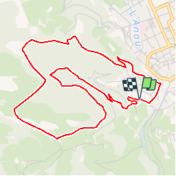
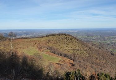
Randonnée V.T.T. de 6,5 km à découvrir à Occitanie, Hautes-Pyrénées, Bagnères-de-Bigorre. Cette randonnée est proposée par tracegps.
Description
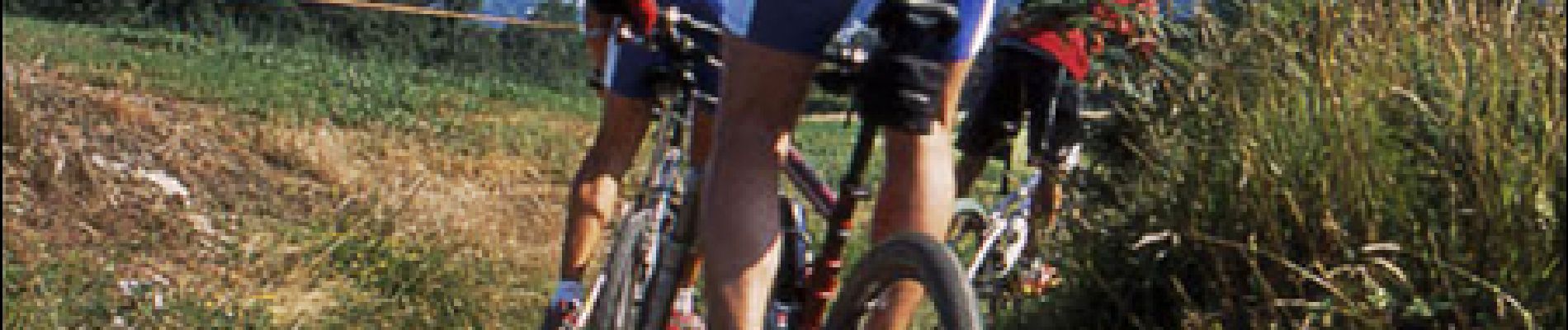
Haute Bigorre Circuit labellisé par la Fédération Française de Cyclisme. Col du Mont Olivet ; un endroit idéal pour une pause à l’ombre des chênes. Téléchargez le descriptif et le plan.
Localisation
Pays :
France
Région :
Occitanie
Département/Province :
Hautes-Pyrénées
Commune :
Bagnères-de-Bigorre
Localité :
Unknown
Départ:(Dec)
Départ:(UTM)
267528 ; 4771436 (31T) N.
Commentaires
Randonnées à proximité
![Randonnée Marche Bagnères-de-Bigorre - FEU 2015 - Etape 5 - Photo](https://media.geolcdn.com/t/375/260/ext.jpg?maxdim=2&url=https%3A%2F%2Fstatic1.geolcdn.com%2Fsiteimages%2Fupload%2Ffiles%2F1553511878bg_sport_marche.png)
![Marche Marche](https://static1.geolcdn.com/sitytour/trail-icons/101.png)
FEU 2015 - Etape 5
Marche
Facile
(1)
Bagnères-de-Bigorre,
Occitanie,
Hautes-Pyrénées,
France
![](/images/other/stat-length.png)
18,2 km | 30 km-effort
6h 29min
![](https://static1.geolcdn.com/siteimages/upload/files/16400158638029165_repeat_loop_refresh_sync_direction_icon.png)
Non
![Randonnée Marche Bagnères-de-Bigorre - Gerde - Photo](https://media.geolcdn.com/t/375/260/5dcd799a-ca45-4fad-9e66-85989c427a1f.jpg&format=jpg&maxdim=2)
![Marche Marche](https://static1.geolcdn.com/sitytour/trail-icons/101.png)
Gerde
Marche
Facile
Bagnères-de-Bigorre,
Occitanie,
Hautes-Pyrénées,
France
![](/images/other/stat-length.png)
9,7 km | 12,2 km-effort
2h 49min
![](https://static1.geolcdn.com/siteimages/upload/files/16400158638029165_repeat_loop_refresh_sync_direction_icon.png)
Oui
![Randonnée Marche Pouzac - Camp César Pouzac - Photo](https://media.geolcdn.com/t/375/260/d02bdd6b-08fe-4790-b056-6ee213cbd70c.jpg&format=jpg&maxdim=2)
![Marche Marche](https://static1.geolcdn.com/sitytour/trail-icons/101.png)
Camp César Pouzac
Marche
Moyen
Pouzac,
Occitanie,
Hautes-Pyrénées,
France
![](/images/other/stat-length.png)
6,6 km | 9,8 km-effort
1h 46min
![](https://static1.geolcdn.com/siteimages/upload/files/16400158638029165_repeat_loop_refresh_sync_direction_icon.png)
Oui
![Randonnée Marche Gerde - Casque du Lheris - Photo](https://media.geolcdn.com/t/375/260/127d6360-7ed6-475e-a89b-3eca1405854b.jpg&format=jpg&maxdim=2)
![Marche Marche](https://static1.geolcdn.com/sitytour/trail-icons/101.png)
Casque du Lheris
Marche
Moyen
Gerde,
Occitanie,
Hautes-Pyrénées,
France
![](/images/other/stat-length.png)
16,8 km | 28 km-effort
6h 25min
![](https://static1.geolcdn.com/siteimages/upload/files/16400158638029165_repeat_loop_refresh_sync_direction_icon.png)
Oui
![Randonnée Vélo de route Beaudéan - hourquette - Photo](https://media.geolcdn.com/t/375/260/ext.jpg?maxdim=2&url=https%3A%2F%2Fstatic1.geolcdn.com%2Fsiteimages%2Fupload%2Ffiles%2F1524743154velo.jpg)
![Vélo de route Vélo de route](https://static1.geolcdn.com/sitytour/trail-icons/201.png)
hourquette
Vélo de route
Très difficile
(1)
Beaudéan,
Occitanie,
Hautes-Pyrénées,
France
![](/images/other/stat-length.png)
50 km | 65 km-effort
2h 54min
![](https://static1.geolcdn.com/siteimages/upload/files/16400158638029165_repeat_loop_refresh_sync_direction_icon.png)
Oui
![Randonnée V.T.T. Bagnères-de-Bigorre - Randonnée 1 mai haut de Bagneres - Photo](https://media.geolcdn.com/t/375/260/4a87d4a3-5d4a-42ce-b248-b29ff1010a7f.jpg&format=jpg&maxdim=2)
![V.T.T. V.T.T.](https://static1.geolcdn.com/sitytour/trail-icons/202.png)
Randonnée 1 mai haut de Bagneres
V.T.T.
Très difficile
Bagnères-de-Bigorre,
Occitanie,
Hautes-Pyrénées,
France
![](/images/other/stat-length.png)
28 km | 38 km-effort
3h 18min
![](https://static1.geolcdn.com/siteimages/upload/files/16400158638029165_repeat_loop_refresh_sync_direction_icon.png)
Oui
![Randonnée Marche Bagnères-de-Bigorre - Bedat par croix de Manse - Photo](https://media.geolcdn.com/t/375/260/ext.jpg?maxdim=2&url=https%3A%2F%2Fservices.sitytrail.com%2FGeolivesWS%2FDownloadMedia.ashx%3FTrailID%3D1028179%26Media%3Dfix__20180824133821.jpg)
![Marche Marche](https://static1.geolcdn.com/sitytour/trail-icons/101.png)
Bedat par croix de Manse
Marche
Très facile
Bagnères-de-Bigorre,
Occitanie,
Hautes-Pyrénées,
France
![](/images/other/stat-length.png)
6 km | 8,8 km-effort
3h 48min
![](https://static1.geolcdn.com/siteimages/upload/files/16400158638029165_repeat_loop_refresh_sync_direction_icon.png)
Oui
![Randonnée Marche Bagnères-de-Bigorre - Bedat par croix de Manse - Photo](https://media.geolcdn.com/t/375/260/ext.jpg?maxdim=2&url=https%3A%2F%2Fservices.sitytrail.com%2FGeolivesWS%2FDownloadMedia.ashx%3FTrailID%3D1028018%26Media%3Dfix__20180824133821.jpg)
![Marche Marche](https://static1.geolcdn.com/sitytour/trail-icons/101.png)
Bedat par croix de Manse
Marche
Très facile
Bagnères-de-Bigorre,
Occitanie,
Hautes-Pyrénées,
France
![](/images/other/stat-length.png)
6 km | 8,8 km-effort
3h 48min
![](https://static1.geolcdn.com/siteimages/upload/files/16400158638029165_repeat_loop_refresh_sync_direction_icon.png)
Oui
![Randonnée Marche Bagnères-de-Bigorre - tour du castelmouly - Photo](https://media.geolcdn.com/t/375/260/ext.jpg?maxdim=2&url=https%3A%2F%2Fservices.sitytrail.com%2FGeolivesWS%2FDownloadMedia.ashx%3FTrailID%3D311996%26Media%3Dfix__20140611120606.jpg)
![Marche Marche](https://static1.geolcdn.com/sitytour/trail-icons/101.png)
tour du castelmouly
Marche
Facile
(2)
Bagnères-de-Bigorre,
Occitanie,
Hautes-Pyrénées,
France
![](/images/other/stat-length.png)
12,7 km | 20 km-effort
4h 3min
![](https://static1.geolcdn.com/siteimages/upload/files/16400158638029165_repeat_loop_refresh_sync_direction_icon.png)
Oui