![](/images/other/stat-length.png)
![Randonnée V.T.T. Villars - Villars Rustrel - Photo](https://media.geolcdn.com/t/1900/400/ext.pjpeg?maxdim=2&url=https%3A%2F%2Fstatic1.geolcdn.com%2Fsiteimages%2Fupload%2Ffiles%2F1524743154velo.jpg)
Villars Rustrel
tracegps
Utilisateur
![Longueur](/images/other/stat-length.png)
Longueur
39 km
![Altitude max](https://static1.geolcdn.com/siteimages/upload/files/1508320355ic_sort_altitude_max_24dp.png)
Altitude max
574 m
![Dénivelé positif](https://static1.geolcdn.com/siteimages/upload/files/1508320355ic_sort_den_pos_24dp.png)
Dénivelé positif
1007 m
![Km-Effort](/images/other/stat-length.png)
Km-Effort
53 km
![Altitude min](https://static1.geolcdn.com/siteimages/upload/files/1508320355ic_sort_altitude_min_24dp.png)
Altitude min
281 m
![Dénivelé négatif](https://static1.geolcdn.com/siteimages/upload/files/1508320355ic_sort_den_neg_24dp.png)
Dénivelé négatif
1015 m
![Boucle](https://static1.geolcdn.com/siteimages/upload/files/16400158638029165_repeat_loop_refresh_sync_direction_icon.png)
Boucle
Non
Date de création :
2014-12-10 00:00:00.0
Dernière modification :
2014-12-10 00:00:00.0
![V.T.T.](https://static1.geolcdn.com/sitytour/trail-icons/202.png)
3h30
Difficulté : Difficile
![Scannez ce code QR pour ouvrir la randonnée dans l'application SityTrail](https://capi.geolives.com/qq0zvz2zws4bq2lad0pu/sitytour/trails/101639/qr.png?size=200)
Application GPS de randonnée GRATUITE
À propos
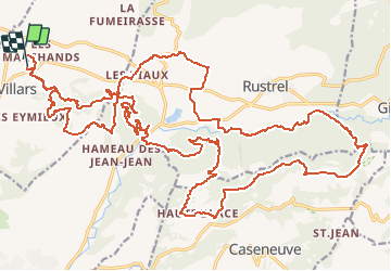
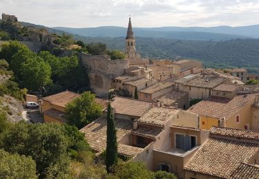
Randonnée V.T.T. de 39 km à découvrir à Provence-Alpes-Côte d'Azur, Vaucluse, Villars. Cette randonnée est proposée par tracegps.
Description
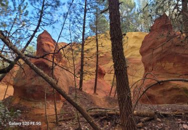
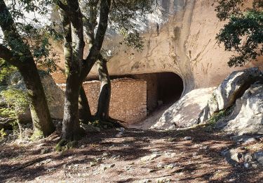
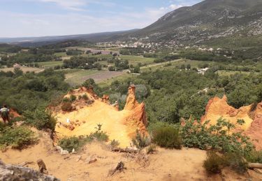
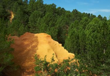
Un superbe parcours dans les orcres du colorado provencal, possibilité de réduire en 25 ou meme 15km. Un passage execptionnel dans une galerie de mine d ocre. Du pur bonheur pour les yeux, de beaux singles en descente et en montée.
Localisation
Pays :
France
Région :
Provence-Alpes-Côte d'Azur
Département/Province :
Vaucluse
Commune :
Villars
Localité :
Unknown
Départ:(Dec)
Départ:(UTM)
693276 ; 4866959 (31T) N.
Commentaires
Randonnées à proximité
![Randonnée Marche Villars - Chapelle st Pierre Aiguiers d' Auribeau - Photo](https://media.geolcdn.com/t/375/260/ext.jpg?maxdim=2&url=https%3A%2F%2Fstatic1.geolcdn.com%2Fsiteimages%2Fupload%2Ffiles%2F1553511878bg_sport_marche.png)
![Marche Marche](https://static1.geolcdn.com/sitytour/trail-icons/101.png)
Chapelle st Pierre Aiguiers d' Auribeau
Marche
Facile
(1)
Villars,
Provence-Alpes-Côte d'Azur,
Vaucluse,
France
![](/images/other/stat-length.png)
10,9 km | 17,8 km-effort
4h 43min
![](https://static1.geolcdn.com/siteimages/upload/files/16400158638029165_repeat_loop_refresh_sync_direction_icon.png)
Oui
![Randonnée Marche Villars - PF-Villars - Les Ocres des Bruyères - l'Aiguier d'Auribeau - CJ - Photo](https://media.geolcdn.com/t/375/260/327e4e7a-d540-4609-af6e-f746d82ce16c.jpg&format=jpg&maxdim=2)
![Marche Marche](https://static1.geolcdn.com/sitytour/trail-icons/101.png)
PF-Villars - Les Ocres des Bruyères - l'Aiguier d'Auribeau - CJ
Marche
Très difficile
Villars,
Provence-Alpes-Côte d'Azur,
Vaucluse,
France
![](/images/other/stat-length.png)
14,3 km | 22 km-effort
5h 1min
![](https://static1.geolcdn.com/siteimages/upload/files/16400158638029165_repeat_loop_refresh_sync_direction_icon.png)
Oui
![Randonnée Marche Saint-Saturnin-lès-Apt - Tour des Aiguiers-St Saturnin des Apt09-05-23 - Photo](https://media.geolcdn.com/t/375/260/d312fcbf-b0cf-4b76-815f-5442f1d28b2d.jpg&format=jpg&maxdim=2)
![Marche Marche](https://static1.geolcdn.com/sitytour/trail-icons/101.png)
Tour des Aiguiers-St Saturnin des Apt09-05-23
Marche
Moyen
Saint-Saturnin-lès-Apt,
Provence-Alpes-Côte d'Azur,
Vaucluse,
France
![](/images/other/stat-length.png)
12,1 km | 17,9 km-effort
3h 43min
![](https://static1.geolcdn.com/siteimages/upload/files/16400158638029165_repeat_loop_refresh_sync_direction_icon.png)
Oui
![Randonnée Marche Saint-Saturnin-lès-Apt - APT S Saturnin d Apt , sentier des Auguiers et des bornes o - Photo](https://media.geolcdn.com/t/375/260/f4ec053c-09d8-429f-af97-5e267836d6e1.jpg&format=jpg&maxdim=2)
![Marche Marche](https://static1.geolcdn.com/sitytour/trail-icons/101.png)
APT S Saturnin d Apt , sentier des Auguiers et des bornes o
Marche
Moyen
Saint-Saturnin-lès-Apt,
Provence-Alpes-Côte d'Azur,
Vaucluse,
France
![](/images/other/stat-length.png)
15,2 km | 21 km-effort
4h 0min
![](https://static1.geolcdn.com/siteimages/upload/files/16400158638029165_repeat_loop_refresh_sync_direction_icon.png)
Oui
![Randonnée Marche Villars - Les Aiguiers du Villars par Cabrone - Photo](https://media.geolcdn.com/t/375/260/e3a23535-df22-4f6f-b825-7ba3c861147b.jpg&format=jpg&maxdim=2)
![Marche Marche](https://static1.geolcdn.com/sitytour/trail-icons/101.png)
Les Aiguiers du Villars par Cabrone
Marche
Difficile
(1)
Villars,
Provence-Alpes-Côte d'Azur,
Vaucluse,
France
![](/images/other/stat-length.png)
17,7 km | 27 km-effort
4h 36min
![](https://static1.geolcdn.com/siteimages/upload/files/16400158638029165_repeat_loop_refresh_sync_direction_icon.png)
Oui
![Randonnée Marche Saint-Saturnin-lès-Apt - st saturnin, les Aiguiers Grognards - Photo](https://media.geolcdn.com/t/375/260/0d35eb36-498f-4a8e-88e2-3e9aa73364c7.jpg&format=jpg&maxdim=2)
![Marche Marche](https://static1.geolcdn.com/sitytour/trail-icons/101.png)
st saturnin, les Aiguiers Grognards
Marche
Difficile
Saint-Saturnin-lès-Apt,
Provence-Alpes-Côte d'Azur,
Vaucluse,
France
![](/images/other/stat-length.png)
10,7 km | 17,5 km-effort
3h 8min
![](https://static1.geolcdn.com/siteimages/upload/files/16400158638029165_repeat_loop_refresh_sync_direction_icon.png)
Oui
![Randonnée Marche Rustrel - Colorado Rustrel - Photo](https://media.geolcdn.com/t/375/260/068c088d-591e-4a28-a861-59ce458f7131.jpg&format=jpg&maxdim=2)
![Marche Marche](https://static1.geolcdn.com/sitytour/trail-icons/101.png)
Colorado Rustrel
Marche
Très difficile
Rustrel,
Provence-Alpes-Côte d'Azur,
Vaucluse,
France
![](/images/other/stat-length.png)
18,7 km | 25 km-effort
6h 2min
![](https://static1.geolcdn.com/siteimages/upload/files/16400158638029165_repeat_loop_refresh_sync_direction_icon.png)
Oui
![Randonnée Marche Villars - Villars Colorado - Photo](https://media.geolcdn.com/t/375/260/ext.jpg?maxdim=2&url=https%3A%2F%2Fservices.sitytrail.com%2FGeolivesWS%2FDownloadMedia.ashx%3FTrailID%3D1042861%26Media%3Dfix__20180917103001.jpg)
![Marche Marche](https://static1.geolcdn.com/sitytour/trail-icons/101.png)
Villars Colorado
Marche
Facile
Villars,
Provence-Alpes-Côte d'Azur,
Vaucluse,
France
![](/images/other/stat-length.png)
3,3 km | 4,2 km-effort
54min
![](https://static1.geolcdn.com/siteimages/upload/files/16400158638029165_repeat_loop_refresh_sync_direction_icon.png)
Oui
![Randonnée Marche Saint-Saturnin-lès-Apt - Sainte Radegonde - Photo](https://media.geolcdn.com/t/375/260/ext.jpg?maxdim=2&url=https%3A%2F%2Fservices.sitytrail.com%2FGeolivesWS%2FDownloadMedia.ashx%3FTrailID%3D698427%26Media%3Dfix__20170214180016.jpg)
![Marche Marche](https://static1.geolcdn.com/sitytour/trail-icons/101.png)
Sainte Radegonde
Marche
Très facile
(1)
Saint-Saturnin-lès-Apt,
Provence-Alpes-Côte d'Azur,
Vaucluse,
France
![](/images/other/stat-length.png)
4,2 km | 5,9 km-effort
1h 16min
![](https://static1.geolcdn.com/siteimages/upload/files/16400158638029165_repeat_loop_refresh_sync_direction_icon.png)
Oui
tour très sympa.
Peut être superbe mais il faut le matériel adéquat par temps de pluie ou sur terrains gras. Des parties de ruisseaux à traverser difficilement.