![](/images/other/stat-length.png)
![Randonnée V.T.T. Sigournais - Circuit de Rochereau - Photo](https://media.geolcdn.com/t/1900/400/ext.pjpeg?maxdim=2&url=https%3A%2F%2Fservices.sitytrail.com%2FGeolivesWS%2FDownloadMedia.ashx%3FTrailID%3D101590%26Media%3D1729_6.jpg)
Circuit de Rochereau
tracegps
Utilisateur
![Longueur](/images/other/stat-length.png)
Longueur
24 km
![Altitude max](https://static1.geolcdn.com/siteimages/upload/files/1508320355ic_sort_altitude_max_24dp.png)
Altitude max
104 m
![Dénivelé positif](https://static1.geolcdn.com/siteimages/upload/files/1508320355ic_sort_den_pos_24dp.png)
Dénivelé positif
263 m
![Km-Effort](/images/other/stat-length.png)
Km-Effort
27 km
![Altitude min](https://static1.geolcdn.com/siteimages/upload/files/1508320355ic_sort_altitude_min_24dp.png)
Altitude min
45 m
![Dénivelé négatif](https://static1.geolcdn.com/siteimages/upload/files/1508320355ic_sort_den_neg_24dp.png)
Dénivelé négatif
267 m
![Boucle](https://static1.geolcdn.com/siteimages/upload/files/16400158638029165_repeat_loop_refresh_sync_direction_icon.png)
Boucle
Non
Date de création :
2014-12-10 00:00:00.0
Dernière modification :
2014-12-10 00:00:00.0
![V.T.T.](https://static1.geolcdn.com/sitytour/trail-icons/202.png)
2h15
Difficulté : Moyen
![Scannez ce code QR pour ouvrir la randonnée dans l'application SityTrail](https://capi.geolives.com/qq0zvz2zws4bq2lad0pu/sitytour/trails/101590/qr.png?size=200)
Application GPS de randonnée GRATUITE
À propos
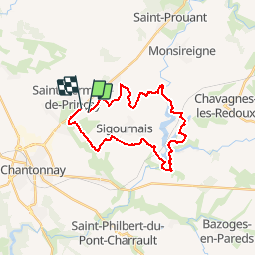
Randonnée V.T.T. de 24 km à découvrir à Pays de la Loire, Vendée, Sigournais. Cette randonnée est proposée par tracegps.
Description
Circuit facile sans grande difficulté, des suprbes paysages autour du lac du Rochereau. Possibilité de faire le circuit à pied.
Localisation
Pays :
France
Région :
Pays de la Loire
Département/Province :
Vendée
Commune :
Sigournais
Localité :
Unknown
Départ:(Dec)
Départ:(UTM)
651934 ; 5175320 (30T) N.
Commentaires
Randonnées à proximité
![Randonnée Autre activité Chantonnay - Circuit du lac de l'Angle Guignard - Chantonnay - Photo](https://media.geolcdn.com/t/375/260/ext.jpg?maxdim=2&url=http%3A%2F%2Ffichier1.cirkwi.com%2Fimage%2Fphoto%2Fpoi%2F1300x1300%2F62839%2Ffr%2F0.jpg)
![Autre activité Autre activité](https://static1.geolcdn.com/sitytour/trail-icons/900.png)
Circuit du lac de l'Angle Guignard - Chantonnay
Autre activité
Très facile
Chantonnay,
Pays de la Loire,
Vendée,
France
![](/images/other/stat-length.png)
13,9 km | 17,6 km-effort
Inconnu
![](https://static1.geolcdn.com/siteimages/upload/files/16400158638029165_repeat_loop_refresh_sync_direction_icon.png)
Oui
![Randonnée Marche Chantonnay - Chantonnay - La Jaudonniere - Photo](https://media.geolcdn.com/t/375/260/defc772f-a5e9-44e0-b4dd-5c91f360d21c.jpg&format=jpg&maxdim=2)
![Marche Marche](https://static1.geolcdn.com/sitytour/trail-icons/101.png)
Chantonnay - La Jaudonniere
Marche
Difficile
Chantonnay,
Pays de la Loire,
Vendée,
France
![](/images/other/stat-length.png)
14 km | 16,7 km-effort
3h 11min
![](https://static1.geolcdn.com/siteimages/upload/files/16400158638029165_repeat_loop_refresh_sync_direction_icon.png)
Non
![Randonnée Marche Chantonnay - GR364-Jour n° 5 - Photo](https://media.geolcdn.com/t/375/260/ext.jpg?maxdim=2&url=https%3A%2F%2Fstatic1.geolcdn.com%2Fsiteimages%2Fupload%2Ffiles%2F1553511878bg_sport_marche.png)
![Marche Marche](https://static1.geolcdn.com/sitytour/trail-icons/101.png)
GR364-Jour n° 5
Marche
Très difficile
Chantonnay,
Pays de la Loire,
Vendée,
France
![](/images/other/stat-length.png)
25 km | 30 km-effort
6h 49min
![](https://static1.geolcdn.com/siteimages/upload/files/16400158638029165_repeat_loop_refresh_sync_direction_icon.png)
Non
![Randonnée Marche Saint-Prouant - Le Sentier du Bois Saint-Prouant 12 km - Photo](https://media.geolcdn.com/t/375/260/ext.jpg?maxdim=2&url=https%3A%2F%2Fstatic1.geolcdn.com%2Fsiteimages%2Fupload%2Ffiles%2F1553511878bg_sport_marche.png)
![Marche Marche](https://static1.geolcdn.com/sitytour/trail-icons/101.png)
Le Sentier du Bois Saint-Prouant 12 km
Marche
Difficile
Saint-Prouant,
Pays de la Loire,
Vendée,
France
![](/images/other/stat-length.png)
11,9 km | 13,3 km-effort
3h 0min
![](https://static1.geolcdn.com/siteimages/upload/files/16400158638029165_repeat_loop_refresh_sync_direction_icon.png)
Oui
![Randonnée Marche Chantonnay - Chantonnay la caillere st hilaire - Photo](https://media.geolcdn.com/t/375/260/ext.jpg?maxdim=2&url=https%3A%2F%2Fstatic1.geolcdn.com%2Fsiteimages%2Fupload%2Ffiles%2F1553511878bg_sport_marche.png)
![Marche Marche](https://static1.geolcdn.com/sitytour/trail-icons/101.png)
Chantonnay la caillere st hilaire
Marche
Moyen
Chantonnay,
Pays de la Loire,
Vendée,
France
![](/images/other/stat-length.png)
20 km | 24 km-effort
6h 16min
![](https://static1.geolcdn.com/siteimages/upload/files/16400158638029165_repeat_loop_refresh_sync_direction_icon.png)
Non
![Randonnée Vélo de route Chantonnay - Plaine de Chantonnay et Château d'eau de la Vendée - Photo](https://media.geolcdn.com/t/375/260/ext.jpg?maxdim=2&url=https%3A%2F%2Fstatic1.geolcdn.com%2Fsiteimages%2Fupload%2Ffiles%2F1524743154velo.jpg)
![Vélo de route Vélo de route](https://static1.geolcdn.com/sitytour/trail-icons/201.png)
Plaine de Chantonnay et Château d'eau de la Vendée
Vélo de route
Moyen
Chantonnay,
Pays de la Loire,
Vendée,
France
![](/images/other/stat-length.png)
59 km | 68 km-effort
3h 59min
![](https://static1.geolcdn.com/siteimages/upload/files/16400158638029165_repeat_loop_refresh_sync_direction_icon.png)
Oui
![Randonnée Marche Chantonnay - Sentier de la Nouette - Chantonnay - Photo](https://media.geolcdn.com/t/375/260/ext.jpg?maxdim=2&url=https%3A%2F%2Fstatic1.geolcdn.com%2Fsiteimages%2Fupload%2Ffiles%2F1553511878bg_sport_marche.png)
![Marche Marche](https://static1.geolcdn.com/sitytour/trail-icons/101.png)
Sentier de la Nouette - Chantonnay
Marche
Difficile
Chantonnay,
Pays de la Loire,
Vendée,
France
![](/images/other/stat-length.png)
12,5 km | 15,2 km-effort
3h 17min
![](https://static1.geolcdn.com/siteimages/upload/files/16400158638029165_repeat_loop_refresh_sync_direction_icon.png)
Oui
![Randonnée Marche Chantonnay - Circuit du lac de l'Angle Guignard - Chantonnay - Photo](https://media.geolcdn.com/t/375/260/ext.jpg?maxdim=2&url=https%3A%2F%2Fstatic1.geolcdn.com%2Fsiteimages%2Fupload%2Ffiles%2F1553511878bg_sport_marche.png)
![Marche Marche](https://static1.geolcdn.com/sitytour/trail-icons/101.png)
Circuit du lac de l'Angle Guignard - Chantonnay
Marche
Difficile
Chantonnay,
Pays de la Loire,
Vendée,
France
![](/images/other/stat-length.png)
13,9 km | 17,6 km-effort
3h 47min
![](https://static1.geolcdn.com/siteimages/upload/files/16400158638029165_repeat_loop_refresh_sync_direction_icon.png)
Oui
![Randonnée Marche Chantonnay - Sentier de Puybelliard par Ponsay - Chantonnay - Photo](https://media.geolcdn.com/t/375/260/ext.jpg?maxdim=2&url=https%3A%2F%2Fstatic1.geolcdn.com%2Fsiteimages%2Fupload%2Ffiles%2F1553511878bg_sport_marche.png)
![Marche Marche](https://static1.geolcdn.com/sitytour/trail-icons/101.png)
Sentier de Puybelliard par Ponsay - Chantonnay
Marche
Moyen
Chantonnay,
Pays de la Loire,
Vendée,
France
![](/images/other/stat-length.png)
10,3 km | 11,7 km-effort
2h 35min
![](https://static1.geolcdn.com/siteimages/upload/files/16400158638029165_repeat_loop_refresh_sync_direction_icon.png)
Oui