![](/images/other/stat-length.png)
![Randonnée V.T.T. Revel - Canal du Midi - Revel --> Pont Crouzet - Photo](https://media.geolcdn.com/t/1900/400/ext.pjpeg?maxdim=2&url=https%3A%2F%2Fstatic1.geolcdn.com%2Fsiteimages%2Fupload%2Ffiles%2F1524743154velo.jpg)
Canal du Midi - Revel --> Pont Crouzet
tracegps
Utilisateur
![Longueur](/images/other/stat-length.png)
Longueur
3,7 km
![Altitude max](https://static1.geolcdn.com/siteimages/upload/files/1508320355ic_sort_altitude_max_24dp.png)
Altitude max
250 m
![Dénivelé positif](https://static1.geolcdn.com/siteimages/upload/files/1508320355ic_sort_den_pos_24dp.png)
Dénivelé positif
32 m
![Km-Effort](/images/other/stat-length.png)
Km-Effort
4,1 km
![Altitude min](https://static1.geolcdn.com/siteimages/upload/files/1508320355ic_sort_altitude_min_24dp.png)
Altitude min
224 m
![Dénivelé négatif](https://static1.geolcdn.com/siteimages/upload/files/1508320355ic_sort_den_neg_24dp.png)
Dénivelé négatif
10 m
![Boucle](https://static1.geolcdn.com/siteimages/upload/files/16400158638029165_repeat_loop_refresh_sync_direction_icon.png)
Boucle
Non
Date de création :
2014-12-10 00:00:00.0
Dernière modification :
2014-12-10 00:00:00.0
![V.T.T.](https://static1.geolcdn.com/sitytour/trail-icons/202.png)
30m
Difficulté : Facile
![Scannez ce code QR pour ouvrir la randonnée dans l'application SityTrail](https://capi.geolives.com/qq0zvz2zws4bq2lad0pu/sitytour/trails/101475/qr.png?size=200)
Application GPS de randonnée GRATUITE
À propos
Randonnée V.T.T. de 3,7 km à découvrir à Occitanie, Haute-Garonne, Revel. Cette randonnée est proposée par tracegps.
Description
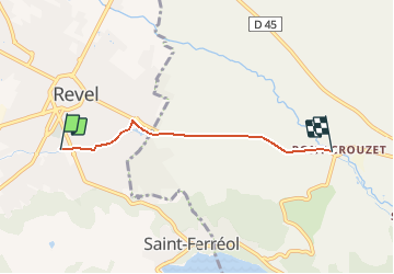
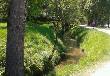
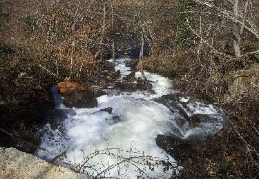
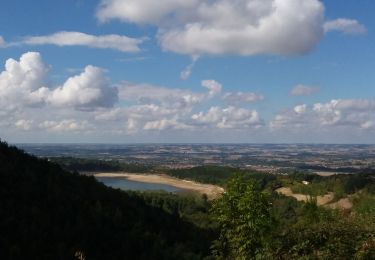
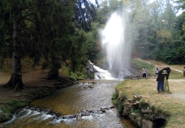
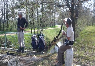
Circuit découverte Canal du Midi Circuit facile . Ce circuit longe la rigole de la plaine jusqu'à sa naissance à la prise d'eau du Sor au Pont Crouzet. Dénivelé positif 25m environ. D'autres informations disponibles chez les Randoactifs.
Localisation
Pays :
France
Région :
Occitanie
Département/Province :
Haute-Garonne
Commune :
Revel
Localité :
Unknown
Départ:(Dec)
Départ:(UTM)
419362 ; 4811464 (31T) N.
Commentaires
Randonnées à proximité
![Randonnée Marche Revel - Revel Saint Férréol en boucle - Photo](https://media.geolcdn.com/t/375/260/ext.jpg?maxdim=2&url=https%3A%2F%2Fservices.sitytrail.com%2FGeolivesWS%2FDownloadMedia.ashx%3FTrailID%3D419118%26Media%3Dfix__20150510160209.jpg)
![Marche Marche](https://static1.geolcdn.com/sitytour/trail-icons/101.png)
Revel Saint Férréol en boucle
Marche
Facile
(2)
Revel,
Occitanie,
Haute-Garonne,
France
![](/images/other/stat-length.png)
10,4 km | 13,3 km-effort
3h 16min
![](https://static1.geolcdn.com/siteimages/upload/files/16400158638029165_repeat_loop_refresh_sync_direction_icon.png)
Oui
![Randonnée V.T.T. Revel - Revel.vol à voile st ferreok - Photo](https://media.geolcdn.com/t/375/260/ext.jpg?maxdim=2&url=https%3A%2F%2Fstatic1.geolcdn.com%2Fsiteimages%2Fupload%2Ffiles%2F1524743154velo.jpg)
![V.T.T. V.T.T.](https://static1.geolcdn.com/sitytour/trail-icons/202.png)
Revel.vol à voile st ferreok
V.T.T.
Très facile
(1)
Revel,
Occitanie,
Haute-Garonne,
France
![](/images/other/stat-length.png)
28 km | 36 km-effort
1h 49min
![](https://static1.geolcdn.com/siteimages/upload/files/16400158638029165_repeat_loop_refresh_sync_direction_icon.png)
Oui
![Randonnée Course à pied Revel - Desperado Trail 31km - Photo](https://media.geolcdn.com/t/375/260/ext.jpg?maxdim=2&url=https%3A%2F%2Fstatic1.geolcdn.com%2Fsiteimages%2Fupload%2Ffiles%2F1524743154running.jpg)
![Course à pied Course à pied](https://static1.geolcdn.com/sitytour/trail-icons/103.png)
Desperado Trail 31km
Course à pied
Moyen
(1)
Revel,
Occitanie,
Haute-Garonne,
France
![](/images/other/stat-length.png)
31 km | 46 km-effort
3h 0min
![](https://static1.geolcdn.com/siteimages/upload/files/16400158638029165_repeat_loop_refresh_sync_direction_icon.png)
Non
![Randonnée V.T.T. Sorèze - 2012-04-01cammazes - Photo](https://media.geolcdn.com/t/375/260/ext.jpg?maxdim=2&url=https%3A%2F%2Fservices.sitytrail.com%2FGeolivesWS%2FDownloadMedia.ashx%3FTrailID%3D119424%26Media%3D20120401133653.jpeg)
![V.T.T. V.T.T.](https://static1.geolcdn.com/sitytour/trail-icons/202.png)
2012-04-01cammazes
V.T.T.
Difficile
(1)
Sorèze,
Occitanie,
Tarn,
France
![](/images/other/stat-length.png)
49 km | 63 km-effort
3h 17min
![](https://static1.geolcdn.com/siteimages/upload/files/16400158638029165_repeat_loop_refresh_sync_direction_icon.png)
Oui
![Randonnée Marche Les Brunels - Boucle entre le Lac de Saint Ferréol et la Lac des Cammazes - Photo](https://media.geolcdn.com/t/375/260/8c1c630c-128f-4e7c-b84b-3566584ac305.jpg&format=jpg&maxdim=2)
![Marche Marche](https://static1.geolcdn.com/sitytour/trail-icons/101.png)
Boucle entre le Lac de Saint Ferréol et la Lac des Cammazes
Marche
Difficile
Les Brunels,
Occitanie,
Aude,
France
![](/images/other/stat-length.png)
19,8 km | 28 km-effort
4h 58min
![](https://static1.geolcdn.com/siteimages/upload/files/16400158638029165_repeat_loop_refresh_sync_direction_icon.png)
Oui
![Randonnée A pied Revel - Tour du Lac - Photo](https://media.geolcdn.com/t/375/260/611f3337-9ba4-4c19-a478-877cf3d41242.jpeg&format=jpg&maxdim=2)
![A pied A pied](https://static1.geolcdn.com/sitytour/trail-icons/100.png)
Tour du Lac
A pied
Facile
Revel,
Occitanie,
Haute-Garonne,
France
![](/images/other/stat-length.png)
4,3 km | 4,8 km-effort
1h 5min
![](https://static1.geolcdn.com/siteimages/upload/files/16400158638029165_repeat_loop_refresh_sync_direction_icon.png)
Oui
![Randonnée Vélo Sorèze - De Revel à Mazamet - Photo](https://media.geolcdn.com/t/375/260/ext.jpg?maxdim=2&url=https%3A%2F%2Fservices.sitytrail.com%2FGeolivesWS%2FDownloadMedia.ashx%3FTrailID%3D215240%26Media%3D15861_3.jpg)
![Vélo Vélo](https://static1.geolcdn.com/sitytour/trail-icons/200.png)
![Randonnée Marche Revel - Revel - Les Cassés - Photo](https://media.geolcdn.com/t/375/260/ext.jpg?maxdim=2&url=https%3A%2F%2Fservices.sitytrail.com%2FGeolivesWS%2FDownloadMedia.ashx%3FTrailID%3D185393%26Media%3D20130416120139.jpeg)
![Marche Marche](https://static1.geolcdn.com/sitytour/trail-icons/101.png)
Revel - Les Cassés
Marche
Moyen
Revel,
Occitanie,
Haute-Garonne,
France
![](/images/other/stat-length.png)
22 km | 24 km-effort
1min
![](https://static1.geolcdn.com/siteimages/upload/files/16400158638029165_repeat_loop_refresh_sync_direction_icon.png)
Non
![Randonnée Marche Revel - Saint Férréol - Photo](https://media.geolcdn.com/t/375/260/ext.jpg?maxdim=2&url=https%3A%2F%2Fservices.sitytrail.com%2FGeolivesWS%2FDownloadMedia.ashx%3FTrailID%3D353891%26Media%3De3d9db61-9123-46aa-912c-44025d657da0.jpg)
![Marche Marche](https://static1.geolcdn.com/sitytour/trail-icons/101.png)
Saint Férréol
Marche
Très facile
Revel,
Occitanie,
Haute-Garonne,
France
![](/images/other/stat-length.png)
4,3 km | 4,8 km-effort
1h 0min
![](https://static1.geolcdn.com/siteimages/upload/files/16400158638029165_repeat_loop_refresh_sync_direction_icon.png)
Oui