![](/images/other/stat-length.png)
![Randonnée V.T.T. Esplas - Esplas 2006 - Photo](https://media.geolcdn.com/t/1900/400/ext.pjpeg?maxdim=2&url=https%3A%2F%2Fstatic1.geolcdn.com%2Fsiteimages%2Fupload%2Ffiles%2F1524743154velo.jpg)
Esplas 2006
tracegps
Utilisateur
![Longueur](/images/other/stat-length.png)
Longueur
52 km
![Altitude max](https://static1.geolcdn.com/siteimages/upload/files/1508320355ic_sort_altitude_max_24dp.png)
Altitude max
441 m
![Dénivelé positif](https://static1.geolcdn.com/siteimages/upload/files/1508320355ic_sort_den_pos_24dp.png)
Dénivelé positif
1231 m
![Km-Effort](/images/other/stat-length.png)
Km-Effort
69 km
![Altitude min](https://static1.geolcdn.com/siteimages/upload/files/1508320355ic_sort_altitude_min_24dp.png)
Altitude min
222 m
![Dénivelé négatif](https://static1.geolcdn.com/siteimages/upload/files/1508320355ic_sort_den_neg_24dp.png)
Dénivelé négatif
1235 m
![Boucle](https://static1.geolcdn.com/siteimages/upload/files/16400158638029165_repeat_loop_refresh_sync_direction_icon.png)
Boucle
Oui
Date de création :
2014-12-10 00:00:00.0
Dernière modification :
2014-12-10 00:00:00.0
![V.T.T.](https://static1.geolcdn.com/sitytour/trail-icons/202.png)
4h00
Difficulté : Très difficile
![Scannez ce code QR pour ouvrir la randonnée dans l'application SityTrail](https://capi.geolives.com/qq0zvz2zws4bq2lad0pu/sitytour/trails/101468/qr.png?size=200)
Application GPS de randonnée GRATUITE
À propos
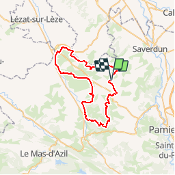
Randonnée V.T.T. de 52 km à découvrir à Occitanie, Ariège, Esplas. Cette randonnée est proposée par tracegps.
Description
Toujours sur Esplas dans l'Ariège, un petit village proche de Saverdun, cette rando propose des paysages superbes et une bonne variété de chemins: un bon plan aux portes de Toulouse
Localisation
Pays :
France
Région :
Occitanie
Département/Province :
Ariège
Commune :
Esplas
Localité :
Unknown
Départ:(Dec)
Départ:(UTM)
378000 ; 4782704 (31T) N.
Commentaires
Randonnées à proximité
![Randonnée Marche Saint-Martin-d'Oydes - St Martin d Oydes Esplas - Photo](https://media.geolcdn.com/t/375/260/ext.jpg?maxdim=2&url=https%3A%2F%2Fservices.sitytrail.com%2FGeolivesWS%2FDownloadMedia.ashx%3FTrailID%3D642488%26Media%3D749be763-57a3-4694-bdee-dc4a06f59480.JPG)
![Marche Marche](https://static1.geolcdn.com/sitytour/trail-icons/101.png)
St Martin d Oydes Esplas
Marche
Facile
Saint-Martin-d'Oydes,
Occitanie,
Ariège,
France
![](/images/other/stat-length.png)
12,2 km | 16 km-effort
3h 26min
![](https://static1.geolcdn.com/siteimages/upload/files/16400158638029165_repeat_loop_refresh_sync_direction_icon.png)
Oui
![Randonnée A pied Gaillac-Toulza - 6487049-Boucle de Louise (18.08.16) - Photo](https://media.geolcdn.com/t/375/260/ext.jpg?maxdim=2&url=https%3A%2F%2Fstatic1.geolcdn.com%2Fsiteimages%2Fupload%2Ffiles%2F1545311037marcheuse_200dpi.jpg)
![A pied A pied](https://static1.geolcdn.com/sitytour/trail-icons/100.png)
6487049-Boucle de Louise (18.08.16)
A pied
Facile
Gaillac-Toulza,
Occitanie,
Haute-Garonne,
France
![](/images/other/stat-length.png)
9,4 km | 12,1 km-effort
2h 10min
![](https://static1.geolcdn.com/siteimages/upload/files/16400158638029165_repeat_loop_refresh_sync_direction_icon.png)
Oui
![Randonnée Marche Brie - brie justiniac - Photo](https://media.geolcdn.com/t/375/260/ext.jpg?maxdim=2&url=https%3A%2F%2Fstatic1.geolcdn.com%2Fsiteimages%2Fupload%2Ffiles%2F1553511878bg_sport_marche.png)
![Marche Marche](https://static1.geolcdn.com/sitytour/trail-icons/101.png)
brie justiniac
Marche
Très facile
Brie,
Occitanie,
Ariège,
France
![](/images/other/stat-length.png)
8 km | 10,1 km-effort
1h 38min
![](https://static1.geolcdn.com/siteimages/upload/files/16400158638029165_repeat_loop_refresh_sync_direction_icon.png)
Oui
![Randonnée Marche Gaillac-Toulza - Gaillac Toulza:boucle de Louise - Photo](https://media.geolcdn.com/t/375/260/ext.jpg?maxdim=2&url=https%3A%2F%2Fstatic1.geolcdn.com%2Fsiteimages%2Fupload%2Ffiles%2F1553511878bg_sport_marche.png)
![Marche Marche](https://static1.geolcdn.com/sitytour/trail-icons/101.png)
Gaillac Toulza:boucle de Louise
Marche
Facile
Gaillac-Toulza,
Occitanie,
Haute-Garonne,
France
![](/images/other/stat-length.png)
9,4 km | 12,1 km-effort
2h 37min
![](https://static1.geolcdn.com/siteimages/upload/files/16400158638029165_repeat_loop_refresh_sync_direction_icon.png)
Oui
![Randonnée V.T.T. Esplas - Esplas 2007 - Photo](https://media.geolcdn.com/t/375/260/ext.jpg?maxdim=2&url=https%3A%2F%2Fstatic1.geolcdn.com%2Fsiteimages%2Fupload%2Ffiles%2F1524743154velo.jpg)
![V.T.T. V.T.T.](https://static1.geolcdn.com/sitytour/trail-icons/202.png)
![Randonnée Marche Artigat - Bajou Artigat fait 2022 - Photo](https://media.geolcdn.com/t/375/260/ext.jpg?maxdim=2&url=https%3A%2F%2Fstatic1.geolcdn.com%2Fsiteimages%2Fupload%2Ffiles%2F1553511878bg_sport_marche.png)
![Marche Marche](https://static1.geolcdn.com/sitytour/trail-icons/101.png)
Bajou Artigat fait 2022
Marche
Moyen
Artigat,
Occitanie,
Ariège,
France
![](/images/other/stat-length.png)
11,8 km | 0 m-effort
2h 50min
![](https://static1.geolcdn.com/siteimages/upload/files/16400158638029165_repeat_loop_refresh_sync_direction_icon.png)
Oui
![Randonnée Marche Brie - brie - Photo](https://media.geolcdn.com/t/375/260/ext.jpg?maxdim=2&url=https%3A%2F%2Fstatic1.geolcdn.com%2Fsiteimages%2Fupload%2Ffiles%2F1553511878bg_sport_marche.png)
![Marche Marche](https://static1.geolcdn.com/sitytour/trail-icons/101.png)
![Randonnée Marche Artigat - Artigat Bajou - Photo](https://media.geolcdn.com/t/375/260/ext.jpg?maxdim=2&url=https%3A%2F%2Fstatic1.geolcdn.com%2Fsiteimages%2Fupload%2Ffiles%2F1553511878bg_sport_marche.png)
![Marche Marche](https://static1.geolcdn.com/sitytour/trail-icons/101.png)
Artigat Bajou
Marche
Très facile
Artigat,
Occitanie,
Ariège,
France
![](/images/other/stat-length.png)
10,6 km | 13,8 km-effort
2h 27min
![](https://static1.geolcdn.com/siteimages/upload/files/16400158638029165_repeat_loop_refresh_sync_direction_icon.png)
Oui