![](/images/other/stat-length.png)
![Randonnée V.T.T. Saint-Côme-d'Olt - St Côme D'Olt / Espalion Boucle VTT - Photo](https://media.geolcdn.com/t/1900/400/ext.pjpeg?maxdim=2&url=https%3A%2F%2Fstatic1.geolcdn.com%2Fsiteimages%2Fupload%2Ffiles%2F1524743154velo.jpg)
St Côme D'Olt / Espalion Boucle VTT
Strabidja
Utilisateur
![Longueur](/images/other/stat-length.png)
![Altitude max](https://static1.geolcdn.com/siteimages/upload/files/1508320355ic_sort_altitude_max_24dp.png)
![Dénivelé positif](https://static1.geolcdn.com/siteimages/upload/files/1508320355ic_sort_den_pos_24dp.png)
![Km-Effort](/images/other/stat-length.png)
![Altitude min](https://static1.geolcdn.com/siteimages/upload/files/1508320355ic_sort_altitude_min_24dp.png)
![Dénivelé négatif](https://static1.geolcdn.com/siteimages/upload/files/1508320355ic_sort_den_neg_24dp.png)
![Boucle](https://static1.geolcdn.com/siteimages/upload/files/16400158638029165_repeat_loop_refresh_sync_direction_icon.png)
![V.T.T.](https://static1.geolcdn.com/sitytour/trail-icons/202.png)
55m
Difficulté : Facile
![Scannez ce code QR pour ouvrir la randonnée dans l'application SityTrail](https://capi.geolives.com/qq0zvz2zws4bq2lad0pu/sitytour/trails/1014503/qr.png?size=200)
Application GPS de randonnée GRATUITE
À propos
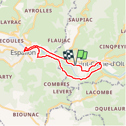
Randonnée V.T.T. de 11,8 km à découvrir à Occitanie, Aveyron, Saint-Côme-d'Olt. Cette randonnée est proposée par Strabidja.
Description
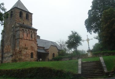
Petite boucle très sympa, qui part du château de Levinhac à St Côme d'Olt.
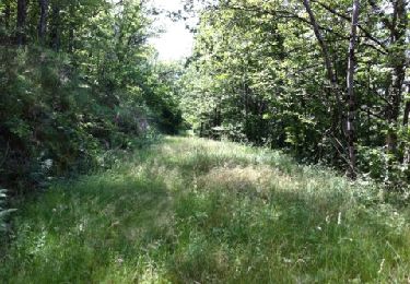
Grande partie par des petites routes, et quelques parties de sentier, chemin ou rives de la rivière, Lot.
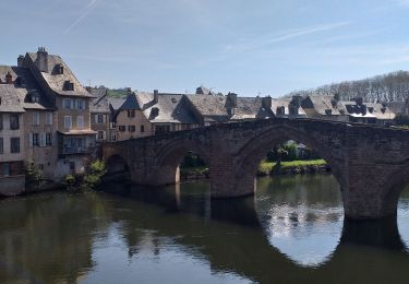
Vous passerez sur le vieux pont de St Côme d'Olt, puis suivrez une partie du GR65, chemin de St Jacques de Compostelle.
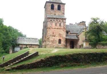
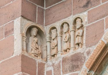
Ensuite vous trouverez sur votre route, la remarquable chapelle de Perse, pour ensuite rejoindre les rives du Lot d'où vous aurez une magnifique vue sur le vieux pont d'Espalion et son vieux palais.
Le point négatif est peut être le retour sur environ 2km sur la départementale depuis Espalion jusqu'à l'embranchement pour ; Levinhac/La Rame.
Bonne promenade à tous...
Localisation
Commentaires
Randonnées à proximité
![Randonnée Marche Espalion - Compostelle 08 - Espalion -> Estaing - Photo](https://media.geolcdn.com/t/375/260/ext.jpg?maxdim=2&url=https%3A%2F%2Fservices.sitytrail.com%2FGeolivesWS%2FDownloadMedia.ashx%3FTrailID%3D442134%26Media%3D20120624142259.jpg)
![Marche Marche](https://static1.geolcdn.com/sitytour/trail-icons/101.png)
Marche
![](/images/other/stat-length.png)
![](https://static1.geolcdn.com/siteimages/upload/files/16400158638029165_repeat_loop_refresh_sync_direction_icon.png)
![Randonnée Marche Espalion - Espalion Massip Avril 2018 - Photo](https://media.geolcdn.com/t/375/260/ext.jpg?maxdim=2&url=https%3A%2F%2Fservices.sitytrail.com%2FGeolivesWS%2FDownloadMedia.ashx%3FTrailID%3D955009%26Media%3Dfix__20180424110415.jpg)
![Marche Marche](https://static1.geolcdn.com/sitytour/trail-icons/101.png)
Marche
![](/images/other/stat-length.png)
![](https://static1.geolcdn.com/siteimages/upload/files/16400158638029165_repeat_loop_refresh_sync_direction_icon.png)
![Randonnée Marche Espalion - AVEYRON ESPARIAT O - Photo](https://media.geolcdn.com/t/375/260/4565ad9c-3f8a-44cf-88d9-f429e395cd9c.jpg&format=jpg&maxdim=2)
![Marche Marche](https://static1.geolcdn.com/sitytour/trail-icons/101.png)
Marche
![](/images/other/stat-length.png)
![](https://static1.geolcdn.com/siteimages/upload/files/16400158638029165_repeat_loop_refresh_sync_direction_icon.png)
![Randonnée Marche Saint-Côme-d'Olt - étape st Jacques st come sur d olt-estaing - Photo](https://media.geolcdn.com/t/375/260/474b24f6-c6fb-4dc7-bd61-3496ab5d9373.jpg&format=jpg&maxdim=2)
![Marche Marche](https://static1.geolcdn.com/sitytour/trail-icons/101.png)
Marche
![](/images/other/stat-length.png)
![](https://static1.geolcdn.com/siteimages/upload/files/16400158638029165_repeat_loop_refresh_sync_direction_icon.png)
![Randonnée Marche Saint-Côme-d'Olt - saint Come d'Olt Estaing - Photo](https://media.geolcdn.com/t/375/260/c7fd43f8-31b2-462b-af01-373edc4bd2c8.jpg&format=jpg&maxdim=2)
![Marche Marche](https://static1.geolcdn.com/sitytour/trail-icons/101.png)
Marche
![](/images/other/stat-length.png)
![](https://static1.geolcdn.com/siteimages/upload/files/16400158638029165_repeat_loop_refresh_sync_direction_icon.png)
![Randonnée A pied Espalion - La Voie du Rail - Photo](https://media.geolcdn.com/t/375/260/640990e0-ce63-48db-b0cb-2c1e1a59b13d.jpeg&format=jpg&maxdim=2)
![A pied A pied](https://static1.geolcdn.com/sitytour/trail-icons/100.png)
A pied
![](/images/other/stat-length.png)
![](https://static1.geolcdn.com/siteimages/upload/files/16400158638029165_repeat_loop_refresh_sync_direction_icon.png)
![Marche Marche](https://static1.geolcdn.com/sitytour/trail-icons/101.png)
Marche
![](/images/other/stat-length.png)
![](https://static1.geolcdn.com/siteimages/upload/files/16400158638029165_repeat_loop_refresh_sync_direction_icon.png)
![Randonnée Marche Saint-Côme-d'Olt - saint Côme d'olt- Estaing - Photo](https://media.geolcdn.com/t/375/260/573572db-bc00-4b76-94ac-152ed11426a7.jpg&format=jpg&maxdim=2)
![Marche Marche](https://static1.geolcdn.com/sitytour/trail-icons/101.png)
Marche
![](/images/other/stat-length.png)
![](https://static1.geolcdn.com/siteimages/upload/files/16400158638029165_repeat_loop_refresh_sync_direction_icon.png)
![Randonnée Marche Saint-Côme-d'Olt - Saint Côme d'Olt vers Estaing - Photo](https://media.geolcdn.com/t/375/260/ext.jpg?maxdim=2&url=https%3A%2F%2Fservices.sitytrail.com%2FGeolivesWS%2FDownloadMedia.ashx%3FTrailID%3D811193%26Media%3D20170816154701.jpg)
![Marche Marche](https://static1.geolcdn.com/sitytour/trail-icons/101.png)
Marche
![](/images/other/stat-length.png)
![](https://static1.geolcdn.com/siteimages/upload/files/16400158638029165_repeat_loop_refresh_sync_direction_icon.png)