![](/images/other/stat-length.png)
![Randonnée V.T.T. Lazer - Porte Sereine - Photo](https://media.geolcdn.com/t/1900/400/ext.pjpeg?maxdim=2&url=https%3A%2F%2Fstatic1.geolcdn.com%2Fsiteimages%2Fupload%2Ffiles%2F1524743154velo.jpg)
Porte Sereine
tracegps
Utilisateur
![Longueur](/images/other/stat-length.png)
![Altitude max](https://static1.geolcdn.com/siteimages/upload/files/1508320355ic_sort_altitude_max_24dp.png)
![Dénivelé positif](https://static1.geolcdn.com/siteimages/upload/files/1508320355ic_sort_den_pos_24dp.png)
![Km-Effort](/images/other/stat-length.png)
![Altitude min](https://static1.geolcdn.com/siteimages/upload/files/1508320355ic_sort_altitude_min_24dp.png)
![Dénivelé négatif](https://static1.geolcdn.com/siteimages/upload/files/1508320355ic_sort_den_neg_24dp.png)
![Boucle](https://static1.geolcdn.com/siteimages/upload/files/16400158638029165_repeat_loop_refresh_sync_direction_icon.png)
![V.T.T.](https://static1.geolcdn.com/sitytour/trail-icons/202.png)
3h00
Difficulté : Très difficile
![Scannez ce code QR pour ouvrir la randonnée dans l'application SityTrail](https://capi.geolives.com/qq0zvz2zws4bq2lad0pu/sitytour/trails/101399/qr.png?size=200)
Application GPS de randonnée GRATUITE
À propos
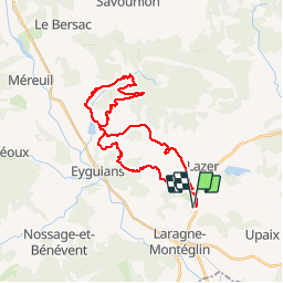
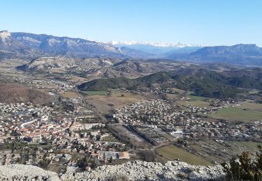
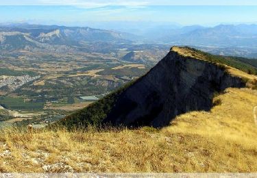
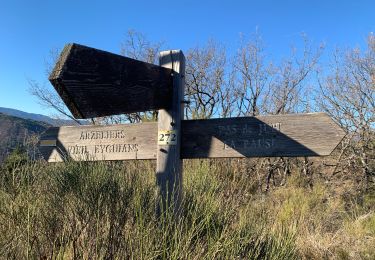
Randonnée V.T.T. de 33 km à découvrir à Provence-Alpes-Côte d'Azur, Hautes-Alpes, Lazer. Cette randonnée est proposée par tracegps.
Description
On part de Laragne Lazer, montée à Jubi par un petit raidillon bien sympa, descente de Jubi avec une "petite" marche sympa sur la fin. Ensuite montée magnifique par les gorges du Riou, puis la descente de Porte Sereine, la fameuse ! On fini par le raidillon du Viel Eygians et la descente des ruines d’Arzelier.
Localisation
Commentaires
Randonnées à proximité
![Randonnée Marche Garde-Colombe - SAINT GENIS Dep lac du Riou . Forte Sereine gorges du Riou o m s - Photo](https://media.geolcdn.com/t/375/260/56c7d25c-3fa5-4a10-abc1-3fc9cd71be7d.jpg&format=jpg&maxdim=2)
![Marche Marche](https://static1.geolcdn.com/sitytour/trail-icons/101.png)
Marche
![](/images/other/stat-length.png)
![](https://static1.geolcdn.com/siteimages/upload/files/16400158638029165_repeat_loop_refresh_sync_direction_icon.png)
![Randonnée Marche Val-Buëch-Méouge - CHATEAU NEUF DE CHABRE 05 . Piloubeau , les cretes de Chabre o s - Photo](https://media.geolcdn.com/t/375/260/ed0a937c-11c6-45f3-96a2-ba3aa0d6da41.jpg&format=jpg&maxdim=2)
![Marche Marche](https://static1.geolcdn.com/sitytour/trail-icons/101.png)
Marche
![](/images/other/stat-length.png)
![](https://static1.geolcdn.com/siteimages/upload/files/16400158638029165_repeat_loop_refresh_sync_direction_icon.png)
![Randonnée V.T.T. Laragne-Montéglin - Laragne 2008 - Photo](https://media.geolcdn.com/t/375/260/ext.jpg?maxdim=2&url=https%3A%2F%2Fstatic1.geolcdn.com%2Fsiteimages%2Fupload%2Ffiles%2F1524743154velo.jpg)
![V.T.T. V.T.T.](https://static1.geolcdn.com/sitytour/trail-icons/202.png)
V.T.T.
![](/images/other/stat-length.png)
![](https://static1.geolcdn.com/siteimages/upload/files/16400158638029165_repeat_loop_refresh_sync_direction_icon.png)
![Randonnée Marche Lazer - Le lac de Lazer par La Chapelle StJean - Photo](https://media.geolcdn.com/t/375/260/578d4a1c-7512-4632-8926-02aded433ec1.jpg&format=jpg&maxdim=2)
![Marche Marche](https://static1.geolcdn.com/sitytour/trail-icons/101.png)
Marche
![](/images/other/stat-length.png)
![](https://static1.geolcdn.com/siteimages/upload/files/16400158638029165_repeat_loop_refresh_sync_direction_icon.png)
![Randonnée sport Mison - Du lac de MISON à celui du Poet par les colombettes - Photo](https://media.geolcdn.com/t/375/260/df69e039-d0ac-423d-934e-3b88d4778692.jpg&format=jpg&maxdim=2)
sport
![](/images/other/stat-length.png)
![](https://static1.geolcdn.com/siteimages/upload/files/16400158638029165_repeat_loop_refresh_sync_direction_icon.png)
![Randonnée Marche Val-Buëch-Méouge - CHATEAU NEUF DE CHABRE . PILOUBEAU . SERRE DE LA CROIX O L M S - Photo](https://media.geolcdn.com/t/375/260/5ada7d01-3c24-447c-a90d-a06e71a0d2e2.jpg&format=jpg&maxdim=2)
![Marche Marche](https://static1.geolcdn.com/sitytour/trail-icons/101.png)
Marche
![](/images/other/stat-length.png)
![](https://static1.geolcdn.com/siteimages/upload/files/16400158638029165_repeat_loop_refresh_sync_direction_icon.png)
![Randonnée Marche Laragne-Montéglin - Vieil Arzellier/Vieil Eyguians.21/02/21. - Photo](https://media.geolcdn.com/t/375/260/addc1cc9-a190-4b69-a026-86524405f5ae.jpg&format=jpg&maxdim=2)
![Marche Marche](https://static1.geolcdn.com/sitytour/trail-icons/101.png)
Marche
![](/images/other/stat-length.png)
![](https://static1.geolcdn.com/siteimages/upload/files/16400158638029165_repeat_loop_refresh_sync_direction_icon.png)
![Randonnée Marche Val-Buëch-Méouge - R31 La Montagne de Chabre - Photo](https://media.geolcdn.com/t/375/260/ext.jpg?maxdim=2&url=https%3A%2F%2Fservices.sitytrail.com%2FGeolivesWS%2FDownloadMedia.ashx%3FTrailID%3D890890%26Media%3Db8749660-bf0d-4672-8fc8-3db6029b5cd6.jpg)
![Marche Marche](https://static1.geolcdn.com/sitytour/trail-icons/101.png)
Marche
![](/images/other/stat-length.png)
![](https://static1.geolcdn.com/siteimages/upload/files/16400158638029165_repeat_loop_refresh_sync_direction_icon.png)
![Randonnée Marche Lazer - Départ Lazer et Tour du Château d’Arzelier - Photo](https://media.geolcdn.com/t/375/260/2a914d9f-e070-4566-89b6-d5d17e8cc63d.jpg&format=jpg&maxdim=2)
![Marche Marche](https://static1.geolcdn.com/sitytour/trail-icons/101.png)
Marche
![](/images/other/stat-length.png)
![](https://static1.geolcdn.com/siteimages/upload/files/16400158638029165_repeat_loop_refresh_sync_direction_icon.png)