


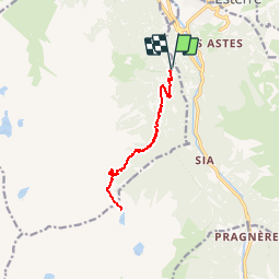


9,1 km | 18,9 km-effort

Utilisateur


Application GPS de randonnée GRATUITE
 SityTrail
IGN / Instituts géographiques
SityTrail World
Le monde est à vous
Randonnée Marche de 13 km à découvrir à Occitanie, Hautes-Pyrénées, Sazos. Cette randonnée est proposée par chasle.
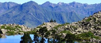
Lac de Bastampe 2019m depuis Agnouède (1058m) Le lac de Bastampe est une curiosité naturelle avec son îlot garni de pins à crochets se reflétant sur le miroir du lac. D’autres indications, photos et panoramiques sur le site « Les Pyrénées vues par Mariano ».


Marche

Marche
Marche

A pied

Marche

Marche
A pied
A pied
Marche