![](/images/other/stat-length.png)
![Randonnée Marche Castelnaud-la-Chapelle - Les Milandes - St-Cybranet - Photo](https://media.geolcdn.com/t/1900/400/ext.pjpeg?maxdim=2&url=https%3A%2F%2Fservices.sitytrail.com%2FGeolivesWS%2FDownloadMedia.ashx%3FTrailID%3D101307%26Media%3D802_1.jpg)
Les Milandes - St-Cybranet
tracegps
Utilisateur
![Longueur](/images/other/stat-length.png)
Longueur
14,2 km
![Altitude max](https://static1.geolcdn.com/siteimages/upload/files/1508320355ic_sort_altitude_max_24dp.png)
Altitude max
260 m
![Dénivelé positif](https://static1.geolcdn.com/siteimages/upload/files/1508320355ic_sort_den_pos_24dp.png)
Dénivelé positif
298 m
![Km-Effort](/images/other/stat-length.png)
Km-Effort
18,3 km
![Altitude min](https://static1.geolcdn.com/siteimages/upload/files/1508320355ic_sort_altitude_min_24dp.png)
Altitude min
76 m
![Dénivelé négatif](https://static1.geolcdn.com/siteimages/upload/files/1508320355ic_sort_den_neg_24dp.png)
Dénivelé négatif
334 m
![Boucle](https://static1.geolcdn.com/siteimages/upload/files/16400158638029165_repeat_loop_refresh_sync_direction_icon.png)
Boucle
Non
Date de création :
2014-12-10 00:00:00.0
Dernière modification :
2014-12-10 00:00:00.0
![Marche](https://static1.geolcdn.com/sitytour/trail-icons/101.png)
3h00
Difficulté : Moyen
![Scannez ce code QR pour ouvrir la randonnée dans l'application SityTrail](https://capi.geolives.com/qq0zvz2zws4bq2lad0pu/sitytour/trails/101307/qr.png?size=200)
Application GPS de randonnée GRATUITE
À propos
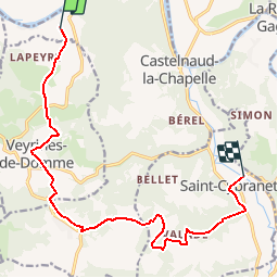
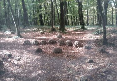
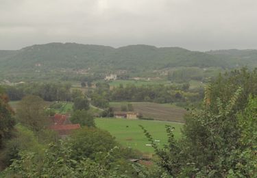
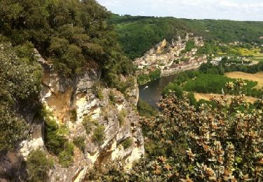
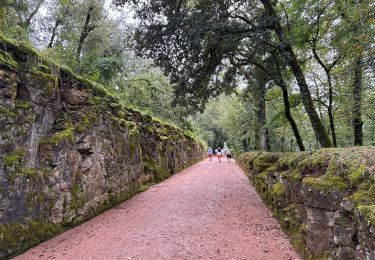
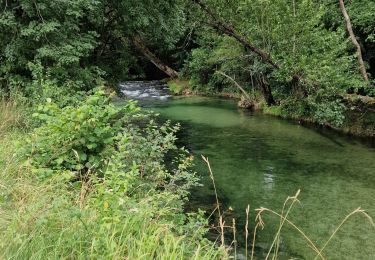
Randonnée Marche de 14,2 km à découvrir à Nouvelle-Aquitaine, Dordogne, Castelnaud-la-Chapelle. Cette randonnée est proposée par tracegps.
Description
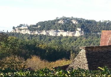
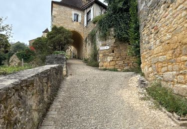
Petite balade linéaire (prévoir le retour) sur les côteaux de la vallée de la Dordogne et du Céou. D’autres infos sur le site Rando.eu Voir le site du Chateau des Milandes
Localisation
Pays :
France
Région :
Nouvelle-Aquitaine
Département/Province :
Dordogne
Commune :
Castelnaud-la-Chapelle
Localité :
Unknown
Départ:(Dec)
Départ:(UTM)
350860 ; 4965021 (31T) N.
Commentaires
Randonnées à proximité
![Randonnée Marche Castelnaud-la-Chapelle - Castelnaud 14,5km - Photo](https://media.geolcdn.com/t/375/260/ext.jpg?maxdim=2&url=https%3A%2F%2Fservices.sitytrail.com%2FGeolivesWS%2FDownloadMedia.ashx%3FTrailID%3D1066189%26Media%3Dfix__20181103150326.jpg)
![Marche Marche](https://static1.geolcdn.com/sitytour/trail-icons/101.png)
Castelnaud 14,5km
Marche
Moyen
(1)
Castelnaud-la-Chapelle,
Nouvelle-Aquitaine,
Dordogne,
France
![](/images/other/stat-length.png)
14,3 km | 18,3 km-effort
3h 41min
![](https://static1.geolcdn.com/siteimages/upload/files/16400158638029165_repeat_loop_refresh_sync_direction_icon.png)
Oui
![Randonnée Marche Castelnaud-la-Chapelle - Périgord j2 Castelnaud - Photo](https://media.geolcdn.com/t/375/260/24da01e3-51b4-4959-999d-053c9737dbd0.jpg&format=jpg&maxdim=2)
![Marche Marche](https://static1.geolcdn.com/sitytour/trail-icons/101.png)
Périgord j2 Castelnaud
Marche
Facile
Castelnaud-la-Chapelle,
Nouvelle-Aquitaine,
Dordogne,
France
![](/images/other/stat-length.png)
17,1 km | 24 km-effort
4h 38min
![](https://static1.geolcdn.com/siteimages/upload/files/16400158638029165_repeat_loop_refresh_sync_direction_icon.png)
Non
![Randonnée Marche Vézac - Boucle Beynac- La Roque Gageac - Photo](https://media.geolcdn.com/t/375/260/c8a62bb6-456c-4421-8ac7-a6b4d58db5d2.jpg&format=jpg&maxdim=2)
![Marche Marche](https://static1.geolcdn.com/sitytour/trail-icons/101.png)
Boucle Beynac- La Roque Gageac
Marche
Moyen
Vézac,
Nouvelle-Aquitaine,
Dordogne,
France
![](/images/other/stat-length.png)
16,3 km | 22 km-effort
4h 20min
![](https://static1.geolcdn.com/siteimages/upload/files/16400158638029165_repeat_loop_refresh_sync_direction_icon.png)
Oui
![Randonnée Marche Beynac-et-Cazenac - Beynac-et-Cazenac - 16.3km 460m 4h05 (30mn) - 2013 07 27 - Photo](https://media.geolcdn.com/t/375/260/a861afd5-735a-473e-a5f1-3f79378bc8ab.jpg&format=jpg&maxdim=2)
![Marche Marche](https://static1.geolcdn.com/sitytour/trail-icons/101.png)
Beynac-et-Cazenac - 16.3km 460m 4h05 (30mn) - 2013 07 27
Marche
Moyen
Beynac-et-Cazenac,
Nouvelle-Aquitaine,
Dordogne,
France
![](/images/other/stat-length.png)
16,3 km | 22 km-effort
4h 5min
![](https://static1.geolcdn.com/siteimages/upload/files/16400158638029165_repeat_loop_refresh_sync_direction_icon.png)
Oui
![Randonnée Moteur Vézac - Jardin du château de Marquesac - Photo](https://media.geolcdn.com/t/375/260/ext.jpg?maxdim=2&url=https%3A%2F%2Fservices.sitytrail.com%2FGeolivesWS%2FDownloadMedia.ashx%3FTrailID%3D347730%26Media%3Dfix__20140923141715.jpg)
![Moteur Moteur](https://static1.geolcdn.com/sitytour/trail-icons/400.png)
Jardin du château de Marquesac
Moteur
Très difficile
Vézac,
Nouvelle-Aquitaine,
Dordogne,
France
![](/images/other/stat-length.png)
5,3 km | 6,8 km-effort
4h 19min
![](https://static1.geolcdn.com/siteimages/upload/files/16400158638029165_repeat_loop_refresh_sync_direction_icon.png)
Oui
![Randonnée Marche Castelnaud-la-Chapelle - Balade autour de Castelnaud la Chapelle - Photo](https://media.geolcdn.com/t/375/260/ext.jpg?maxdim=2&url=https%3A%2F%2Fservices.sitytrail.com%2FGeolivesWS%2FDownloadMedia.ashx%3FTrailID%3D172935%26Media%3D14412_3.jpg)
![Marche Marche](https://static1.geolcdn.com/sitytour/trail-icons/101.png)
Balade autour de Castelnaud la Chapelle
Marche
Moyen
Castelnaud-la-Chapelle,
Nouvelle-Aquitaine,
Dordogne,
France
![](/images/other/stat-length.png)
13,5 km | 19 km-effort
3h 30min
![](https://static1.geolcdn.com/siteimages/upload/files/16400158638029165_repeat_loop_refresh_sync_direction_icon.png)
Oui
![Randonnée Marche Vézac - 2011-06-03 - 17h56m53 - Photo](https://media.geolcdn.com/t/375/260/ext.jpg?maxdim=2&url=https%3A%2F%2Fservices.sitytrail.com%2FGeolivesWS%2FDownloadMedia.ashx%3FTrailID%3D67099%26Media%3D20110603154850.jpg)
![Marche Marche](https://static1.geolcdn.com/sitytour/trail-icons/101.png)
2011-06-03 - 17h56m53
Marche
Très facile
(1)
Vézac,
Nouvelle-Aquitaine,
Dordogne,
France
![](/images/other/stat-length.png)
1,2 km | 1,8 km-effort
Inconnu
![](https://static1.geolcdn.com/siteimages/upload/files/16400158638029165_repeat_loop_refresh_sync_direction_icon.png)
Oui
![Randonnée Marche Vézac - Château de Marqueyssac - Photo](https://media.geolcdn.com/t/375/260/b9e15253-79a4-442d-a1c8-a27b8cf42b2d.jpg&format=jpg&maxdim=2)
![Marche Marche](https://static1.geolcdn.com/sitytour/trail-icons/101.png)
Château de Marqueyssac
Marche
Vézac,
Nouvelle-Aquitaine,
Dordogne,
France
![](/images/other/stat-length.png)
3,1 km | 4,1 km-effort
53min
![](https://static1.geolcdn.com/siteimages/upload/files/16400158638029165_repeat_loop_refresh_sync_direction_icon.png)
Non
![Randonnée V.T.C. Castelnaud-la-Chapelle - Castelnaud à l'abbaye Nouvelle et retour (Dordogne) - Photo](https://media.geolcdn.com/t/375/260/9e35bcb8-43a7-463b-b578-7314281c2612.jpg&format=jpg&maxdim=2)
![V.T.C. V.T.C.](https://static1.geolcdn.com/sitytour/trail-icons/203.png)
Castelnaud à l'abbaye Nouvelle et retour (Dordogne)
V.T.C.
Très difficile
Castelnaud-la-Chapelle,
Nouvelle-Aquitaine,
Dordogne,
France
![](/images/other/stat-length.png)
53 km | 62 km-effort
6h 19min
![](https://static1.geolcdn.com/siteimages/upload/files/16400158638029165_repeat_loop_refresh_sync_direction_icon.png)
Oui