![](/images/other/stat-length.png)
![Randonnée V.T.T. Cubières - GTMC de Claire - 7 - Photo](https://media.geolcdn.com/t/1900/400/ext.pjpeg?maxdim=2&url=https%3A%2F%2Fservices.sitytrail.com%2FGeolivesWS%2FDownloadMedia.ashx%3FTrailID%3D101273%26Media%3D760_1.jpg)
GTMC de Claire - 7
tracegps
Utilisateur
![Longueur](/images/other/stat-length.png)
Longueur
75 km
![Altitude max](https://static1.geolcdn.com/siteimages/upload/files/1508320355ic_sort_altitude_max_24dp.png)
Altitude max
1547 m
![Dénivelé positif](https://static1.geolcdn.com/siteimages/upload/files/1508320355ic_sort_den_pos_24dp.png)
Dénivelé positif
1258 m
![Km-Effort](/images/other/stat-length.png)
Km-Effort
95 km
![Altitude min](https://static1.geolcdn.com/siteimages/upload/files/1508320355ic_sort_altitude_min_24dp.png)
Altitude min
470 m
![Dénivelé négatif](https://static1.geolcdn.com/siteimages/upload/files/1508320355ic_sort_den_neg_24dp.png)
Dénivelé négatif
2241 m
![Boucle](https://static1.geolcdn.com/siteimages/upload/files/16400158638029165_repeat_loop_refresh_sync_direction_icon.png)
Boucle
Non
Date de création :
2014-12-10 00:00:00.0
Dernière modification :
2014-12-10 00:00:00.0
![V.T.T.](https://static1.geolcdn.com/sitytour/trail-icons/202.png)
5h00
Difficulté : Très difficile
![Scannez ce code QR pour ouvrir la randonnée dans l'application SityTrail](https://capi.geolives.com/qq0zvz2zws4bq2lad0pu/sitytour/trails/101273/qr.png?size=200)
Application GPS de randonnée GRATUITE
À propos
Randonnée V.T.T. de 75 km à découvrir à Occitanie, Lozère, Cubières. Cette randonnée est proposée par tracegps.
Description
La Grande Traversée du Massif Central par Claire et ses amis. En douze étapes, revivez cette aventure sur son site. Septième étape: mardi 08 Août 2006. Retrouvez le résumé de la journée, les conseils et les photos ICI
Localisation
Pays :
France
Région :
Occitanie
Département/Province :
Lozère
Commune :
Cubières
Localité :
Unknown
Départ:(Dec)
Départ:(UTM)
559584 ; 4921551 (31T) N.
Commentaires
Randonnées à proximité
![Randonnée V.T.T. Cubières - TOUR MONT LOZERE - Photo](https://media.geolcdn.com/t/375/260/a1bfdb58-8337-4d84-b53e-6cb2f940b716.jpeg&format=jpg&maxdim=2)
![V.T.T. V.T.T.](https://static1.geolcdn.com/sitytour/trail-icons/202.png)
TOUR MONT LOZERE
V.T.T.
Très difficile
(1)
Cubières,
Occitanie,
Lozère,
France
![](/images/other/stat-length.png)
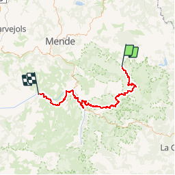
38 km | 47 km-effort
3h 14min
![](https://static1.geolcdn.com/siteimages/upload/files/16400158638029165_repeat_loop_refresh_sync_direction_icon.png)
Oui
![Marche Marche](https://static1.geolcdn.com/sitytour/trail-icons/101.png)
Les prairies du col de Finiels et des monts Lozere
Marche
Moyen
(1)
Mont Lozère et Goulet,
Occitanie,
Lozère,
France
![](/images/other/stat-length.png)
7,2 km | 9,5 km-effort
2h 59min
![](https://static1.geolcdn.com/siteimages/upload/files/16400158638029165_repeat_loop_refresh_sync_direction_icon.png)
Oui
![Randonnée Marche Mont Lozère et Goulet - Bleymar _ Le Pont Montvert - Photo](https://media.geolcdn.com/t/375/260/ext.jpg?maxdim=2&url=https%3A%2F%2Fservices.sitytrail.com%2FGeolivesWS%2FDownloadMedia.ashx%3FTrailID%3D463465%26Media%3Dfix__20150819092348.jpg)
![Marche Marche](https://static1.geolcdn.com/sitytour/trail-icons/101.png)
Bleymar _ Le Pont Montvert
Marche
Difficile
(1)
Mont Lozère et Goulet,
Occitanie,
Lozère,
France
![](/images/other/stat-length.png)
22 km | 32 km-effort
5h 19min
![](https://static1.geolcdn.com/siteimages/upload/files/16400158638029165_repeat_loop_refresh_sync_direction_icon.png)
Non
![Randonnée Marche Mont Lozère et Goulet - Chemin de Stevenson - Le Bleymard vers Le Pont de Montvert - Photo](https://media.geolcdn.com/t/375/260/ext.jpg?maxdim=2&url=https%3A%2F%2Fservices.sitytrail.com%2FGeolivesWS%2FDownloadMedia.ashx%3FTrailID%3D109272%26Media%3D3392_1.jpg)
![Marche Marche](https://static1.geolcdn.com/sitytour/trail-icons/101.png)
Chemin de Stevenson - Le Bleymard vers Le Pont de Montvert
Marche
Difficile
(1)
Mont Lozère et Goulet,
Occitanie,
Lozère,
France
![](/images/other/stat-length.png)
18,9 km | 28 km-effort
4h 30min
![](https://static1.geolcdn.com/siteimages/upload/files/16400158638029165_repeat_loop_refresh_sync_direction_icon.png)
Non
![Randonnée Marche Pont de Montvert - Sud Mont Lozère - Finiels/ sommet / station du Bleymard en boucle - Photo](https://media.geolcdn.com/t/375/260/f8048304-3a05-4fd0-a0e7-03457722fcee.jpg&format=jpg&maxdim=2)
![Marche Marche](https://static1.geolcdn.com/sitytour/trail-icons/101.png)
Finiels/ sommet / station du Bleymard en boucle
Marche
Difficile
Pont de Montvert - Sud Mont Lozère,
Occitanie,
Lozère,
France
![](/images/other/stat-length.png)
20 km | 30 km-effort
5h 38min
![](https://static1.geolcdn.com/siteimages/upload/files/16400158638029165_repeat_loop_refresh_sync_direction_icon.png)
Oui
![Randonnée Marche Mont Lozère et Goulet - Stevenson étape 8 - Photo](https://media.geolcdn.com/t/375/260/b34e09af-9026-4127-8636-d1e451b59807.jpg&format=jpg&maxdim=2)
![Marche Marche](https://static1.geolcdn.com/sitytour/trail-icons/101.png)
Stevenson étape 8
Marche
Difficile
Mont Lozère et Goulet,
Occitanie,
Lozère,
France
![](/images/other/stat-length.png)
20 km | 30 km-effort
5h 29min
![](https://static1.geolcdn.com/siteimages/upload/files/16400158638029165_repeat_loop_refresh_sync_direction_icon.png)
Non
![Randonnée Marche Mont Lozère et Goulet - sources du tarn - Photo](https://media.geolcdn.com/t/375/260/ext.jpg?maxdim=2&url=https%3A%2F%2Fstatic1.geolcdn.com%2Fsiteimages%2Fupload%2Ffiles%2F1553511878bg_sport_marche.png)
![Marche Marche](https://static1.geolcdn.com/sitytour/trail-icons/101.png)
sources du tarn
Marche
Moyen
(1)
Mont Lozère et Goulet,
Occitanie,
Lozère,
France
![](/images/other/stat-length.png)
13,3 km | 17,3 km-effort
3h 50min
![](https://static1.geolcdn.com/siteimages/upload/files/16400158638029165_repeat_loop_refresh_sync_direction_icon.png)
Non
![Randonnée Vélo électrique Cubières - ETANG DE BARANDON PAR LA STATION DE SKI - Photo](https://media.geolcdn.com/t/375/260/02cfb49c-be69-4aa6-8d1f-cab2e83a60e7.jpeg&format=jpg&maxdim=2)
![Vélo électrique Vélo électrique](https://static1.geolcdn.com/sitytour/trail-icons/205.png)
ETANG DE BARANDON PAR LA STATION DE SKI
Vélo électrique
Moyen
Cubières,
Occitanie,
Lozère,
France
![](/images/other/stat-length.png)
31 km | 36 km-effort
2h 11min
![](https://static1.geolcdn.com/siteimages/upload/files/16400158638029165_repeat_loop_refresh_sync_direction_icon.png)
Oui
![Randonnée Marche Mont Lozère et Goulet - Pont de Montvert - Photo](https://media.geolcdn.com/t/375/260/ef737a4f-a7c1-4642-affe-b45fe92c561f.jpg&format=jpg&maxdim=2)
![Marche Marche](https://static1.geolcdn.com/sitytour/trail-icons/101.png)
Pont de Montvert
Marche
Très difficile
Mont Lozère et Goulet,
Occitanie,
Lozère,
France
![](/images/other/stat-length.png)
19,4 km | 29 km-effort
6h 52min
![](https://static1.geolcdn.com/siteimages/upload/files/16400158638029165_repeat_loop_refresh_sync_direction_icon.png)
Non