![](/images/other/stat-length.png)
![Randonnée Marche Saint-Sozy - St-Sozy - Photo](https://media.geolcdn.com/t/1900/400/ext.pjpeg?maxdim=2&url=https%3A%2F%2Fservices.sitytrail.com%2FGeolivesWS%2FDownloadMedia.ashx%3FTrailID%3D101248%26Media%3D736_1.jpg)
St-Sozy
tracegps
Utilisateur
![Longueur](/images/other/stat-length.png)
Longueur
8 km
![Altitude max](https://static1.geolcdn.com/siteimages/upload/files/1508320355ic_sort_altitude_max_24dp.png)
Altitude max
240 m
![Dénivelé positif](https://static1.geolcdn.com/siteimages/upload/files/1508320355ic_sort_den_pos_24dp.png)
Dénivelé positif
301 m
![Km-Effort](/images/other/stat-length.png)
Km-Effort
12 km
![Altitude min](https://static1.geolcdn.com/siteimages/upload/files/1508320355ic_sort_altitude_min_24dp.png)
Altitude min
98 m
![Dénivelé négatif](https://static1.geolcdn.com/siteimages/upload/files/1508320355ic_sort_den_neg_24dp.png)
Dénivelé négatif
305 m
![Boucle](https://static1.geolcdn.com/siteimages/upload/files/16400158638029165_repeat_loop_refresh_sync_direction_icon.png)
Boucle
Oui
Date de création :
2014-12-10 00:00:00.0
Dernière modification :
2014-12-10 00:00:00.0
![Marche](https://static1.geolcdn.com/sitytour/trail-icons/101.png)
2h00
Difficulté : Moyen
![Scannez ce code QR pour ouvrir la randonnée dans l'application SityTrail](https://capi.geolives.com/qq0zvz2zws4bq2lad0pu/sitytour/trails/101248/qr.png?size=200)
Application GPS de randonnée GRATUITE
À propos
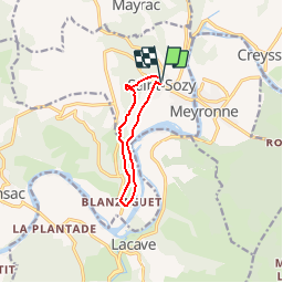
Randonnée Marche de 8 km à découvrir à Occitanie, Lot, Saint-Sozy. Cette randonnée est proposée par tracegps.
Description
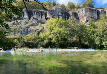
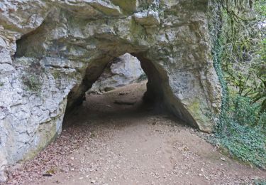
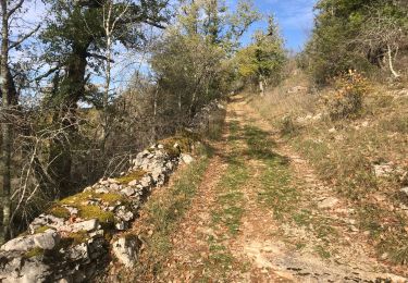
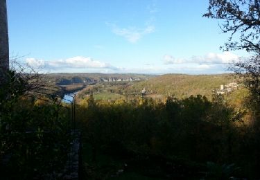
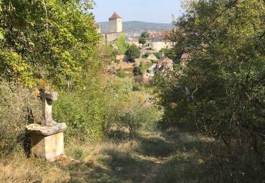
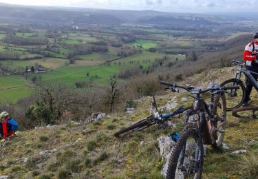
Petite boucle considéré comme "sportive", la montée sur les falaises est la portion la plus difficile mais la beauté du paysage sur la vallée de la Dordogne nous fait vite oublier les efforts fournis. D'autres infos et conseils sur Rando.eu
Localisation
Pays :
France
Région :
Occitanie
Département/Province :
Lot
Commune :
Saint-Sozy
Localité :
Unknown
Départ:(Dec)
Départ:(UTM)
386664 ; 4970683 (31T) N.
Commentaires
Randonnées à proximité
![Randonnée Vélo électrique Martel - Gluges Rocamadour - Photo](https://media.geolcdn.com/t/375/260/51ee3a9d-6cae-4df3-9457-785f412c8afb.jpg&format=jpg&maxdim=2)
![Vélo électrique Vélo électrique](https://static1.geolcdn.com/sitytour/trail-icons/205.png)
Gluges Rocamadour
Vélo électrique
Facile
Martel,
Occitanie,
Lot,
France
![](/images/other/stat-length.png)
53 km | 64 km-effort
4h 22min
![](https://static1.geolcdn.com/siteimages/upload/files/16400158638029165_repeat_loop_refresh_sync_direction_icon.png)
Oui
![Randonnée A pied Lacave - Gouffre et résurgence du Limon - Grottes de Lacave - Photo](https://media.geolcdn.com/t/375/260/5e412449-e7ae-48cd-a409-15fba403aaf0.jpeg&format=jpg&maxdim=2)
![A pied A pied](https://static1.geolcdn.com/sitytour/trail-icons/100.png)
Gouffre et résurgence du Limon - Grottes de Lacave
A pied
Facile
Lacave,
Occitanie,
Lot,
France
![](/images/other/stat-length.png)
14,4 km | 19,6 km-effort
4h 26min
![](https://static1.geolcdn.com/siteimages/upload/files/16400158638029165_repeat_loop_refresh_sync_direction_icon.png)
Oui
![Marche Marche](https://static1.geolcdn.com/sitytour/trail-icons/101.png)
Saint Sozy -
Marche
Très difficile
Saint-Sozy,
Occitanie,
Lot,
France
![](/images/other/stat-length.png)
13,8 km | 20 km-effort
4h 15min
![](https://static1.geolcdn.com/siteimages/upload/files/16400158638029165_repeat_loop_refresh_sync_direction_icon.png)
Oui
![Randonnée Marche Montvalent - Bendou - Photo](https://media.geolcdn.com/t/375/260/1f118c9d-c875-42a8-9261-fa2db7214a23.jpg&format=jpg&maxdim=2)
![Marche Marche](https://static1.geolcdn.com/sitytour/trail-icons/101.png)
![Randonnée Marche Montvalent - Causse toujours - Photo](https://media.geolcdn.com/t/375/260/ext.jpg?maxdim=2&url=https%3A%2F%2Fservices.sitytrail.com%2FGeolivesWS%2FDownloadMedia.ashx%3FTrailID%3D162313%26Media%3D20121111160303.jpeg)
![Marche Marche](https://static1.geolcdn.com/sitytour/trail-icons/101.png)
Causse toujours
Marche
Difficile
Montvalent,
Occitanie,
Lot,
France
![](/images/other/stat-length.png)
17,2 km | 23 km-effort
4h 30min
![](https://static1.geolcdn.com/siteimages/upload/files/16400158638029165_repeat_loop_refresh_sync_direction_icon.png)
Oui
![Randonnée Marche Lacave - Pont de l'Ouysse Cougnaguet - Photo](https://media.geolcdn.com/t/375/260/6ad3f641-1c09-416e-82b8-fe55c94adfa1.jpg&format=jpg&maxdim=2)
![Marche Marche](https://static1.geolcdn.com/sitytour/trail-icons/101.png)
Pont de l'Ouysse Cougnaguet
Marche
Très facile
Lacave,
Occitanie,
Lot,
France
![](/images/other/stat-length.png)
13,9 km | 16,5 km-effort
3h 32min
![](https://static1.geolcdn.com/siteimages/upload/files/16400158638029165_repeat_loop_refresh_sync_direction_icon.png)
Oui
![Randonnée Marche Montvalent - Montvalent - Photo](https://media.geolcdn.com/t/375/260/768cc970-5825-433c-b875-fe9558a0406e.jpg&format=jpg&maxdim=2)
![Marche Marche](https://static1.geolcdn.com/sitytour/trail-icons/101.png)
![Randonnée V.T.T. Martel - Gluges- Gluges par St Sozy, Pinsac, Lacave, Meyronne, Creysse. - Photo](https://media.geolcdn.com/t/375/260/7f11c020-5173-4557-9086-8eec92a59d6e.jpg&format=jpg&maxdim=2)
![V.T.T. V.T.T.](https://static1.geolcdn.com/sitytour/trail-icons/202.png)
Gluges- Gluges par St Sozy, Pinsac, Lacave, Meyronne, Creysse.
V.T.T.
Très difficile
(1)
Martel,
Occitanie,
Lot,
France
![](/images/other/stat-length.png)
35 km | 45 km-effort
3h 23min
![](https://static1.geolcdn.com/siteimages/upload/files/16400158638029165_repeat_loop_refresh_sync_direction_icon.png)
Oui
![Randonnée Marche Saint-Sozy - Saint Sozy - Photo](https://media.geolcdn.com/t/375/260/2ef15c36-d80b-43a9-b3f9-01f11da15a9a.jpg&format=jpg&maxdim=2)
![Marche Marche](https://static1.geolcdn.com/sitytour/trail-icons/101.png)
Belle rando mais nous avons perdu le chemin à 2 reprises dans la 1ère montée.
attention au départ prendre la déviation 2011 conseillée sinon galère
très belles vues