![](/images/other/stat-length.png)
![Randonnée V.T.T. Hindisheim - Le Long des Canaux - Photo](https://media.geolcdn.com/t/1900/400/ext.pjpeg?maxdim=2&url=https%3A%2F%2Fservices.sitytrail.com%2FGeolivesWS%2FDownloadMedia.ashx%3FTrailID%3D101176%26Media%3D663_1.jpg)
Le Long des Canaux
tracegps
Utilisateur
![Longueur](/images/other/stat-length.png)
![Altitude max](https://static1.geolcdn.com/siteimages/upload/files/1508320355ic_sort_altitude_max_24dp.png)
![Dénivelé positif](https://static1.geolcdn.com/siteimages/upload/files/1508320355ic_sort_den_pos_24dp.png)
![Km-Effort](/images/other/stat-length.png)
![Altitude min](https://static1.geolcdn.com/siteimages/upload/files/1508320355ic_sort_altitude_min_24dp.png)
![Dénivelé négatif](https://static1.geolcdn.com/siteimages/upload/files/1508320355ic_sort_den_neg_24dp.png)
![Boucle](https://static1.geolcdn.com/siteimages/upload/files/16400158638029165_repeat_loop_refresh_sync_direction_icon.png)
![V.T.T.](https://static1.geolcdn.com/sitytour/trail-icons/202.png)
2h00
Difficulté : Difficile
![Scannez ce code QR pour ouvrir la randonnée dans l'application SityTrail](https://capi.geolives.com/qq0zvz2zws4bq2lad0pu/sitytour/trails/101176/qr.png?size=200)
Application GPS de randonnée GRATUITE
À propos
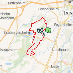
Randonnée V.T.T. de 23 km à découvrir à Grand Est, Bas-Rhin, Hindisheim. Cette randonnée est proposée par tracegps.
Description
Ce circuit vous emmènera dans le Bruch entre Hindisheim et Krautergersheim le long des canaux d'irrigation. A l'instar des balises CV dans les Vosges, ce sont eux qui vous guideront le long de ce parcours. Notez que circuit est difficile du fait du manque de repère pour s'orienter. Trouver les petits sentiers le long des cours d'eau peut être fortement entravé par la végétation en été. De plus, le Bruch étant considéré comme un marécage, attendez-vous à avoir les pieds mouillés après la pluie. La première difficulté d'orientation réside dans le fait de trouver la première passerelle pour traverser l'Ergelsenbach après avoir longé le Schiffbach. Soyez attentif au fait que le chemin principal vire brusquement vers la gauche. A cet endroit, vous devrez le quitter sur la droite. La passerelle en question se trouve environ 40m à l'Ouest. Environ 25m plus loin se situe la deuxième passerelle sur le Schiffbach. Traversez-la et longez le cours d'eau. Attention, là aussi le chemin principal s'éloigne de celui-ci. Ne le suivez pas, restez sur la rive pour rejoindre la D161..... la suite et d'autres infos sont ICI
Localisation
Commentaires
Randonnées à proximité
![Randonnée A pied Blaesheim - Parcours de Hattisheim - Photo](https://media.geolcdn.com/t/375/260/46804a8f-a8ba-49b7-b576-01d356b3c166.jpeg&format=jpg&maxdim=2)
![A pied A pied](https://static1.geolcdn.com/sitytour/trail-icons/100.png)
A pied
![](/images/other/stat-length.png)
![](https://static1.geolcdn.com/siteimages/upload/files/16400158638029165_repeat_loop_refresh_sync_direction_icon.png)
![Randonnée Marche Nordhouse - 2023/04/23 L'Ill et l'écluse 81 par champs et forêt - Photo](https://media.geolcdn.com/t/375/260/8f22c99b-08cb-42eb-a633-54d741331c03.jpg&format=jpg&maxdim=2)
![Marche Marche](https://static1.geolcdn.com/sitytour/trail-icons/101.png)
Marche
![](/images/other/stat-length.png)
![](https://static1.geolcdn.com/siteimages/upload/files/16400158638029165_repeat_loop_refresh_sync_direction_icon.png)
![Randonnée Marche Hindisheim - HINDISHEIM autour de l'Andlau - Photo](https://media.geolcdn.com/t/375/260/8813bd15-650a-4ef5-804a-ebcfe39ce36f.jpg&format=jpg&maxdim=2)
![Marche Marche](https://static1.geolcdn.com/sitytour/trail-icons/101.png)
Marche
![](/images/other/stat-length.png)
![](https://static1.geolcdn.com/siteimages/upload/files/16400158638029165_repeat_loop_refresh_sync_direction_icon.png)
![Randonnée A pied Fegersheim - Tour de FEGERSHEIM OHNHEIM ESCHAU - Photo](https://media.geolcdn.com/t/375/260/002aca80-1410-4801-b554-ed0f1063deb8.jpeg&format=jpg&maxdim=2)
![A pied A pied](https://static1.geolcdn.com/sitytour/trail-icons/100.png)
A pied
![](/images/other/stat-length.png)
![](https://static1.geolcdn.com/siteimages/upload/files/16400158638029165_repeat_loop_refresh_sync_direction_icon.png)
![Randonnée Marche Innenheim - 2022-01-23-Le Gloeckelsberg et La Chapelle du Loup - Photo](https://media.geolcdn.com/t/375/260/fa3533b8-ce51-43eb-95b1-3cc8dfcdca79.jpg&format=jpg&maxdim=2)
![Marche Marche](https://static1.geolcdn.com/sitytour/trail-icons/101.png)
Marche
![](/images/other/stat-length.png)
![](https://static1.geolcdn.com/siteimages/upload/files/16400158638029165_repeat_loop_refresh_sync_direction_icon.png)
![Randonnée V.T.T. Hindisheim - Le Tour des Etangs - Photo](https://media.geolcdn.com/t/375/260/ext.jpg?maxdim=2&url=https%3A%2F%2Fservices.sitytrail.com%2FGeolivesWS%2FDownloadMedia.ashx%3FTrailID%3D101178%26Media%3D665_1.jpg)
![V.T.T. V.T.T.](https://static1.geolcdn.com/sitytour/trail-icons/202.png)
V.T.T.
![](/images/other/stat-length.png)
![](https://static1.geolcdn.com/siteimages/upload/files/16400158638029165_repeat_loop_refresh_sync_direction_icon.png)
![Randonnée V.T.T. Nordhouse - Circuit entre les Ill - Photo](https://media.geolcdn.com/t/375/260/ext.jpg?maxdim=2&url=https%3A%2F%2Fservices.sitytrail.com%2FGeolivesWS%2FDownloadMedia.ashx%3FTrailID%3D101175%26Media%3D662_1.jpg)
![V.T.T. V.T.T.](https://static1.geolcdn.com/sitytour/trail-icons/202.png)
V.T.T.
![](/images/other/stat-length.png)
![](https://static1.geolcdn.com/siteimages/upload/files/16400158638029165_repeat_loop_refresh_sync_direction_icon.png)
![Randonnée V.T.T. Hindisheim - Le Tour du Bruch de l'Andlau - Photo](https://media.geolcdn.com/t/375/260/ext.jpg?maxdim=2&url=https%3A%2F%2Fservices.sitytrail.com%2FGeolivesWS%2FDownloadMedia.ashx%3FTrailID%3D101174%26Media%3D661_1.jpg)
![V.T.T. V.T.T.](https://static1.geolcdn.com/sitytour/trail-icons/202.png)
V.T.T.
![](/images/other/stat-length.png)
![](https://static1.geolcdn.com/siteimages/upload/files/16400158638029165_repeat_loop_refresh_sync_direction_icon.png)
![Randonnée V.T.T. Hindisheim - Circuit du Sentier de la Chapelle - Photo](https://media.geolcdn.com/t/375/260/ext.jpg?maxdim=2&url=https%3A%2F%2Fservices.sitytrail.com%2FGeolivesWS%2FDownloadMedia.ashx%3FTrailID%3D101059%26Media%3D550_1.jpg)
![V.T.T. V.T.T.](https://static1.geolcdn.com/sitytour/trail-icons/202.png)
V.T.T.
![](/images/other/stat-length.png)
![](https://static1.geolcdn.com/siteimages/upload/files/16400158638029165_repeat_loop_refresh_sync_direction_icon.png)
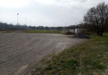
beaucoup de chemins en forêt ne sont plus praticables. Sinon ballade sympa