![](/images/other/stat-length.png)
![Randonnée V.T.T. Wangenbourg-Engenthal - Circuit de la Mossig - Photo](https://media.geolcdn.com/t/1900/400/ext.pjpeg?maxdim=2&url=https%3A%2F%2Fservices.sitytrail.com%2FGeolivesWS%2FDownloadMedia.ashx%3FTrailID%3D101112%26Media%3D603_1.jpg)
Circuit de la Mossig
tracegps
Utilisateur
![Longueur](/images/other/stat-length.png)
Longueur
19,7 km
![Altitude max](https://static1.geolcdn.com/siteimages/upload/files/1508320355ic_sort_altitude_max_24dp.png)
Altitude max
481 m
![Dénivelé positif](https://static1.geolcdn.com/siteimages/upload/files/1508320355ic_sort_den_pos_24dp.png)
Dénivelé positif
499 m
![Km-Effort](/images/other/stat-length.png)
Km-Effort
26 km
![Altitude min](https://static1.geolcdn.com/siteimages/upload/files/1508320355ic_sort_altitude_min_24dp.png)
Altitude min
293 m
![Dénivelé négatif](https://static1.geolcdn.com/siteimages/upload/files/1508320355ic_sort_den_neg_24dp.png)
Dénivelé négatif
499 m
![Boucle](https://static1.geolcdn.com/siteimages/upload/files/16400158638029165_repeat_loop_refresh_sync_direction_icon.png)
Boucle
Oui
Date de création :
2014-12-10 00:00:00.0
Dernière modification :
2014-12-10 00:00:00.0
![V.T.T.](https://static1.geolcdn.com/sitytour/trail-icons/202.png)
1h30
Difficulté : Moyen
![Scannez ce code QR pour ouvrir la randonnée dans l'application SityTrail](https://capi.geolives.com/qq0zvz2zws4bq2lad0pu/sitytour/trails/101112/qr.png?size=200)
Application GPS de randonnée GRATUITE
À propos
Randonnée V.T.T. de 19,7 km à découvrir à Grand Est, Bas-Rhin, Wangenbourg-Engenthal. Cette randonnée est proposée par tracegps.
Description
Ce circuit démarre par de la descente au départ d'Obersteigen.Les chemins sont larges, stabilisés ( sauf lors de la première montée ) et dégagés de tout arbre. Aucune difficultés particulières à signaler. Le balisage est en bon état. A voir ICI
Localisation
Pays :
France
Région :
Grand Est
Département/Province :
Bas-Rhin
Commune :
Wangenbourg-Engenthal
Localité :
Unknown
Départ:(Dec)
Départ:(UTM)
375219 ; 5388990 (32U) N.
Commentaires
Randonnées à proximité
![Randonnée Marche Reinhardsmunster - 2021-09-01 Marche Reinhardsmunster Haut Barr - Photo](https://media.geolcdn.com/t/375/260/266b2ac9-dd10-4dc7-a762-c9d36720cc88.jpg&format=jpg&maxdim=2)
![Marche Marche](https://static1.geolcdn.com/sitytour/trail-icons/101.png)
2021-09-01 Marche Reinhardsmunster Haut Barr
Marche
Très difficile
Reinhardsmunster,
Grand Est,
Bas-Rhin,
France
![](/images/other/stat-length.png)
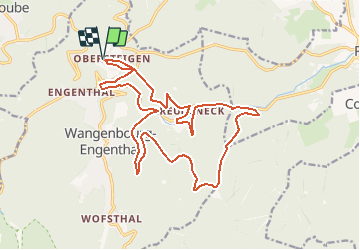
21 km | 32 km-effort
6h 39min
![](https://static1.geolcdn.com/siteimages/upload/files/16400158638029165_repeat_loop_refresh_sync_direction_icon.png)
Oui
![Randonnée Marche Reinhardsmunster - 2020-06-13 Marche Ditschelkopf Schweizerberg - Photo](https://media.geolcdn.com/t/375/260/d6670ae9-2bf3-459d-a4b8-1c117627d287.jpg&format=jpg&maxdim=2)
![Marche Marche](https://static1.geolcdn.com/sitytour/trail-icons/101.png)
2020-06-13 Marche Ditschelkopf Schweizerberg
Marche
Très facile
Reinhardsmunster,
Grand Est,
Bas-Rhin,
France
![](/images/other/stat-length.png)
14,5 km | 22 km-effort
4h 52min
![](https://static1.geolcdn.com/siteimages/upload/files/16400158638029165_repeat_loop_refresh_sync_direction_icon.png)
Oui
![Randonnée Marche Wangenbourg-Engenthal - 2020-03-14 Marche Engenthal le bas - Photo](https://media.geolcdn.com/t/375/260/ba70735c-7023-4458-a456-f43a6f2e7606.jpg&format=jpg&maxdim=2)
![Marche Marche](https://static1.geolcdn.com/sitytour/trail-icons/101.png)
2020-03-14 Marche Engenthal le bas
Marche
Très facile
Wangenbourg-Engenthal,
Grand Est,
Bas-Rhin,
France
![](/images/other/stat-length.png)
14,3 km | 22 km-effort
4h 27min
![](https://static1.geolcdn.com/siteimages/upload/files/16400158638029165_repeat_loop_refresh_sync_direction_icon.png)
Oui
![Randonnée Marche Wangenbourg-Engenthal - 2019-11-16 Marche Wangenbourg Castelberg - Photo](https://media.geolcdn.com/t/375/260/5fe565fb-6e88-4bed-a889-a75a33bb061a.jpg&format=jpg&maxdim=2)
![Marche Marche](https://static1.geolcdn.com/sitytour/trail-icons/101.png)
2019-11-16 Marche Wangenbourg Castelberg
Marche
Très facile
Wangenbourg-Engenthal,
Grand Est,
Bas-Rhin,
France
![](/images/other/stat-length.png)
19,8 km | 31 km-effort
4h 51min
![](https://static1.geolcdn.com/siteimages/upload/files/16400158638029165_repeat_loop_refresh_sync_direction_icon.png)
Oui
![Randonnée Marche Wangenbourg-Engenthal - 2017-02-24 Marche Schneeberg - Photo](https://media.geolcdn.com/t/375/260/ext.jpg?maxdim=2&url=https%3A%2F%2Fstatic1.geolcdn.com%2Fsiteimages%2Fupload%2Ffiles%2F1553511878bg_sport_marche.png)
![Marche Marche](https://static1.geolcdn.com/sitytour/trail-icons/101.png)
2017-02-24 Marche Schneeberg
Marche
Très facile
(1)
Wangenbourg-Engenthal,
Grand Est,
Bas-Rhin,
France
![](/images/other/stat-length.png)
12,8 km | 19,9 km-effort
Inconnu
![](https://static1.geolcdn.com/siteimages/upload/files/16400158638029165_repeat_loop_refresh_sync_direction_icon.png)
Oui
![Randonnée Marche Wangenbourg-Engenthal - obersteigen - Photo](https://media.geolcdn.com/t/375/260/1627429b-7fff-427f-af0e-c37d2da3b0ec.jpg&format=jpg&maxdim=2)
![Marche Marche](https://static1.geolcdn.com/sitytour/trail-icons/101.png)
obersteigen
Marche
Difficile
Wangenbourg-Engenthal,
Grand Est,
Bas-Rhin,
France
![](/images/other/stat-length.png)
44 km | 59 km-effort
5h 56min
![](https://static1.geolcdn.com/siteimages/upload/files/16400158638029165_repeat_loop_refresh_sync_direction_icon.png)
Non
![Randonnée Marche Wangenbourg-Engenthal - ARCA WANGENBOURG - Photo](https://media.geolcdn.com/t/375/260/8387777e-0af4-46e8-976a-a6425ad883f8.jpg&format=jpg&maxdim=2)
![Marche Marche](https://static1.geolcdn.com/sitytour/trail-icons/101.png)
ARCA WANGENBOURG
Marche
Moyen
Wangenbourg-Engenthal,
Grand Est,
Bas-Rhin,
France
![](/images/other/stat-length.png)
13,2 km | 19 km-effort
4h 19min
![](https://static1.geolcdn.com/siteimages/upload/files/16400158638029165_repeat_loop_refresh_sync_direction_icon.png)
Oui
![Randonnée Marche Dabo - Windsbourg Dabo - Photo](https://media.geolcdn.com/t/375/260/849eb1af-57e5-4b6a-92a2-d1e4a3c0d38f.jpg&format=jpg&maxdim=2)
![Marche Marche](https://static1.geolcdn.com/sitytour/trail-icons/101.png)
![Randonnée Marche Wangenbourg-Engenthal - 20230426_rando_Wangenbourg_Chateaux de Freudeneck_Cascade-de-Mencke_Heidenschloss_Rotfels - Photo](https://media.geolcdn.com/t/375/260/ee107caa-b5bb-4c13-b62b-5f4288972d90.jpg&format=jpg&maxdim=2)
![Marche Marche](https://static1.geolcdn.com/sitytour/trail-icons/101.png)
20230426_rando_Wangenbourg_Chateaux de Freudeneck_Cascade-de-Mencke_Heidensch...
Marche
Moyen
(1)
Wangenbourg-Engenthal,
Grand Est,
Bas-Rhin,
France
![](/images/other/stat-length.png)
14,1 km | 22 km-effort
4h 56min
![](https://static1.geolcdn.com/siteimages/upload/files/16400158638029165_repeat_loop_refresh_sync_direction_icon.png)
Oui