![](/images/other/stat-length.png)
![Randonnée Marche Gavarnie-Gèdre - Brêche de Roland AR - Photo](https://media.geolcdn.com/t/1900/400/ext.pjpeg?maxdim=2&url=https%3A%2F%2Fstatic1.geolcdn.com%2Fsiteimages%2Fupload%2Ffiles%2F1553511878bg_sport_marche.png)
Brêche de Roland AR
hugha
Utilisateur
![Longueur](/images/other/stat-length.png)
Longueur
11,7 km
![Altitude max](https://static1.geolcdn.com/siteimages/upload/files/1508320355ic_sort_altitude_max_24dp.png)
Altitude max
2834 m
![Dénivelé positif](https://static1.geolcdn.com/siteimages/upload/files/1508320355ic_sort_den_pos_24dp.png)
Dénivelé positif
708 m
![Km-Effort](/images/other/stat-length.png)
Km-Effort
21 km
![Altitude min](https://static1.geolcdn.com/siteimages/upload/files/1508320355ic_sort_altitude_min_24dp.png)
Altitude min
2199 m
![Dénivelé négatif](https://static1.geolcdn.com/siteimages/upload/files/1508320355ic_sort_den_neg_24dp.png)
Dénivelé négatif
708 m
![Boucle](https://static1.geolcdn.com/siteimages/upload/files/16400158638029165_repeat_loop_refresh_sync_direction_icon.png)
Boucle
Oui
Date de création :
2019-01-15 13:30:39.359
Dernière modification :
2019-01-15 13:30:39.359
![Marche](https://static1.geolcdn.com/sitytour/trail-icons/101.png)
5h34
Difficulté : Difficile
![Scannez ce code QR pour ouvrir la randonnée dans l'application SityTrail](https://capi.geolives.com/qq0zvz2zws4bq2lad0pu/sitytour/trails/1009809/qr.png?size=200)
Application GPS de randonnée GRATUITE
À propos
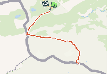
Randonnée Marche de 11,7 km à découvrir à Occitanie, Hautes-Pyrénées, Gavarnie-Gèdre. Cette randonnée est proposée par hugha.
Description
Départ du parking au col de Tentes 2200m pour la brêche de Roland 2800m.Moyenne montagne,tenue rando sérieuse OBLIGATOIRE
Localisation
Pays :
France
Région :
Occitanie
Département/Province :
Hautes-Pyrénées
Commune :
Gavarnie-Gèdre
Localité :
Gavarnie
Départ:(Dec)
Départ:(UTM)
741501 ; 4733224 (30T) N.
Commentaires
Randonnées à proximité
![Randonnée Marche Torla-Ordesa - Soum Blanc des Espécières-Col des Tentes - Photo](https://media.geolcdn.com/t/375/260/ext.jpg?maxdim=2&url=https%3A%2F%2Fservices.sitytrail.com%2FGeolivesWS%2FDownloadMedia.ashx%3FTrailID%3D218642%26Media%3Dfix__20130902152651.jpg)
![Marche Marche](https://static1.geolcdn.com/sitytour/trail-icons/101.png)
Soum Blanc des Espécières-Col des Tentes
Marche
Difficile
(7)
Torla-Ordesa,
Aragon,
Huesca,
Espagne
![](/images/other/stat-length.png)
4 km | 5,7 km-effort
1h 42min
![](https://static1.geolcdn.com/siteimages/upload/files/16400158638029165_repeat_loop_refresh_sync_direction_icon.png)
Non
![Randonnée Marche Gavarnie-Gèdre - Lac de la Bernatoire - Photo](https://media.geolcdn.com/t/375/260/ext.jpg?maxdim=2&url=https%3A%2F%2Fstatic1.geolcdn.com%2Fsiteimages%2Fupload%2Ffiles%2F1553511878bg_sport_marche.png)
![Marche Marche](https://static1.geolcdn.com/sitytour/trail-icons/101.png)
Lac de la Bernatoire
Marche
Moyen
(8)
Gavarnie-Gèdre,
Occitanie,
Hautes-Pyrénées,
France
![](/images/other/stat-length.png)
12,7 km | 22 km-effort
4h 36min
![](https://static1.geolcdn.com/siteimages/upload/files/16400158638029165_repeat_loop_refresh_sync_direction_icon.png)
Oui
![Randonnée Marche Gavarnie-Gèdre - Breche de Rolland - Photo](https://media.geolcdn.com/t/375/260/ext.jpg?maxdim=2&url=https%3A%2F%2Fservices.sitytrail.com%2FGeolivesWS%2FDownloadMedia.ashx%3FTrailID%3D334692%26Media%3Dfix__20140811120248.jpg)
![Marche Marche](https://static1.geolcdn.com/sitytour/trail-icons/101.png)
Breche de Rolland
Marche
Facile
(3)
Gavarnie-Gèdre,
Occitanie,
Hautes-Pyrénées,
France
![](/images/other/stat-length.png)
12,1 km | 22 km-effort
4h 34min
![](https://static1.geolcdn.com/siteimages/upload/files/16400158638029165_repeat_loop_refresh_sync_direction_icon.png)
Oui
![Randonnée Marche Gavarnie-Gèdre - Le Cirque de Gavarnie autrement - Photo](https://media.geolcdn.com/t/375/260/ext.jpg?maxdim=2&url=https%3A%2F%2Fservices.sitytrail.com%2FGeolivesWS%2FDownloadMedia.ashx%3FTrailID%3D103374%26Media%3D5436_6.jpg)
![Marche Marche](https://static1.geolcdn.com/sitytour/trail-icons/101.png)
Le Cirque de Gavarnie autrement
Marche
Moyen
(2)
Gavarnie-Gèdre,
Occitanie,
Hautes-Pyrénées,
France
![](/images/other/stat-length.png)
9,1 km | 15,6 km-effort
3h 0min
![](https://static1.geolcdn.com/siteimages/upload/files/16400158638029165_repeat_loop_refresh_sync_direction_icon.png)
Oui
![Randonnée Marche Gavarnie-Gèdre - Faja de las Flores - Photo](https://media.geolcdn.com/t/375/260/ext.jpg?maxdim=2&url=https%3A%2F%2Fservices.sitytrail.com%2FGeolivesWS%2FDownloadMedia.ashx%3FTrailID%3D102724%26Media%3D3837_6.jpg)
![Marche Marche](https://static1.geolcdn.com/sitytour/trail-icons/101.png)
Faja de las Flores
Marche
Très difficile
(1)
Gavarnie-Gèdre,
Occitanie,
Hautes-Pyrénées,
France
![](/images/other/stat-length.png)
22 km | 45 km-effort
13h 0min
![](https://static1.geolcdn.com/siteimages/upload/files/16400158638029165_repeat_loop_refresh_sync_direction_icon.png)
Oui
![Randonnée Marche Gavarnie-Gèdre - Le Soum Blanc des Especières 2685m depuis le col de Tentes - Photo](https://media.geolcdn.com/t/375/260/ext.jpg?maxdim=2&url=https%3A%2F%2Fservices.sitytrail.com%2FGeolivesWS%2FDownloadMedia.ashx%3FTrailID%3D109867%26Media%3D4854_1.jpg)
![Marche Marche](https://static1.geolcdn.com/sitytour/trail-icons/101.png)
Le Soum Blanc des Especières 2685m depuis le col de Tentes
Marche
Difficile
(2)
Gavarnie-Gèdre,
Occitanie,
Hautes-Pyrénées,
France
![](/images/other/stat-length.png)
5,6 km | 12,6 km-effort
3h 0min
![](https://static1.geolcdn.com/siteimages/upload/files/16400158638029165_repeat_loop_refresh_sync_direction_icon.png)
Oui
![Randonnée Marche Gavarnie-Gèdre - Le Casque du Marboré 3006m depuis le col de Tentes (2208m) - Photo](https://media.geolcdn.com/t/375/260/ext.jpg?maxdim=2&url=https%3A%2F%2Fservices.sitytrail.com%2FGeolivesWS%2FDownloadMedia.ashx%3FTrailID%3D109814%26Media%3D4776_1.jpg)
![Marche Marche](https://static1.geolcdn.com/sitytour/trail-icons/101.png)
Le Casque du Marboré 3006m depuis le col de Tentes (2208m)
Marche
Très difficile
(1)
Gavarnie-Gèdre,
Occitanie,
Hautes-Pyrénées,
France
![](/images/other/stat-length.png)
7 km | 16,4 km-effort
7h 0min
![](https://static1.geolcdn.com/siteimages/upload/files/16400158638029165_repeat_loop_refresh_sync_direction_icon.png)
Non
![Randonnée Randonnée équestre Gavarnie-Gèdre - Cirque de Gavarnie et variante - Photo](https://media.geolcdn.com/t/375/260/85d1392a-7f00-4f3f-8519-147898e5e510.jpg&format=jpg&maxdim=2)
![Randonnée équestre Randonnée équestre](https://static1.geolcdn.com/sitytour/trail-icons/301.png)
Cirque de Gavarnie et variante
Randonnée équestre
Facile
Gavarnie-Gèdre,
Occitanie,
Hautes-Pyrénées,
France
![](/images/other/stat-length.png)
29 km | 37 km-effort
3h 12min
![](https://static1.geolcdn.com/siteimages/upload/files/16400158638029165_repeat_loop_refresh_sync_direction_icon.png)
Non
![Randonnée Marche Gavarnie-Gèdre - GAVARNIE avec Pierre D, Christine et Michel Blavit 3740150 - Photo](https://media.geolcdn.com/t/375/260/dd58b21f-efc7-4d10-b038-8a72ccb92536.jpg&format=jpg&maxdim=2)
![Marche Marche](https://static1.geolcdn.com/sitytour/trail-icons/101.png)
GAVARNIE avec Pierre D, Christine et Michel Blavit 3740150
Marche
Difficile
Gavarnie-Gèdre,
Occitanie,
Hautes-Pyrénées,
France
![](/images/other/stat-length.png)
10,5 km | 17,2 km-effort
3h 53min
![](https://static1.geolcdn.com/siteimages/upload/files/16400158638029165_repeat_loop_refresh_sync_direction_icon.png)
Oui