![](/images/other/stat-length.png)
![Randonnée V.T.T. Terre-de-Bancalié - La Pimentoise - Lac de la Bancalié - Photo](https://media.geolcdn.com/t/1900/400/ext.pjpeg?maxdim=2&url=https%3A%2F%2Fstatic1.geolcdn.com%2Fsiteimages%2Fupload%2Ffiles%2F1524743154velo.jpg)
La Pimentoise - Lac de la Bancalié
tracegps
Utilisateur
![Longueur](/images/other/stat-length.png)
Longueur
58 km
![Altitude max](https://static1.geolcdn.com/siteimages/upload/files/1508320355ic_sort_altitude_max_24dp.png)
Altitude max
587 m
![Dénivelé positif](https://static1.geolcdn.com/siteimages/upload/files/1508320355ic_sort_den_pos_24dp.png)
Dénivelé positif
1767 m
![Km-Effort](/images/other/stat-length.png)
Km-Effort
81 km
![Altitude min](https://static1.geolcdn.com/siteimages/upload/files/1508320355ic_sort_altitude_min_24dp.png)
Altitude min
254 m
![Dénivelé négatif](https://static1.geolcdn.com/siteimages/upload/files/1508320355ic_sort_den_neg_24dp.png)
Dénivelé négatif
1745 m
![Boucle](https://static1.geolcdn.com/siteimages/upload/files/16400158638029165_repeat_loop_refresh_sync_direction_icon.png)
Boucle
Non
Date de création :
2014-12-10 00:00:00.0
Dernière modification :
2014-12-10 00:00:00.0
![V.T.T.](https://static1.geolcdn.com/sitytour/trail-icons/202.png)
4h30
Difficulté : Très difficile
![Scannez ce code QR pour ouvrir la randonnée dans l'application SityTrail](https://capi.geolives.com/qq0zvz2zws4bq2lad0pu/sitytour/trails/100927/qr.png?size=200)
Application GPS de randonnée GRATUITE
À propos
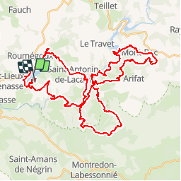
Randonnée V.T.T. de 58 km à découvrir à Occitanie, Tarn, Terre-de-Bancalié. Cette randonnée est proposée par tracegps.
Description
3 Sept 2006 Une rando méconnue mais bien organisée. Une succession de montées descentes qui usent, surtout avec la chaleur en fin de parcours. 60kms pour 1750m D quand même ! La suite est ICI Source Rowel
Localisation
Pays :
France
Région :
Occitanie
Département/Province :
Tarn
Commune :
Terre-de-Bancalié
Localité :
Saint-Antonin-de-Lacalm
Départ:(Dec)
Départ:(UTM)
441023 ; 4847926 (31T) N.
Commentaires
Randonnées à proximité
![Randonnée Marche Terre-de-Bancalié - 81_Saint Lieux Lafenasse - Photo](https://media.geolcdn.com/t/375/260/ext.jpg?maxdim=2&url=https%3A%2F%2Fstatic1.geolcdn.com%2Fsiteimages%2Fupload%2Ffiles%2F1553511878bg_sport_marche.png)
![Marche Marche](https://static1.geolcdn.com/sitytour/trail-icons/101.png)
81_Saint Lieux Lafenasse
Marche
Moyen
(1)
Terre-de-Bancalié,
Occitanie,
Tarn,
France
![](/images/other/stat-length.png)
18,1 km | 23 km-effort
4h 27min
![](https://static1.geolcdn.com/siteimages/upload/files/16400158638029165_repeat_loop_refresh_sync_direction_icon.png)
Oui
![Randonnée Marche Terre-de-Bancalié - Tour du lac de la bancalié - Photo](https://media.geolcdn.com/t/375/260/65fd62b2-fe1b-4eaa-bb5a-c1013eaa486f.jpg&format=jpg&maxdim=2)
![Marche Marche](https://static1.geolcdn.com/sitytour/trail-icons/101.png)
Tour du lac de la bancalié
Marche
Facile
Terre-de-Bancalié,
Occitanie,
Tarn,
France
![](/images/other/stat-length.png)
10,2 km | 12,4 km-effort
3h 3min
![](https://static1.geolcdn.com/siteimages/upload/files/16400158638029165_repeat_loop_refresh_sync_direction_icon.png)
Oui
![Randonnée Marche Terre-de-Bancalié - Chemin des Mineurs - Photo](https://media.geolcdn.com/t/375/260/ext.jpg?maxdim=2&url=https%3A%2F%2Fstatic1.geolcdn.com%2Fsiteimages%2Fupload%2Ffiles%2F1553511878bg_sport_marche.png)
![Marche Marche](https://static1.geolcdn.com/sitytour/trail-icons/101.png)
Chemin des Mineurs
Marche
Difficile
Terre-de-Bancalié,
Occitanie,
Tarn,
France
![](/images/other/stat-length.png)
10,4 km | 14 km-effort
3h 11min
![](https://static1.geolcdn.com/siteimages/upload/files/16400158638029165_repeat_loop_refresh_sync_direction_icon.png)
Oui
![Randonnée Vélo électrique Terre-de-Bancalié - Boucle de Roque à Roque - Photo](https://media.geolcdn.com/t/375/260/ext.jpg?maxdim=2&url=https%3A%2F%2Fstatic1.geolcdn.com%2Fsiteimages%2Fupload%2Ffiles%2F1524743154velo.jpg)
![Vélo électrique Vélo électrique](https://static1.geolcdn.com/sitytour/trail-icons/205.png)
Boucle de Roque à Roque
Vélo électrique
Difficile
(1)
Terre-de-Bancalié,
Occitanie,
Tarn,
France
![](/images/other/stat-length.png)
29 km | 41 km-effort
Inconnu
![](https://static1.geolcdn.com/siteimages/upload/files/16400158638029165_repeat_loop_refresh_sync_direction_icon.png)
Oui
![Randonnée Marche Terre-de-Bancalié - prepa fev - Photo](https://media.geolcdn.com/t/375/260/ext.jpg?maxdim=2&url=https%3A%2F%2Fstatic1.geolcdn.com%2Fsiteimages%2Fupload%2Ffiles%2F1553511878bg_sport_marche.png)
![Marche Marche](https://static1.geolcdn.com/sitytour/trail-icons/101.png)
prepa fev
Marche
Facile
Terre-de-Bancalié,
Occitanie,
Tarn,
France
![](/images/other/stat-length.png)
6,4 km | 8,5 km-effort
1h 55min
![](https://static1.geolcdn.com/siteimages/upload/files/16400158638029165_repeat_loop_refresh_sync_direction_icon.png)
Oui
![Randonnée Moteur Terre-de-Bancalié - rando 4X4 - Photo](https://media.geolcdn.com/t/375/260/ext.jpg?maxdim=2&url=https%3A%2F%2Fstatic1.geolcdn.com%2Fsiteimages%2Fupload%2Ffiles%2F15247431544x4.jpg)
![Moteur Moteur](https://static1.geolcdn.com/sitytour/trail-icons/400.png)
rando 4X4
Moteur
Moyen
Terre-de-Bancalié,
Occitanie,
Tarn,
France
![](/images/other/stat-length.png)
85 km | 118 km-effort
3h 25min
![](https://static1.geolcdn.com/siteimages/upload/files/16400158638029165_repeat_loop_refresh_sync_direction_icon.png)
Non
![Randonnée Marche Arifat - Cascades de Arifat - Photo](https://media.geolcdn.com/t/375/260/ext.jpg?maxdim=2&url=https%3A%2F%2Fstatic1.geolcdn.com%2Fsiteimages%2Fupload%2Ffiles%2F1553511878bg_sport_marche.png)
![Marche Marche](https://static1.geolcdn.com/sitytour/trail-icons/101.png)
Cascades de Arifat
Marche
Moyen
Arifat,
Occitanie,
Tarn,
France
![](/images/other/stat-length.png)
8,7 km | 13,1 km-effort
2h 39min
![](https://static1.geolcdn.com/siteimages/upload/files/16400158638029165_repeat_loop_refresh_sync_direction_icon.png)
Oui
![Randonnée sport Terre-de-Bancalié - Chemin des mineurs de lafenasse - Photo](https://media.geolcdn.com/t/375/260/ext.jpg?maxdim=2&url=https%3A%2F%2Fsecurestorage.geolives.com%2Fsitytour%2Ftrail-bg%2Fdefault.jpg)
Chemin des mineurs de lafenasse
sport
Très facile
Terre-de-Bancalié,
Occitanie,
Tarn,
France
![](/images/other/stat-length.png)
10,9 km | 14,6 km-effort
Inconnu
![](https://static1.geolcdn.com/siteimages/upload/files/16400158638029165_repeat_loop_refresh_sync_direction_icon.png)
Oui
![Randonnée Marche Terre-de-Bancalié - bancalié - Photo](https://media.geolcdn.com/t/375/260/ext.jpg?maxdim=2&url=https%3A%2F%2Fstatic1.geolcdn.com%2Fsiteimages%2Fupload%2Ffiles%2F1553511878bg_sport_marche.png)
![Marche Marche](https://static1.geolcdn.com/sitytour/trail-icons/101.png)
bancalié
Marche
Difficile
Terre-de-Bancalié,
Occitanie,
Tarn,
France
![](/images/other/stat-length.png)
11,1 km | 13,7 km-effort
1h 54min
![](https://static1.geolcdn.com/siteimages/upload/files/16400158638029165_repeat_loop_refresh_sync_direction_icon.png)
Oui