Randonnée Marche La Chapelle-Neuve - circuit des 3 chapelles - Photo

circuit des 3 chapelles

 jojo96
jojo96

Utilisateur

© OpenStreetMap contributors
Longueur
Longueur
18,6 km
Altitude max
Altitude max
132 m
Dénivelé positif
Dénivelé positif
295 m
Km-Effort
Km-Effort  
23 km
Altitude min
Altitude min
36 m
Dénivelé négatif
Dénivelé négatif
285 m
Boucle
Boucle
Oui
Date de création :
2019-01-15 13:20:35.177
Dernière modification :
2019-01-15 13:20:35.177

(0 Avis)

Marche
Marche
4h05
Difficulté : Facile

Scannez ce code QR pour ouvrir la randonnée dans l'application SityTrail

Application GPS de randonnée GRATUITE

Logo SityTrail SityTrail

IGN / Instituts géographiques

Télécharger SityTrail sur l'App Store Télécharger SityTrail sur Google Play

Logo SityTrail SityTrail World

Le monde est à vous

Télécharger SityTrail sur l'App Store Télécharger SityTrail sur Google Play Télécharger SityTrail sur Huawei AppGallery

À propos

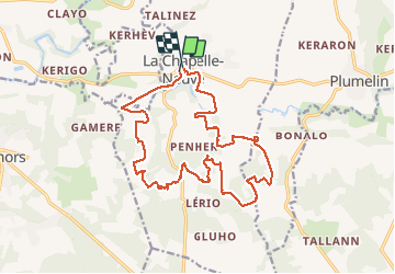
Randonnée Marche de 18,6 km à découvrir à Bretagne, Morbihan, La Chapelle-Neuve. Cette randonnée est proposée par jojo96.

Description

depart la chapelle neuve

Profil altimétrique

Localisation

Pays :
France
Région :
Bretagne
Département/Province :
Morbihan
Commune :
La Chapelle-Neuve
Localité :
Unknown
Départ:(Dec)
Départ:(UTM)
504245 ; 5301185 (30T) N.

Randonnées à proximité

Randonnée Marche La Chapelle-Neuve - PR_56_La-Chapelle-Neuve_AA_01_Circuit3b_De-Floranges_20240307 - Photo
Marche
patrickdanilo

Marche

Difficile
La Chapelle-Neuve, Bretagne, Morbihan, France
10,9 km | 13,1 km-effort
2h 58min
Oui
Randonnée V.T.T. La Chapelle-Neuve - Espace VTT FFC La vallée du Blavet - Le circuit des 3 chapelles - Photo
V.T.T.
tracegps

V.T.T.

Moyen
La Chapelle-Neuve, Bretagne, Morbihan, France
16,7 km | 20 km-effort
2h 0min
Oui
Randonnée Marche La Chapelle-Neuve - Espace VTT FFC La vallée du Blavet - Le circuit des 3 chapelles - Photo
Marche
tracegps

Marche

Difficile
La Chapelle-Neuve, Bretagne, Morbihan, France
16,7 km | 20 km-effort
5h 0min
Oui
Randonnée Cheval La Chapelle-Neuve - Espace VTT FFC La vallée du Blavet - Le circuit de Floranges - Photo
Cheval
tracegps

Cheval

Moyen
La Chapelle-Neuve, Bretagne, Morbihan, France
10,9 km | 13,1 km-effort
1h 19min
Oui
Randonnée V.T.T. La Chapelle-Neuve - Espace VTT FFC La vallée du Blavet - Le circuit de Floranges - Photo
V.T.T.
tracegps

V.T.T.

Moyen
La Chapelle-Neuve, Bretagne, Morbihan, France
10,9 km | 13,1 km-effort
1h 0min
Oui
Randonnée Marche La Chapelle-Neuve - Espace VTT FFC La vallée du Blavet - Le circuit de Floranges - Photo
Marche
tracegps

Marche

Moyen
La Chapelle-Neuve, Bretagne, Morbihan, France
10,9 km | 13,1 km-effort
3h 0min
Oui
Randonnée Marche Guénin - Guenin Tenuel - Photo
Marche
Biau-Patrick

Marche

Facile
Guénin, Bretagne, Morbihan, France
10,3 km | 13,4 km-effort
2h 11min
Oui
Randonnée Marche Camors - CAMORS -alignements de Cornevec - Photo
Marche
shadow

Marche

Facile
Camors, Bretagne, Morbihan, France
9,9 km | 11,9 km-effort
2h 34min
Oui
Randonnée V.T.T. Baud - Baud 2023 - Photo
V.T.T.
nicoleroy

V.T.T.

Facile
Baud, Bretagne, Morbihan, France
9,5 km | 11,8 km-effort
39min
Non


Fermer
Mes abonnements