![](/images/other/stat-length.png)
![Randonnée V.T.T. Barbâtre - Ile de Noirmoutier - Photo](https://media.geolcdn.com/t/1900/400/ext.pjpeg?maxdim=2&url=https%3A%2F%2Fservices.sitytrail.com%2FGeolivesWS%2FDownloadMedia.ashx%3FTrailID%3D100765%26Media%3D275_6.jpg)
Ile de Noirmoutier
tracegps
Utilisateur
![Longueur](/images/other/stat-length.png)
![Altitude max](https://static1.geolcdn.com/siteimages/upload/files/1508320355ic_sort_altitude_max_24dp.png)
![Dénivelé positif](https://static1.geolcdn.com/siteimages/upload/files/1508320355ic_sort_den_pos_24dp.png)
![Km-Effort](/images/other/stat-length.png)
![Altitude min](https://static1.geolcdn.com/siteimages/upload/files/1508320355ic_sort_altitude_min_24dp.png)
![Dénivelé négatif](https://static1.geolcdn.com/siteimages/upload/files/1508320355ic_sort_den_neg_24dp.png)
![Boucle](https://static1.geolcdn.com/siteimages/upload/files/16400158638029165_repeat_loop_refresh_sync_direction_icon.png)
![V.T.T.](https://static1.geolcdn.com/sitytour/trail-icons/202.png)
2h00
Difficulté : Moyen
![Scannez ce code QR pour ouvrir la randonnée dans l'application SityTrail](https://capi.geolives.com/qq0zvz2zws4bq2lad0pu/sitytour/trails/100765/qr.png?size=200)
Application GPS de randonnée GRATUITE
À propos
Randonnée V.T.T. de 31 km à découvrir à Pays de la Loire, Vendée, Barbâtre. Cette randonnée est proposée par tracegps.
Description
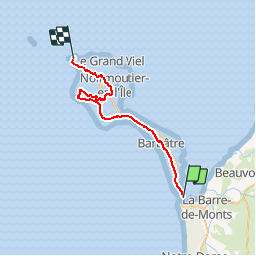
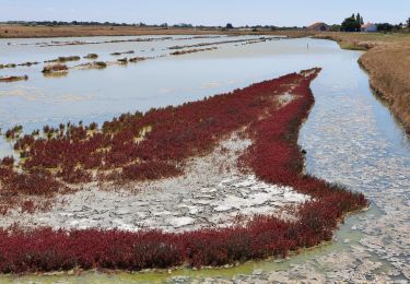
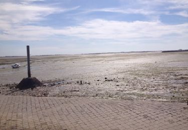
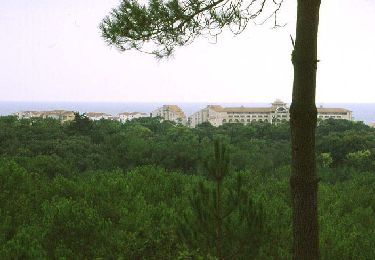
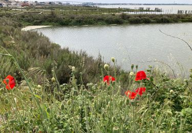
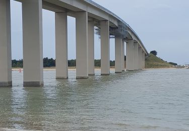
Traversant toute l'île de Noirmoutier, de la Pointe de l'Herbaudière au nord à la Pointe de la Fosse au sud (Pont de Noirmoutier), ce circuit longe les marais salants et permet de découvrir les villages traditionnels et paysages naturels et agricoles de l'île. Des boucles situées dans chaque commune permettent de compléter la promenade, notamment le long de la digue bordant la baie de Bourgneuf, en direction du Gois.(source http://pistes-cyclables.vendee.fr/pistes/piste02.asp)
Localisation
Commentaires
Randonnées à proximité
![Randonnée A pied Barbâtre - Les portes de l'île - Photo](https://media.geolcdn.com/t/375/260/82a1d405-bb0f-46bc-9ffd-a50bc0af4a29.jpeg&format=jpg&maxdim=2)
![A pied A pied](https://static1.geolcdn.com/sitytour/trail-icons/100.png)
A pied
![](/images/other/stat-length.png)
![](https://static1.geolcdn.com/siteimages/upload/files/16400158638029165_repeat_loop_refresh_sync_direction_icon.png)
![Randonnée Marche Barbâtre - jeun rando J1 Baratre - Photo](https://media.geolcdn.com/t/375/260/052b7d91-e778-4040-825e-3d224ceba272.jpg&format=jpg&maxdim=2)
![Marche Marche](https://static1.geolcdn.com/sitytour/trail-icons/101.png)
Marche
![](/images/other/stat-length.png)
![](https://static1.geolcdn.com/siteimages/upload/files/16400158638029165_repeat_loop_refresh_sync_direction_icon.png)
![Randonnée V.T.C. La Barre-de-Monts - La Barre-de-Monts-Boucle du Daviaud - Photo](https://media.geolcdn.com/t/375/260/f7185e7c-5ab5-482f-bfdb-40b3b1459f78.jpg&format=jpg&maxdim=2)
![V.T.C. V.T.C.](https://static1.geolcdn.com/sitytour/trail-icons/203.png)
V.T.C.
![](/images/other/stat-length.png)
![](https://static1.geolcdn.com/siteimages/upload/files/16400158638029165_repeat_loop_refresh_sync_direction_icon.png)
![Randonnée Marche La Barre-de-Monts - ostréiculteurs - Photo](https://media.geolcdn.com/t/375/260/072a44b0-c952-4e8b-9f56-93c4ce319af4.jpg&format=jpg&maxdim=2)
![Marche Marche](https://static1.geolcdn.com/sitytour/trail-icons/101.png)
Marche
![](/images/other/stat-length.png)
![](https://static1.geolcdn.com/siteimages/upload/files/16400158638029165_repeat_loop_refresh_sync_direction_icon.png)
![Randonnée Marche Barbâtre - le pont, moulin des yuccas, le gois, le pont de Noirmoutier - Photo](https://media.geolcdn.com/t/375/260/ext.jpg?maxdim=2&url=https%3A%2F%2Fservices.sitytrail.com%2FGeolivesWS%2FDownloadMedia.ashx%3FTrailID%3D153890%26Media%3D20120916132328.jpg)
![Marche Marche](https://static1.geolcdn.com/sitytour/trail-icons/101.png)
Marche
![](/images/other/stat-length.png)
![](https://static1.geolcdn.com/siteimages/upload/files/16400158638029165_repeat_loop_refresh_sync_direction_icon.png)
![Randonnée Roller Barbâtre - Ile de Noirmoutier - Photo](https://media.geolcdn.com/t/375/260/ext.jpg?maxdim=2&url=https%3A%2F%2Fservices.sitytrail.com%2FGeolivesWS%2FDownloadMedia.ashx%3FTrailID%3D100766%26Media%3D275_3.jpg)
![Roller Roller](https://static1.geolcdn.com/sitytour/trail-icons/901.png)
Roller
![](/images/other/stat-length.png)
![](https://static1.geolcdn.com/siteimages/upload/files/16400158638029165_repeat_loop_refresh_sync_direction_icon.png)
![Randonnée Marche La Barre-de-Monts - Fromentine - Photo](https://media.geolcdn.com/t/375/260/8e53e7f5-6db2-45d9-8c0c-82e686135ce0.jpg&format=jpg&maxdim=2)
![Marche Marche](https://static1.geolcdn.com/sitytour/trail-icons/101.png)
Marche
![](/images/other/stat-length.png)
![](https://static1.geolcdn.com/siteimages/upload/files/16400158638029165_repeat_loop_refresh_sync_direction_icon.png)
![Randonnée Marche La Barre-de-Monts - Le phare - Photo](https://media.geolcdn.com/t/375/260/7a62d1a4-1739-4153-ae0a-3f1795228efe.jpg&format=jpg&maxdim=2)
![Marche Marche](https://static1.geolcdn.com/sitytour/trail-icons/101.png)
Marche
![](/images/other/stat-length.png)
![](https://static1.geolcdn.com/siteimages/upload/files/16400158638029165_repeat_loop_refresh_sync_direction_icon.png)
![Randonnée Marche La Barre-de-Monts - Littoral - Photo](https://media.geolcdn.com/t/375/260/0c29451a-3d9d-42d6-becb-e687c92d1114.jpg&format=jpg&maxdim=2)
![Marche Marche](https://static1.geolcdn.com/sitytour/trail-icons/101.png)
Marche
![](/images/other/stat-length.png)
![](https://static1.geolcdn.com/siteimages/upload/files/16400158638029165_repeat_loop_refresh_sync_direction_icon.png)