![](/images/other/stat-length.png)
![Randonnée V.T.T. Saint-Laurent-Médoc - 8ème rallye en forêt et vignes du haut Médoc - Photo](https://media.geolcdn.com/t/1900/400/ext.pjpeg?maxdim=2&url=https%3A%2F%2Fstatic1.geolcdn.com%2Fsiteimages%2Fupload%2Ffiles%2F1524743154velo.jpg)
8ème rallye en forêt et vignes du haut Médoc
tracegps
Utilisateur
![Longueur](/images/other/stat-length.png)
Longueur
50 km
![Altitude max](https://static1.geolcdn.com/siteimages/upload/files/1508320355ic_sort_altitude_max_24dp.png)
Altitude max
42 m
![Dénivelé positif](https://static1.geolcdn.com/siteimages/upload/files/1508320355ic_sort_den_pos_24dp.png)
Dénivelé positif
283 m
![Km-Effort](/images/other/stat-length.png)
Km-Effort
54 km
![Altitude min](https://static1.geolcdn.com/siteimages/upload/files/1508320355ic_sort_altitude_min_24dp.png)
Altitude min
0 m
![Dénivelé négatif](https://static1.geolcdn.com/siteimages/upload/files/1508320355ic_sort_den_neg_24dp.png)
Dénivelé négatif
282 m
![Boucle](https://static1.geolcdn.com/siteimages/upload/files/16400158638029165_repeat_loop_refresh_sync_direction_icon.png)
Boucle
Non
Date de création :
2014-12-10 00:00:00.0
Dernière modification :
2014-12-10 00:00:00.0
![V.T.T.](https://static1.geolcdn.com/sitytour/trail-icons/202.png)
3h00
Difficulté : Moyen
![Scannez ce code QR pour ouvrir la randonnée dans l'application SityTrail](https://capi.geolives.com/qq0zvz2zws4bq2lad0pu/sitytour/trails/100706/qr.png?size=200)
Application GPS de randonnée GRATUITE
À propos
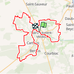
Randonnée V.T.T. de 50 km à découvrir à Nouvelle-Aquitaine, Gironde, Saint-Laurent-Médoc. Cette randonnée est proposée par tracegps.
Description
Rando FFCT organisée par le club FFCT la Cocarde. Le parcours reste la plupart du temps sur de larges pistes roulantes, à l'exception d'un sentier en forêt bien dégagé pour l'occasion. Circuit agréable en été.
Localisation
Pays :
France
Région :
Nouvelle-Aquitaine
Département/Province :
Gironde
Commune :
Saint-Laurent-Médoc
Localité :
Unknown
Départ:(Dec)
Départ:(UTM)
670850 ; 5002688 (30T) N.
Commentaires
Randonnées à proximité
![Randonnée Marche Saint-Laurent-Médoc - autour de Pauillac - Photo](https://media.geolcdn.com/t/375/260/0223e1f2-07bc-4df6-87df-6c2d04107bd0.jpg&format=jpg&maxdim=2)
![Marche Marche](https://static1.geolcdn.com/sitytour/trail-icons/101.png)
autour de Pauillac
Marche
Facile
Saint-Laurent-Médoc,
Nouvelle-Aquitaine,
Gironde,
France
![](/images/other/stat-length.png)
20 km | 22 km-effort
4h 44min
![](https://static1.geolcdn.com/siteimages/upload/files/16400158638029165_repeat_loop_refresh_sync_direction_icon.png)
Oui
![Randonnée Marche Saint-Laurent-Médoc - St.Laurent.Médoc+Bernos+Benon - Photo](https://media.geolcdn.com/t/375/260/ext.jpg?maxdim=2&url=https%3A%2F%2Fstatic1.geolcdn.com%2Fsiteimages%2Fupload%2Ffiles%2F1553511878bg_sport_marche.png)
![Marche Marche](https://static1.geolcdn.com/sitytour/trail-icons/101.png)
St.Laurent.Médoc+Bernos+Benon
Marche
Moyen
Saint-Laurent-Médoc,
Nouvelle-Aquitaine,
Gironde,
France
![](/images/other/stat-length.png)
11,3 km | 12,4 km-effort
3h 8min
![](https://static1.geolcdn.com/siteimages/upload/files/16400158638029165_repeat_loop_refresh_sync_direction_icon.png)
Non
![Randonnée V.T.T. Saint-Laurent-Médoc - Saussac-VTT-thibault-2jan2020 - Photo](https://media.geolcdn.com/t/375/260/ext.jpg?maxdim=2&url=https%3A%2F%2Fstatic1.geolcdn.com%2Fsiteimages%2Fupload%2Ffiles%2F1524743154velo.jpg)
![V.T.T. V.T.T.](https://static1.geolcdn.com/sitytour/trail-icons/202.png)
Saussac-VTT-thibault-2jan2020
V.T.T.
Très facile
Saint-Laurent-Médoc,
Nouvelle-Aquitaine,
Gironde,
France
![](/images/other/stat-length.png)
11,5 km | 12,4 km-effort
54min
![](https://static1.geolcdn.com/siteimages/upload/files/16400158638029165_repeat_loop_refresh_sync_direction_icon.png)
Oui
![Randonnée Marche Saint-Laurent-Médoc - Saussac-Mouralet - Photo](https://media.geolcdn.com/t/375/260/ext.jpg?maxdim=2&url=https%3A%2F%2Fstatic1.geolcdn.com%2Fsiteimages%2Fupload%2Ffiles%2F1553511878bg_sport_marche.png)
![Marche Marche](https://static1.geolcdn.com/sitytour/trail-icons/101.png)
Saussac-Mouralet
Marche
Très facile
Saint-Laurent-Médoc,
Nouvelle-Aquitaine,
Gironde,
France
![](/images/other/stat-length.png)
5,2 km | 5,7 km-effort
1h 1min
![](https://static1.geolcdn.com/siteimages/upload/files/16400158638029165_repeat_loop_refresh_sync_direction_icon.png)
Oui
![Randonnée Marche Saint-Laurent-Médoc - St LAurent Hille - Photo](https://media.geolcdn.com/t/375/260/ext.jpg?maxdim=2&url=https%3A%2F%2Fstatic1.geolcdn.com%2Fsiteimages%2Fupload%2Ffiles%2F1553511878bg_sport_marche.png)
![Marche Marche](https://static1.geolcdn.com/sitytour/trail-icons/101.png)
St LAurent Hille
Marche
Très facile
Saint-Laurent-Médoc,
Nouvelle-Aquitaine,
Gironde,
France
![](/images/other/stat-length.png)
8,8 km | 9,6 km-effort
2h 41min
![](https://static1.geolcdn.com/siteimages/upload/files/16400158638029165_repeat_loop_refresh_sync_direction_icon.png)
Non
![Randonnée Aviron Saint-Laurent-Médoc - rando-barque Arnaud 79 - Photo](https://media.geolcdn.com/t/375/260/ext.jpg?maxdim=2&url=https%3A%2F%2Fsecurestorage.geolives.com%2Fsitytour%2Ftrail-bg%2Fdefault.jpg)
![Aviron Aviron](https://static1.geolcdn.com/sitytour/trail-icons/705.png)
rando-barque Arnaud 79
Aviron
Très facile
Saint-Laurent-Médoc,
Nouvelle-Aquitaine,
Gironde,
France
![](/images/other/stat-length.png)
325 km | 352 km-effort
93h 7min
![](https://static1.geolcdn.com/siteimages/upload/files/16400158638029165_repeat_loop_refresh_sync_direction_icon.png)
Non
![Randonnée Marche Saint-Laurent-Médoc - St Laurent du Médoc - Photo](https://media.geolcdn.com/t/375/260/ext.jpg?maxdim=2&url=https%3A%2F%2Fstatic1.geolcdn.com%2Fsiteimages%2Fupload%2Ffiles%2F1553511878bg_sport_marche.png)
![Marche Marche](https://static1.geolcdn.com/sitytour/trail-icons/101.png)
St Laurent du Médoc
Marche
Facile
Saint-Laurent-Médoc,
Nouvelle-Aquitaine,
Gironde,
France
![](/images/other/stat-length.png)
20 km | 22 km-effort
5h 1min
![](https://static1.geolcdn.com/siteimages/upload/files/16400158638029165_repeat_loop_refresh_sync_direction_icon.png)
Oui
![Randonnée Marche Saint-Laurent-Médoc - Rando-Jules: 31déc2021 - Photo](https://media.geolcdn.com/t/375/260/ext.jpg?maxdim=2&url=https%3A%2F%2Fstatic1.geolcdn.com%2Fsiteimages%2Fupload%2Ffiles%2F1553511878bg_sport_marche.png)
![Marche Marche](https://static1.geolcdn.com/sitytour/trail-icons/101.png)
Rando-Jules: 31déc2021
Marche
Facile
Saint-Laurent-Médoc,
Nouvelle-Aquitaine,
Gironde,
France
![](/images/other/stat-length.png)
4,2 km | 4,5 km-effort
1h 6min
![](https://static1.geolcdn.com/siteimages/upload/files/16400158638029165_repeat_loop_refresh_sync_direction_icon.png)
Oui
![Randonnée Marche Saint-Laurent-Médoc - Randi-Bernis0 - Photo](https://media.geolcdn.com/t/375/260/ext.jpg?maxdim=2&url=https%3A%2F%2Fstatic1.geolcdn.com%2Fsiteimages%2Fupload%2Ffiles%2F1553511878bg_sport_marche.png)
![Marche Marche](https://static1.geolcdn.com/sitytour/trail-icons/101.png)
Randi-Bernis0
Marche
Moyen
Saint-Laurent-Médoc,
Nouvelle-Aquitaine,
Gironde,
France
![](/images/other/stat-length.png)
9 km | 9,8 km-effort
2h 10min
![](https://static1.geolcdn.com/siteimages/upload/files/16400158638029165_repeat_loop_refresh_sync_direction_icon.png)
Oui