![](/images/other/stat-length.png)
![Randonnée V.T.T. Neuil - Les tranchelions - Photo](https://media.geolcdn.com/t/1900/400/ext.pjpeg?maxdim=2&url=https%3A%2F%2Fstatic1.geolcdn.com%2Fsiteimages%2Fupload%2Ffiles%2F1524743154velo.jpg)
Les tranchelions
tracegps
Utilisateur
![Longueur](/images/other/stat-length.png)
![Altitude max](https://static1.geolcdn.com/siteimages/upload/files/1508320355ic_sort_altitude_max_24dp.png)
![Dénivelé positif](https://static1.geolcdn.com/siteimages/upload/files/1508320355ic_sort_den_pos_24dp.png)
![Km-Effort](/images/other/stat-length.png)
![Altitude min](https://static1.geolcdn.com/siteimages/upload/files/1508320355ic_sort_altitude_min_24dp.png)
![Dénivelé négatif](https://static1.geolcdn.com/siteimages/upload/files/1508320355ic_sort_den_neg_24dp.png)
![Boucle](https://static1.geolcdn.com/siteimages/upload/files/16400158638029165_repeat_loop_refresh_sync_direction_icon.png)
![V.T.T.](https://static1.geolcdn.com/sitytour/trail-icons/202.png)
2h30
Difficulté : Difficile
![Scannez ce code QR pour ouvrir la randonnée dans l'application SityTrail](https://capi.geolives.com/qq0zvz2zws4bq2lad0pu/sitytour/trails/100702/qr.png?size=200)
Application GPS de randonnée GRATUITE
À propos
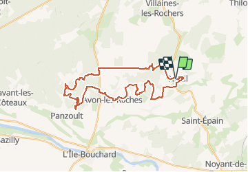
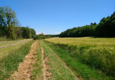
Randonnée V.T.T. de 32 km à découvrir à Centre-Val de Loire, Indre-et-Loire, Neuil. Cette randonnée est proposée par tracegps.
Description
Un circuit qui permet de découvrir les différents points remarquables du secteur.Circuit en boucle passant par les communes de Neuil et Avon les roches. Après être rapidement grimpé sur les hauteurs de Neuil (90 m), vous pourrez observer l'église classé monument historique. Après avoir roulé sur 1 km dans le village avec ses maisons en tuffeau, entrée en forêt de Crissay. Après être sorti de la foret, on enchaîne avec 3 km de ligne droite pour relier la foret de Chinon. Là, il n'y a que du sentier, la plupart en single-track avec un profil plutôt « pentu » pour la région. Retour par Avon les roches, avec ses roches tranchelion. Un petit raidillon qui mene sur une série de caves troglodytes.
Localisation
Commentaires
Randonnées à proximité
![Randonnée V.T.T. Neuil - De Neuil à Avon les Roches - Photo](https://media.geolcdn.com/t/375/260/ext.jpg?maxdim=2&url=https%3A%2F%2Fservices.sitytrail.com%2FGeolivesWS%2FDownloadMedia.ashx%3FTrailID%3D101407%26Media%3D1368_1.jpg)
![V.T.T. V.T.T.](https://static1.geolcdn.com/sitytour/trail-icons/202.png)
V.T.T.
![](/images/other/stat-length.png)
![](https://static1.geolcdn.com/siteimages/upload/files/16400158638029165_repeat_loop_refresh_sync_direction_icon.png)
![Randonnée Marche Crissay-sur-Manse - Crissay-sur-Manse - Neuil Avon-les-Roches - 24.9km 370m 5h20 (30mn) - 2021 07 11 - Photo](https://media.geolcdn.com/t/375/260/683e7d2b-8630-4bdc-a689-c6aa57c47030.jpg&format=jpg&maxdim=2)
![Marche Marche](https://static1.geolcdn.com/sitytour/trail-icons/101.png)
Marche
![](/images/other/stat-length.png)
![](https://static1.geolcdn.com/siteimages/upload/files/16400158638029165_repeat_loop_refresh_sync_direction_icon.png)
![Randonnée Marche Neuil - Neuil - Circuit 2 - 12.6km 120m 2h20 - 2019 08 16 - Photo](https://media.geolcdn.com/t/375/260/124a2bd0-41da-449e-aa3b-94b5534d5b66.jpg&format=jpg&maxdim=2)
![Marche Marche](https://static1.geolcdn.com/sitytour/trail-icons/101.png)
Marche
![](/images/other/stat-length.png)
![](https://static1.geolcdn.com/siteimages/upload/files/16400158638029165_repeat_loop_refresh_sync_direction_icon.png)
![Randonnée Marche Avon-les-Roches - Avon-les-Roches - Au pays des lavoirs - circuit court - 10.9km 130m 2h35 - 2019 06 01 - Photo](https://media.geolcdn.com/t/375/260/6c34328e-f641-4856-bd13-212bbd01020b.jpg&format=jpg&maxdim=2)
![Marche Marche](https://static1.geolcdn.com/sitytour/trail-icons/101.png)
Marche
![](/images/other/stat-length.png)
![](https://static1.geolcdn.com/siteimages/upload/files/16400158638029165_repeat_loop_refresh_sync_direction_icon.png)
![Randonnée Marche Avon-les-Roches - Avon-les-Roches - Lavoirs et Collégiale des Roches Tranchelion - Photo](https://media.geolcdn.com/t/375/260/6d5be714-f66b-4675-8dc9-c78fa6172894.jpg&format=jpg&maxdim=2)
![Marche Marche](https://static1.geolcdn.com/sitytour/trail-icons/101.png)
Marche
![](/images/other/stat-length.png)
![](https://static1.geolcdn.com/siteimages/upload/files/16400158638029165_repeat_loop_refresh_sync_direction_icon.png)
![Randonnée Marche Saint-Épain - Saint-Epain - 14.3km 140m 3h05 - 2020 05 21 - Photo](https://media.geolcdn.com/t/375/260/7fdf136c-7a64-4ac9-8097-e0386c952c86.jpg&format=jpg&maxdim=2)
![Marche Marche](https://static1.geolcdn.com/sitytour/trail-icons/101.png)
Marche
![](/images/other/stat-length.png)
![](https://static1.geolcdn.com/siteimages/upload/files/16400158638029165_repeat_loop_refresh_sync_direction_icon.png)
![Randonnée Marche Crissay-sur-Manse - crissay sur Manse Avon les rochers - Photo](https://media.geolcdn.com/t/375/260/79bf42f8-3c6a-452a-bb3a-7bb46cec95a7.jpg&format=jpg&maxdim=2)
![Marche Marche](https://static1.geolcdn.com/sitytour/trail-icons/101.png)
Marche
![](/images/other/stat-length.png)
![](https://static1.geolcdn.com/siteimages/upload/files/16400158638029165_repeat_loop_refresh_sync_direction_icon.png)
![Randonnée Marche Avon-les-Roches - Avon-les-Roches - Photo](https://media.geolcdn.com/t/375/260/ext.jpg?maxdim=2&url=https%3A%2F%2Fservices.sitytrail.com%2FGeolivesWS%2FDownloadMedia.ashx%3FTrailID%3D111437%26Media%3D7266_3.jpg)
![Marche Marche](https://static1.geolcdn.com/sitytour/trail-icons/101.png)
Marche
![](/images/other/stat-length.png)
![](https://static1.geolcdn.com/siteimages/upload/files/16400158638029165_repeat_loop_refresh_sync_direction_icon.png)
![Randonnée Marche Avon-les-Roches - Avon les roches - Photo](https://media.geolcdn.com/t/375/260/ext.jpg?maxdim=2&url=https%3A%2F%2Fstatic1.geolcdn.com%2Fsiteimages%2Fupload%2Ffiles%2F1553511878bg_sport_marche.png)
![Marche Marche](https://static1.geolcdn.com/sitytour/trail-icons/101.png)
Marche
![](/images/other/stat-length.png)
![](https://static1.geolcdn.com/siteimages/upload/files/16400158638029165_repeat_loop_refresh_sync_direction_icon.png)