![](/images/other/stat-length.png)
![Randonnée V.T.T. Leucate - Leucate sur un plateau ! - Photo](https://media.geolcdn.com/t/1900/400/ext.pjpeg?maxdim=2&url=https%3A%2F%2Fservices.sitytrail.com%2FGeolivesWS%2FDownloadMedia.ashx%3FTrailID%3D100672%26Media%3D196_3.jpg)
Leucate sur un plateau !
tracegps
Utilisateur
![Longueur](/images/other/stat-length.png)
![Altitude max](https://static1.geolcdn.com/siteimages/upload/files/1508320355ic_sort_altitude_max_24dp.png)
![Dénivelé positif](https://static1.geolcdn.com/siteimages/upload/files/1508320355ic_sort_den_pos_24dp.png)
![Km-Effort](/images/other/stat-length.png)
![Altitude min](https://static1.geolcdn.com/siteimages/upload/files/1508320355ic_sort_altitude_min_24dp.png)
![Dénivelé négatif](https://static1.geolcdn.com/siteimages/upload/files/1508320355ic_sort_den_neg_24dp.png)
![Boucle](https://static1.geolcdn.com/siteimages/upload/files/16400158638029165_repeat_loop_refresh_sync_direction_icon.png)
![V.T.T.](https://static1.geolcdn.com/sitytour/trail-icons/202.png)
45m
Difficulté : Facile
![Scannez ce code QR pour ouvrir la randonnée dans l'application SityTrail](https://capi.geolives.com/qq0zvz2zws4bq2lad0pu/sitytour/trails/100672/qr.png?size=200)
Application GPS de randonnée GRATUITE
À propos
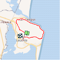
Randonnée V.T.T. de 10,8 km à découvrir à Occitanie, Aude, Leucate. Cette randonnée est proposée par tracegps.
Description
Leucate est une station audoise en bord de Méditerranée. Plusieurs parties la composent, le village, le port, la plage et le plateau. Royaume du vignoble leucatois, entrelacé d’un labyrinthe sans fin de sentiers bordés de murettes de pierres sèches et d’amandiers, le plateau est le paradis des randonneurs. Il se termine par une falaise qui domine les flots de ses 50m de haut. Notre circuit démarre au village et propose un itinéraire qui pourra être modifié facilement. On peut couper par de nombreux sentiers, comme il s’agit d’une presqu’île, on revient toujours vers le village.
Localisation
Commentaires
Randonnées à proximité
![Randonnée Marche Leucate - mon sentier des pêcheurs - Photo](https://media.geolcdn.com/t/375/260/d041d0df-07da-4421-a9ea-d982392d3e0c.jpg&format=jpg&maxdim=2)
![Marche Marche](https://static1.geolcdn.com/sitytour/trail-icons/101.png)
Marche
![](/images/other/stat-length.png)
![](https://static1.geolcdn.com/siteimages/upload/files/16400158638029165_repeat_loop_refresh_sync_direction_icon.png)
![Randonnée Marche Leucate - Leucate village - Photo](https://media.geolcdn.com/t/375/260/ext.jpg?maxdim=2&url=https%3A%2F%2Fservices.sitytrail.com%2FGeolivesWS%2FDownloadMedia.ashx%3FTrailID%3D179085%26Media%3Df1524f36-0682-4bf6-975a-882cd23421f5.JPG)
![Marche Marche](https://static1.geolcdn.com/sitytour/trail-icons/101.png)
![Randonnée V.T.T. Leucate - VTT Leucate La Palme - Photo](https://media.geolcdn.com/t/375/260/f6afc4d0-f8dc-4d8d-bdc2-3236cac7bfec.jpg&format=jpg&maxdim=2)
![V.T.T. V.T.T.](https://static1.geolcdn.com/sitytour/trail-icons/202.png)
V.T.T.
![](/images/other/stat-length.png)
![](https://static1.geolcdn.com/siteimages/upload/files/16400158638029165_repeat_loop_refresh_sync_direction_icon.png)
![Randonnée Marche Leucate - Leucate Sentier du guetteur+ château - Photo](https://media.geolcdn.com/t/375/260/0d9f9422-d3ba-4f9e-b0b9-30df507d067c.jpg&format=jpg&maxdim=2)
![Marche Marche](https://static1.geolcdn.com/sitytour/trail-icons/101.png)
Marche
![](/images/other/stat-length.png)
![](https://static1.geolcdn.com/siteimages/upload/files/16400158638029165_repeat_loop_refresh_sync_direction_icon.png)
![Randonnée Marche Leucate - plateau leucate - sud est - Photo](https://media.geolcdn.com/t/375/260/fc551c80-a7a1-459f-83d9-ef8bc94cafd9.jpg&format=jpg&maxdim=2)
![Marche Marche](https://static1.geolcdn.com/sitytour/trail-icons/101.png)
Marche
![](/images/other/stat-length.png)
![](https://static1.geolcdn.com/siteimages/upload/files/16400158638029165_repeat_loop_refresh_sync_direction_icon.png)
![Randonnée Marche Leucate - leucate - cap des frères (sentier des bergers) -la franqui (sentier des guetteurs) - leucate (se tier des vignerons) - Photo](https://media.geolcdn.com/t/375/260/5389bc4c-6ebc-475a-8eed-23be4124a740.jpg&format=jpg&maxdim=2)
![Marche Marche](https://static1.geolcdn.com/sitytour/trail-icons/101.png)
Marche
![](/images/other/stat-length.png)
![](https://static1.geolcdn.com/siteimages/upload/files/16400158638029165_repeat_loop_refresh_sync_direction_icon.png)
![Randonnée Marche Leucate - Leucate-plateau- A/sentier du vigneronx et R/ sentier du berger - Photo](https://media.geolcdn.com/t/375/260/ext.jpg?maxdim=2&url=https%3A%2F%2Fstatic1.geolcdn.com%2Fsiteimages%2Fupload%2Ffiles%2F1553511878bg_sport_marche.png)
![Marche Marche](https://static1.geolcdn.com/sitytour/trail-icons/101.png)
Marche
![](/images/other/stat-length.png)
![](https://static1.geolcdn.com/siteimages/upload/files/16400158638029165_repeat_loop_refresh_sync_direction_icon.png)
![Randonnée Marche Leucate - Leucate château falaise - Photo](https://media.geolcdn.com/t/375/260/3cce4778-81ed-4254-af5e-b0b5f1ccbabf.jpg&format=jpg&maxdim=2)
![Marche Marche](https://static1.geolcdn.com/sitytour/trail-icons/101.png)
Marche
![](/images/other/stat-length.png)
![](https://static1.geolcdn.com/siteimages/upload/files/16400158638029165_repeat_loop_refresh_sync_direction_icon.png)
![Randonnée Marche Leucate - Plateau etang Leucate - Photo](https://media.geolcdn.com/t/375/260/ext.jpg?maxdim=2&url=https%3A%2F%2Fstatic1.geolcdn.com%2Fsiteimages%2Fupload%2Ffiles%2F1553511878bg_sport_marche.png)
![Marche Marche](https://static1.geolcdn.com/sitytour/trail-icons/101.png)
Marche
![](/images/other/stat-length.png)
![](https://static1.geolcdn.com/siteimages/upload/files/16400158638029165_repeat_loop_refresh_sync_direction_icon.png)
Excellent !