![](/images/other/stat-length.png)
![Randonnée Raquettes à neige Cornimont - La roche des chats - Photo](https://media.geolcdn.com/t/1900/400/ext.pjpeg?maxdim=2&url=https%3A%2F%2Fstatic1.geolcdn.com%2Fsiteimages%2Fupload%2Ffiles%2F1524743153raquette.jpg)
La roche des chats
dboon
Utilisateur
![Longueur](/images/other/stat-length.png)
Longueur
6,9 km
![Altitude max](https://static1.geolcdn.com/siteimages/upload/files/1508320355ic_sort_altitude_max_24dp.png)
Altitude max
1036 m
![Dénivelé positif](https://static1.geolcdn.com/siteimages/upload/files/1508320355ic_sort_den_pos_24dp.png)
Dénivelé positif
147 m
![Km-Effort](/images/other/stat-length.png)
Km-Effort
8,9 km
![Altitude min](https://static1.geolcdn.com/siteimages/upload/files/1508320355ic_sort_altitude_min_24dp.png)
Altitude min
947 m
![Dénivelé négatif](https://static1.geolcdn.com/siteimages/upload/files/1508320355ic_sort_den_neg_24dp.png)
Dénivelé négatif
145 m
![Boucle](https://static1.geolcdn.com/siteimages/upload/files/16400158638029165_repeat_loop_refresh_sync_direction_icon.png)
Boucle
Oui
Date de création :
2014-12-10 00:00:00.0
Dernière modification :
2014-12-10 00:00:00.0
![Raquettes à neige](https://static1.geolcdn.com/sitytour/trail-icons/504.png)
2h08
Difficulté : Facile
![Scannez ce code QR pour ouvrir la randonnée dans l'application SityTrail](https://capi.geolives.com/qq0zvz2zws4bq2lad0pu/sitytour/trails/100417/qr.png?size=200)
Application GPS de randonnée GRATUITE
À propos
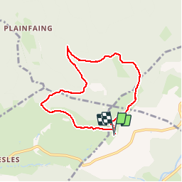
Randonnée Raquettes à neige de 6,9 km à découvrir à Grand Est, Vosges, Cornimont. Cette randonnée est proposée par dboon.
Description
Circulaire en partant du parking de la roche des chats. On longe un peu la tourbière de Jemnaufain, en passant par les charmes, le chalet des charmes, le col de Menufosse pour revenir au point de départ par le Rondfaing
Localisation
Pays :
France
Région :
Grand Est
Département/Province :
Vosges
Commune :
Cornimont
Localité :
Unknown
Départ:(Dec)
Départ:(UTM)
337706 ; 5317746 (32T) N.
Commentaires
Randonnées à proximité
![Randonnée Marche La Bresse - la bresse - le moutier des fées - Photo](https://media.geolcdn.com/t/375/260/8b05ded1-af8a-4cd0-8ffd-c8efb092f1de.jpg&format=jpg&maxdim=2)
![Marche Marche](https://static1.geolcdn.com/sitytour/trail-icons/101.png)
la bresse - le moutier des fées
Marche
Très facile
(1)
La Bresse,
Grand Est,
Vosges,
France
![](/images/other/stat-length.png)
26 km | 36 km-effort
3h 26min
![](https://static1.geolcdn.com/siteimages/upload/files/16400158638029165_repeat_loop_refresh_sync_direction_icon.png)
Non
![Randonnée Marche La Bresse - Le Couchetat - Photo](https://media.geolcdn.com/t/375/260/ext.jpg?maxdim=2&url=https%3A%2F%2Fservices.sitytrail.com%2FGeolivesWS%2FDownloadMedia.ashx%3FTrailID%3D441671%26Media%3D20150706110250.jpg)
![Marche Marche](https://static1.geolcdn.com/sitytour/trail-icons/101.png)
Le Couchetat
Marche
Très facile
(2)
La Bresse,
Grand Est,
Vosges,
France
![](/images/other/stat-length.png)
4,8 km | 7,4 km-effort
1h 50min
![](https://static1.geolcdn.com/siteimages/upload/files/16400158638029165_repeat_loop_refresh_sync_direction_icon.png)
Oui
![Randonnée Marche Cornimont - Xoulces _ Grand Ventron _ Vieille Montagne - Photo](https://media.geolcdn.com/t/375/260/ext.jpg?maxdim=2&url=https%3A%2F%2Fservices.sitytrail.com%2FGeolivesWS%2FDownloadMedia.ashx%3FTrailID%3D439822%26Media%3Dfix__20150630145857.jpg)
![Marche Marche](https://static1.geolcdn.com/sitytour/trail-icons/101.png)
Xoulces _ Grand Ventron _ Vieille Montagne
Marche
Moyen
(1)
Cornimont,
Grand Est,
Vosges,
France
![](/images/other/stat-length.png)
15,6 km | 25 km-effort
5h 6min
![](https://static1.geolcdn.com/siteimages/upload/files/16400158638029165_repeat_loop_refresh_sync_direction_icon.png)
Non
![Randonnée Marche La Bresse - Le col du Brabant et le lac des Corbeaux - Photo](https://media.geolcdn.com/t/375/260/ext.jpg?maxdim=2&url=https%3A%2F%2Fservices.sitytrail.com%2FGeolivesWS%2FDownloadMedia.ashx%3FTrailID%3D418054%26Media%3Dfix__20150508123923.jpg)
![Marche Marche](https://static1.geolcdn.com/sitytour/trail-icons/101.png)
Le col du Brabant et le lac des Corbeaux
Marche
Moyen
(2)
La Bresse,
Grand Est,
Vosges,
France
![](/images/other/stat-length.png)
10,3 km | 16,4 km-effort
3h 51min
![](https://static1.geolcdn.com/siteimages/upload/files/16400158638029165_repeat_loop_refresh_sync_direction_icon.png)
Oui
![Randonnée Marche La Bresse - Le Moutier des Fées_backup_backup - Photo](https://media.geolcdn.com/t/375/260/ext.jpg?maxdim=2&url=https%3A%2F%2Fstatic1.geolcdn.com%2Fsiteimages%2Fupload%2Ffiles%2F1553511878bg_sport_marche.png)
![Marche Marche](https://static1.geolcdn.com/sitytour/trail-icons/101.png)
Le Moutier des Fées_backup_backup
Marche
Facile
(1)
La Bresse,
Grand Est,
Vosges,
France
![](/images/other/stat-length.png)
9,1 km | 15,4 km-effort
3h 11min
![](https://static1.geolcdn.com/siteimages/upload/files/16400158638029165_repeat_loop_refresh_sync_direction_icon.png)
Oui
![Randonnée Randonnée équestre Gerbamont - 2022-06-05 Rando CVA Gerbamont Dommartin les Remiremont - Photo](https://media.geolcdn.com/t/375/260/fd6e9bbc-68c7-4aa5-ac35-74c2c082f858.jpg&format=jpg&maxdim=2)
![Randonnée équestre Randonnée équestre](https://static1.geolcdn.com/sitytour/trail-icons/301.png)
2022-06-05 Rando CVA Gerbamont Dommartin les Remiremont
Randonnée équestre
Difficile
Gerbamont,
Grand Est,
Vosges,
France
![](/images/other/stat-length.png)
24 km | 34 km-effort
5h 10min
![](https://static1.geolcdn.com/siteimages/upload/files/16400158638029165_repeat_loop_refresh_sync_direction_icon.png)
Non
![Randonnée Randonnée équestre Gerbamont - 2022-06-04 Rando CVA Gerbamont Boucle Foret de Noire Goutte - Photo](https://media.geolcdn.com/t/375/260/44bce39b-ceb9-4dae-b553-730e48ff9ece.jpg&format=jpg&maxdim=2)
![Randonnée équestre Randonnée équestre](https://static1.geolcdn.com/sitytour/trail-icons/301.png)
2022-06-04 Rando CVA Gerbamont Boucle Foret de Noire Goutte
Randonnée équestre
Très difficile
Gerbamont,
Grand Est,
Vosges,
France
![](/images/other/stat-length.png)
31 km | 43 km-effort
6h 2min
![](https://static1.geolcdn.com/siteimages/upload/files/16400158638029165_repeat_loop_refresh_sync_direction_icon.png)
Oui
![Randonnée Marche Saulxures-sur-Moselotte - France Vosges saulxure sur Moselotte Etang des fées coteau du bambois 3,6km 22072019 - Photo](https://media.geolcdn.com/t/375/260/ext.jpg?maxdim=2&url=https%3A%2F%2Fstatic1.geolcdn.com%2Fsiteimages%2Fupload%2Ffiles%2F1553511878bg_sport_marche.png)
![Marche Marche](https://static1.geolcdn.com/sitytour/trail-icons/101.png)
France Vosges saulxure sur Moselotte Etang des fées coteau du bambois 3,6km...
Marche
Facile
(2)
Saulxures-sur-Moselotte,
Grand Est,
Vosges,
France
![](/images/other/stat-length.png)
3,6 km | 4,7 km-effort
1h 22min
![](https://static1.geolcdn.com/siteimages/upload/files/16400158638029165_repeat_loop_refresh_sync_direction_icon.png)
Oui
![V.T.T. V.T.T.](https://static1.geolcdn.com/sitytour/trail-icons/202.png)
La Bresse : CIRCUIT VTT N°1 - LES BALCONS DE LA BRESSE
V.T.T.
Facile
La Bresse,
Grand Est,
Vosges,
France
![](/images/other/stat-length.png)
12,5 km | 16,7 km-effort
1h 0min
![](https://static1.geolcdn.com/siteimages/upload/files/16400158638029165_repeat_loop_refresh_sync_direction_icon.png)
Oui