![](/images/other/stat-length.png)
![Randonnée Marche Wildenstein - 68 Route des Crêtes - Le Honneck - Photo](https://media.geolcdn.com/t/1900/400/ext.pjpeg?maxdim=2&url=https%3A%2F%2Fstatic1.geolcdn.com%2Fsiteimages%2Fupload%2Ffiles%2F1553511878bg_sport_marche.png)
68 Route des Crêtes - Le Honneck
Seppala - Balades du jeudi
Jetz geht's wieder los, noch dem bloede COVID19
![Longueur](/images/other/stat-length.png)
![Altitude max](https://static1.geolcdn.com/siteimages/upload/files/1508320355ic_sort_altitude_max_24dp.png)
![Dénivelé positif](https://static1.geolcdn.com/siteimages/upload/files/1508320355ic_sort_den_pos_24dp.png)
![Km-Effort](/images/other/stat-length.png)
![Altitude min](https://static1.geolcdn.com/siteimages/upload/files/1508320355ic_sort_altitude_min_24dp.png)
![Dénivelé négatif](https://static1.geolcdn.com/siteimages/upload/files/1508320355ic_sort_den_neg_24dp.png)
![Boucle](https://static1.geolcdn.com/siteimages/upload/files/16400158638029165_repeat_loop_refresh_sync_direction_icon.png)
![Marche](https://static1.geolcdn.com/sitytour/trail-icons/101.png)
--
Difficulté : Moyen
![Scannez ce code QR pour ouvrir la randonnée dans l'application SityTrail](https://capi.geolives.com/qq0zvz2zws4bq2lad0pu/sitytour/trails/1001782/qr.png?size=200)
Application GPS de randonnée GRATUITE
À propos
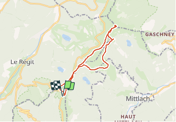
Randonnée Marche de 12,1 km à découvrir à Grand Est, Haut-Rhin, Wildenstein. Cette randonnée est proposée par Seppala - Balades du jeudi.
Description
Une balade en altitude avec départ sur la route des crêtes. 450 m de dénivelé, 12 km au total.
ACCÈS :
Par Guebwiller puis le Markstein, traverser la station de ski en direction du Hohneck-Munster.
Après environ 12 km sur la route des crêtes (D430) vous arrivez au parking.
Attention, il faut 40 mn à partir de Guebwiller.
PARKING: - sur la route des crêtes (D430) 200 m avant l'intersection avec la D583 en direction de La Bresse. Le parking est situé au-dessus de la maison de la nature du Rothenbach
48.005000, 6.978400 ou
N 48°00'18.0", E 6°58'42.2"
RESTAURATION :
Auberge du Pied du Hohneck.
Tél. 03 29 63 11 50
Localisation
Commentaires
Randonnées à proximité
![Randonnée Marche La Bresse - 2023-04-16 Marche Abri Lac de Blanchemer vers Lac de Lispach - Photo](https://media.geolcdn.com/t/375/260/20b642e6-a3a8-4790-bc8e-b2ad298c0408.jpg&format=jpg&maxdim=2)
![Marche Marche](https://static1.geolcdn.com/sitytour/trail-icons/101.png)
Marche
![](/images/other/stat-length.png)
![](https://static1.geolcdn.com/siteimages/upload/files/16400158638029165_repeat_loop_refresh_sync_direction_icon.png)
![Randonnée Marche La Bresse - 2023-04-15 Marche Abri Collet de Etang vers Abri Lac de Blanchemer - Photo](https://media.geolcdn.com/t/375/260/f5705708-8e73-435e-a1e8-28d1d0c03215.jpg&format=jpg&maxdim=2)
![Marche Marche](https://static1.geolcdn.com/sitytour/trail-icons/101.png)
Marche
![](/images/other/stat-length.png)
![](https://static1.geolcdn.com/siteimages/upload/files/16400158638029165_repeat_loop_refresh_sync_direction_icon.png)
![Randonnée Marche Wildenstein - 2022-02-20 Marche Kruth Grand Ventron - Photo](https://media.geolcdn.com/t/375/260/74324e84-ba09-479c-87ba-50417488039d.jpg&format=jpg&maxdim=2)
![Marche Marche](https://static1.geolcdn.com/sitytour/trail-icons/101.png)
Marche
![](/images/other/stat-length.png)
![](https://static1.geolcdn.com/siteimages/upload/files/16400158638029165_repeat_loop_refresh_sync_direction_icon.png)
![Randonnée Marche La Bresse - Kastelberg des pierres, des lacs, des panoramas magnifiques - Photo](https://media.geolcdn.com/t/375/260/cada329c-fae7-4d3f-815e-38ed5d6ce361.jpg&format=jpg&maxdim=2)
![Marche Marche](https://static1.geolcdn.com/sitytour/trail-icons/101.png)
Marche
![](/images/other/stat-length.png)
![](https://static1.geolcdn.com/siteimages/upload/files/16400158638029165_repeat_loop_refresh_sync_direction_icon.png)
![Randonnée Marche Wildenstein - TREK ALSACIEN (boucle de Wildenstein) - Photo](https://media.geolcdn.com/t/375/260/319755c6-b355-43a3-9980-ff414aa67ddf.jpg&format=jpg&maxdim=2)
![Marche Marche](https://static1.geolcdn.com/sitytour/trail-icons/101.png)
Marche
![](/images/other/stat-length.png)
![](https://static1.geolcdn.com/siteimages/upload/files/16400158638029165_repeat_loop_refresh_sync_direction_icon.png)
![Marche Marche](https://static1.geolcdn.com/sitytour/trail-icons/101.png)
Marche
![](/images/other/stat-length.png)
![](https://static1.geolcdn.com/siteimages/upload/files/16400158638029165_repeat_loop_refresh_sync_direction_icon.png)
![Randonnée Marche Wildenstein - Col du Bramont - Machey - Blanchemer - Photo](https://media.geolcdn.com/t/375/260/ext.jpg?maxdim=2&url=https%3A%2F%2Fservices.sitytrail.com%2FGeolivesWS%2FDownloadMedia.ashx%3FTrailID%3D450008%26Media%3Dfix__20150714143610.jpg)
![Marche Marche](https://static1.geolcdn.com/sitytour/trail-icons/101.png)
Marche
![](/images/other/stat-length.png)
![](https://static1.geolcdn.com/siteimages/upload/files/16400158638029165_repeat_loop_refresh_sync_direction_icon.png)
![Randonnée Marche La Bresse - lac de Lispach - Photo](https://media.geolcdn.com/t/375/260/ext.jpg?maxdim=2&url=https%3A%2F%2Fservices.sitytrail.com%2FGeolivesWS%2FDownloadMedia.ashx%3FTrailID%3D441673%26Media%3D20150705125536.jpg)
![Marche Marche](https://static1.geolcdn.com/sitytour/trail-icons/101.png)
Marche
![](/images/other/stat-length.png)
![](https://static1.geolcdn.com/siteimages/upload/files/16400158638029165_repeat_loop_refresh_sync_direction_icon.png)
![Randonnée Marche La Bresse - lac de Lispach - Photo](https://media.geolcdn.com/t/375/260/ext.jpg?maxdim=2&url=https%3A%2F%2Fservices.sitytrail.com%2FGeolivesWS%2FDownloadMedia.ashx%3FTrailID%3D441672%26Media%3D20150705124703.jpg)
![Marche Marche](https://static1.geolcdn.com/sitytour/trail-icons/101.png)
Marche
![](/images/other/stat-length.png)
![](https://static1.geolcdn.com/siteimages/upload/files/16400158638029165_repeat_loop_refresh_sync_direction_icon.png)
Très belle balade, avec un soleil magnifique la 30/07/2020