Accueil
World
NEW
Premium
Shop
Randonnées
Articles
Aide - support
Français
English
Nederlands
Español
Italiano
Deutsch
Connexion
Accueil
World
Premium
Shop
Randonnées
Articles
Aide - support
SityTrail
>
Points d'intérêt
>
GCVKWT
SityTrail
>
Points d'intérêt
>
GCVKWT
GCVKWT
Description
Bourgogne - Roche de Solutré b
Photos
GCVKWT est à découvrir dans les randonnées suivantes...
tracegps
Lac-Bleu depuis Méribel-Altiport
Marche
Difficile
(1)
Les Allues, Auvergne-Rhône-Alpes, Savoie, France
10 km | 18,1 km-effort
4h 30min
Oui
tracegps
Utilisateur
©
OpenStreetMap
contributors
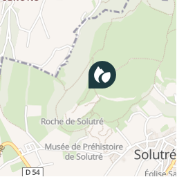
Localisation
Pays :
France
Région :
Bourgogne-Franche-Comté
Département/Province :
Saône-et-Loire
Commune :
Solutré-Pouilly
Localité :
Unknown
Localisation
46.299717 / 4.719167
Date de création :
2018-04-09 12:18:19.341
Dernière modification
2018-04-09 12:18:19.341
(0 Avis)
Commentaires
Veuillez vous connecter pour laisser un commentaire ou une note
Points d'intérêt à proximité
tracegps
GCVKWT
SOLUTRÉ-POUILLY
tracegps
GCVKWT
SOLUTRÉ-POUILLY
tracegps
GCVKWT
SOLUTRÉ-POUILLY
tracegps
GCVKWT
SOLUTRÉ-POUILLY
tracegps
GCVKWT
SOLUTRÉ-POUILLY
tracegps
GCVKWT
SOLUTRÉ-POUILLY
tracegps
GCVKWT
SOLUTRÉ-POUILLY
tracegps
GCVKWT
SOLUTRÉ-POUILLY
Fermer
Mes abonnements