![](/images/other/stat-length.png)
- Randonnées
- Outdoor
- Italie
- Ligurie
- La Spezia
La Spezia, Ligurie : Les meilleures randonnées, itinéraires, parcours, balades et promenades
La Spezia : découvrez les meilleures randonnées : 315 pédestres et 1 à vélo ou VTT. Tous ces circuits, parcours, itinéraires et activités en plein air sont disponibles dans nos applications SityTrail pour smartphones et tablettes.
Les meilleurs parcours (321)
![Randonnée Marche Vernazza - Rando cinq Terre 4ème jour Vernazza-Riomaggiore - Photo](https://media.geolcdn.com/t/350/260/f9331efa-b16c-4633-8239-c8a50683b624.jpg&format=jpg&maxdim=2)
![Marche Marche](https://static1.geolcdn.com/sitytour/trail-icons/101.png)
Km
Marche
![](/images/other/stat-length.png)
![](https://static1.geolcdn.com/siteimages/upload/files/1508320355ic_sort_den_pos_24dp.png)
![](https://static1.geolcdn.com/siteimages/upload/files/1508320355ic_sort_den_neg_24dp.png)
![](https://static1.geolcdn.com/siteimages/upload/files/16400158638029165_repeat_loop_refresh_sync_direction_icon.png)
![Randonnée Marche Vernazza - Fernacchi - manarola - Photo](https://media.geolcdn.com/t/350/260/ext.jpg?maxdim=2&url=https%3A%2F%2Fstatic1.geolcdn.com%2Fsiteimages%2Fupload%2Ffiles%2F1553511878bg_sport_marche.png)
![Marche Marche](https://static1.geolcdn.com/sitytour/trail-icons/101.png)
Km
Marche
![](/images/other/stat-length.png)
![](https://static1.geolcdn.com/siteimages/upload/files/1508320355ic_sort_den_pos_24dp.png)
![](https://static1.geolcdn.com/siteimages/upload/files/1508320355ic_sort_den_neg_24dp.png)
![](https://static1.geolcdn.com/siteimages/upload/files/16400158638029165_repeat_loop_refresh_sync_direction_icon.png)
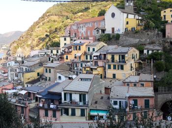
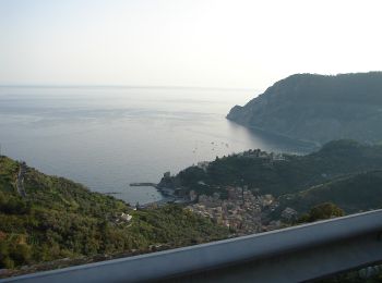
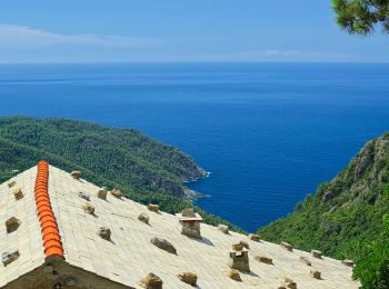
• Départ de herbergemnrt magnifique de ferncchi Remonté vers le col cigoletta puis vers le village manarola
![Randonnée Marche Levanto - Levanto - Vernazza 6.5.23 - Photo](https://media.geolcdn.com/t/350/260/0287dcd3-7795-4c8b-8f35-962c00e797c3.jpg&format=jpg&maxdim=2)
![Marche Marche](https://static1.geolcdn.com/sitytour/trail-icons/101.png)
Km
Marche
![](/images/other/stat-length.png)
![](https://static1.geolcdn.com/siteimages/upload/files/1508320355ic_sort_den_pos_24dp.png)
![](https://static1.geolcdn.com/siteimages/upload/files/1508320355ic_sort_den_neg_24dp.png)
![](https://static1.geolcdn.com/siteimages/upload/files/16400158638029165_repeat_loop_refresh_sync_direction_icon.png)
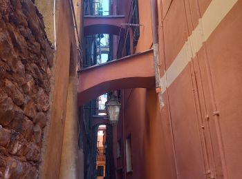
• Chemin évitant la route fréquentée.
![Randonnée A pied Riomaggiore - Sentiero Verde Azzurro: Riomaggiore - Monterosso - Photo](https://media.geolcdn.com/t/350/260/21e91162-0b70-4d8b-9c83-39f7fb798cc6.jpeg&format=jpg&maxdim=2)
![A pied A pied](https://static1.geolcdn.com/sitytour/trail-icons/100.png)
Km
A pied
![](/images/other/stat-length.png)
![](https://static1.geolcdn.com/siteimages/upload/files/1508320355ic_sort_den_pos_24dp.png)
![](https://static1.geolcdn.com/siteimages/upload/files/1508320355ic_sort_den_neg_24dp.png)
![](https://static1.geolcdn.com/siteimages/upload/files/16400158638029165_repeat_loop_refresh_sync_direction_icon.png)
• Google Earth photos (click on → Web site or Sito web) by Danilo (CAI Pallanza)
![Randonnée A pied La Spezia - Alta Via del Golfo: La Foce - Portovenere - Photo](https://media.geolcdn.com/t/350/260/ba716d0b-b060-4db4-8fd9-8ae9862dae50.jpeg&format=jpg&maxdim=2)
![A pied A pied](https://static1.geolcdn.com/sitytour/trail-icons/100.png)
Km
A pied
![](/images/other/stat-length.png)
![](https://static1.geolcdn.com/siteimages/upload/files/1508320355ic_sort_den_pos_24dp.png)
![](https://static1.geolcdn.com/siteimages/upload/files/1508320355ic_sort_den_neg_24dp.png)
![](https://static1.geolcdn.com/siteimages/upload/files/16400158638029165_repeat_loop_refresh_sync_direction_icon.png)
• relation mantained by AlfredoSP (CAI-SP) Symbole: AVG on white ref flag Site web: https://www.cailaspezia.it/
![Randonnée A pied Arcola - Alta Via del Golfo: Il Termo - La Foce - Photo](https://media.geolcdn.com/t/350/260/ba716d0b-b060-4db4-8fd9-8ae9862dae50.jpeg&format=jpg&maxdim=2)
![A pied A pied](https://static1.geolcdn.com/sitytour/trail-icons/100.png)
Km
A pied
![](/images/other/stat-length.png)
![](https://static1.geolcdn.com/siteimages/upload/files/1508320355ic_sort_den_pos_24dp.png)
![](https://static1.geolcdn.com/siteimages/upload/files/1508320355ic_sort_den_neg_24dp.png)
![](https://static1.geolcdn.com/siteimages/upload/files/16400158638029165_repeat_loop_refresh_sync_direction_icon.png)
• relation mantained by AlfredoSP (CAI-SP) Symbole: AVG on white ref flag Site web: https://www.cailaspezia.it/
![Randonnée A pied Ameglia - Alta Via del Golfo: Bocca di Magra - Il Termo - Photo](https://media.geolcdn.com/t/350/260/91145c2a-bb6c-4a98-a95f-74b9963415fb.jpeg&format=jpg&maxdim=2)
![A pied A pied](https://static1.geolcdn.com/sitytour/trail-icons/100.png)
Km
A pied
![](/images/other/stat-length.png)
![](https://static1.geolcdn.com/siteimages/upload/files/1508320355ic_sort_den_pos_24dp.png)
![](https://static1.geolcdn.com/siteimages/upload/files/1508320355ic_sort_den_neg_24dp.png)
![](https://static1.geolcdn.com/siteimages/upload/files/16400158638029165_repeat_loop_refresh_sync_direction_icon.png)
• relation mantained by AlfredoSP (CAI-SP) Symbole: AVG on white ref flag Site web: https://www.cailaspezia.it/
![Randonnée A pied Levanto - Alta Via delle 5 Terre: Foce di Dosso - Monte San Nicolao - Passo del Biscia - Photo](https://media.geolcdn.com/t/350/260/b0c8ac09-74d2-479f-a320-56bfabb8d7cd.jpeg&format=jpg&maxdim=2)
![A pied A pied](https://static1.geolcdn.com/sitytour/trail-icons/100.png)
Km
A pied
![](/images/other/stat-length.png)
![](https://static1.geolcdn.com/siteimages/upload/files/1508320355ic_sort_den_pos_24dp.png)
![](https://static1.geolcdn.com/siteimages/upload/files/1508320355ic_sort_den_neg_24dp.png)
![](https://static1.geolcdn.com/siteimages/upload/files/16400158638029165_repeat_loop_refresh_sync_direction_icon.png)
• relation mantained by AlfredoSP (CAI-SP) Symbole: AV5T on white red flag
![Randonnée A pied Riomaggiore - Alta Via delle 5 Terre: Portovenere - Monte Soviore - Foce di Dosso - Photo](https://media.geolcdn.com/t/350/260/456d2105-e49f-49c7-aec6-96ed27aa27d5.jpeg&format=jpg&maxdim=2)
![A pied A pied](https://static1.geolcdn.com/sitytour/trail-icons/100.png)
Km
A pied
![](/images/other/stat-length.png)
![](https://static1.geolcdn.com/siteimages/upload/files/1508320355ic_sort_den_pos_24dp.png)
![](https://static1.geolcdn.com/siteimages/upload/files/1508320355ic_sort_den_neg_24dp.png)
![](https://static1.geolcdn.com/siteimages/upload/files/16400158638029165_repeat_loop_refresh_sync_direction_icon.png)
• relation mantained by AlfredoSP (CAI-SP) Symbole: AV5T on white red flag
![Randonnée A pied Sesta Godano - Arsina - Carrodano Superiore - Mattarana - Colle Gruzze - San Nicolao - Photo](https://media.geolcdn.com/t/350/260/1750aa07-7dac-4e5d-9585-80377be893f7.jpeg&format=jpg&maxdim=2)
![A pied A pied](https://static1.geolcdn.com/sitytour/trail-icons/100.png)
Km
A pied
![](/images/other/stat-length.png)
![](https://static1.geolcdn.com/siteimages/upload/files/1508320355ic_sort_den_pos_24dp.png)
![](https://static1.geolcdn.com/siteimages/upload/files/1508320355ic_sort_den_neg_24dp.png)
![](https://static1.geolcdn.com/siteimages/upload/files/16400158638029165_repeat_loop_refresh_sync_direction_icon.png)
• relation mantained by AlfredoSP (CAI-SP) Symbole: unmarked Site web: https://www.cailaspezia.it/
![Randonnée A pied Maissana - La Mola – Valico della Foce – Costa Manteghea – Monte Vagie - Photo](https://media.geolcdn.com/t/350/260/360f65f8-7a1b-4bfb-9959-ff42251331a2.jpeg&format=jpg&maxdim=2)
![A pied A pied](https://static1.geolcdn.com/sitytour/trail-icons/100.png)
Km
A pied
![](/images/other/stat-length.png)
![](https://static1.geolcdn.com/siteimages/upload/files/1508320355ic_sort_den_pos_24dp.png)
![](https://static1.geolcdn.com/siteimages/upload/files/1508320355ic_sort_den_neg_24dp.png)
![](https://static1.geolcdn.com/siteimages/upload/files/16400158638029165_repeat_loop_refresh_sync_direction_icon.png)
• relation mantained by AlfredoSP (CAI-SP) Symbole: some old white red flag Site web: https://www.cailaspezia.it/
![Randonnée A pied Carro - Carro – Travo - Ziona – Case Luxiata – Colle Gruzze (Quattro Strade) - Photo](https://media.geolcdn.com/t/350/260/58618f47-6112-4047-83dc-28abba47be69.jpeg&format=jpg&maxdim=2)
![A pied A pied](https://static1.geolcdn.com/sitytour/trail-icons/100.png)
Km
A pied
![](/images/other/stat-length.png)
![](https://static1.geolcdn.com/siteimages/upload/files/1508320355ic_sort_den_pos_24dp.png)
![](https://static1.geolcdn.com/siteimages/upload/files/1508320355ic_sort_den_neg_24dp.png)
![](https://static1.geolcdn.com/siteimages/upload/files/16400158638029165_repeat_loop_refresh_sync_direction_icon.png)
• relation mantained by AlfredoSP (CAI-SP) Symbole: some old white red flag Site web: https://www.cailaspezia.it/
![Randonnée A pied Carro - Pavareto – Casun du Rissu – Colle Gruzze (Quattro Strade) - Photo](https://media.geolcdn.com/t/350/260/f43187b3-05f0-4e1d-ad74-3d495779203d.jpeg&format=jpg&maxdim=2)
![A pied A pied](https://static1.geolcdn.com/sitytour/trail-icons/100.png)
Km
A pied
![](/images/other/stat-length.png)
![](https://static1.geolcdn.com/siteimages/upload/files/1508320355ic_sort_den_pos_24dp.png)
![](https://static1.geolcdn.com/siteimages/upload/files/1508320355ic_sort_den_neg_24dp.png)
![](https://static1.geolcdn.com/siteimages/upload/files/16400158638029165_repeat_loop_refresh_sync_direction_icon.png)
• relation mantained by AlfredoSP (CAI-SP) Symbole: 621 on white red flag Site web: https://www.cailaspezia.it/
![Randonnée A pied Carro - Pavareto – La Mola – Sella Monte Stronzi - Photo](https://media.geolcdn.com/t/350/260/06791805-8d5c-4193-bace-a2b66b75f814.jpeg&format=jpg&maxdim=2)
![A pied A pied](https://static1.geolcdn.com/sitytour/trail-icons/100.png)
Km
A pied
![](/images/other/stat-length.png)
![](https://static1.geolcdn.com/siteimages/upload/files/1508320355ic_sort_den_pos_24dp.png)
![](https://static1.geolcdn.com/siteimages/upload/files/1508320355ic_sort_den_neg_24dp.png)
![](https://static1.geolcdn.com/siteimages/upload/files/16400158638029165_repeat_loop_refresh_sync_direction_icon.png)
• relation mantained by AlfredoSP (CAI-SP) Symbole: 620 on white red flag Site web: https://www.cailaspezia.it/
![Randonnée A pied Levanto - Vallesanta - Monte delle Streghe - Colletto - Photo](https://media.geolcdn.com/t/350/260/efa63fd2-8e4e-4cf6-bbf2-2f4e4541a575.jpeg&format=jpg&maxdim=2)
![A pied A pied](https://static1.geolcdn.com/sitytour/trail-icons/100.png)
Km
A pied
![](/images/other/stat-length.png)
![](https://static1.geolcdn.com/siteimages/upload/files/1508320355ic_sort_den_pos_24dp.png)
![](https://static1.geolcdn.com/siteimages/upload/files/1508320355ic_sort_den_neg_24dp.png)
![](https://static1.geolcdn.com/siteimages/upload/files/16400158638029165_repeat_loop_refresh_sync_direction_icon.png)
• relation mantained by AlfredoSP (CAI-SP) Symbole: likely unmarked Site web: https://www.cailaspezia.it/
![Randonnée A pied Bonassola - Reggimonti - Monte Gaggi - S.P. 64 - Monte Grumo - Photo](https://media.geolcdn.com/t/350/260/53b7c24f-114d-496d-8324-7d9132d796d3.jpeg&format=jpg&maxdim=2)
![A pied A pied](https://static1.geolcdn.com/sitytour/trail-icons/100.png)
Km
A pied
![](/images/other/stat-length.png)
![](https://static1.geolcdn.com/siteimages/upload/files/1508320355ic_sort_den_pos_24dp.png)
![](https://static1.geolcdn.com/siteimages/upload/files/1508320355ic_sort_den_neg_24dp.png)
![](https://static1.geolcdn.com/siteimages/upload/files/16400158638029165_repeat_loop_refresh_sync_direction_icon.png)
• relation mantained by AlfredoSP (CAI-SP) Symbole: unmarked Site web: https://www.cailaspezia.it/
![Randonnée A pied Bonassola - Bonassola - Salto della Lepre - Pastorelli - Montaretto - Photo](https://media.geolcdn.com/t/350/260/a7cea6e7-bc07-4258-9020-ad0c6abe0784.jpeg&format=jpg&maxdim=2)
![A pied A pied](https://static1.geolcdn.com/sitytour/trail-icons/100.png)
Km
A pied
![](/images/other/stat-length.png)
![](https://static1.geolcdn.com/siteimages/upload/files/1508320355ic_sort_den_pos_24dp.png)
![](https://static1.geolcdn.com/siteimages/upload/files/1508320355ic_sort_den_neg_24dp.png)
![](https://static1.geolcdn.com/siteimages/upload/files/16400158638029165_repeat_loop_refresh_sync_direction_icon.png)
• relation mantained by AlfredoSP (CAI-SP) Symbole: some old white red flag Site web: https://www.cailaspezia.it/
![Randonnée A pied Framura - Vandarecca - Montaretto - Reggimonti – Bivio AV5T - Photo](https://media.geolcdn.com/t/350/260/433b5181-ce40-4552-b8f8-d309475f0ca2.jpeg&format=jpg&maxdim=2)
![A pied A pied](https://static1.geolcdn.com/sitytour/trail-icons/100.png)
Km
A pied
![](/images/other/stat-length.png)
![](https://static1.geolcdn.com/siteimages/upload/files/1508320355ic_sort_den_pos_24dp.png)
![](https://static1.geolcdn.com/siteimages/upload/files/1508320355ic_sort_den_neg_24dp.png)
![](https://static1.geolcdn.com/siteimages/upload/files/16400158638029165_repeat_loop_refresh_sync_direction_icon.png)
• relation mantained by AlfredoSP (CAI-SP) Symbole: 660 on white red flag Site web: https://www.cailaspezia.it/
![Randonnée A pied Framura - Framura (Setta) - Costa - Rovereto - Castagnola - Monte Sant'Agata - Photo](https://media.geolcdn.com/t/350/260/f566bb7c-3946-4951-b36b-20a42e298c78.jpeg&format=jpg&maxdim=2)
![A pied A pied](https://static1.geolcdn.com/sitytour/trail-icons/100.png)
Km
A pied
![](/images/other/stat-length.png)
![](https://static1.geolcdn.com/siteimages/upload/files/1508320355ic_sort_den_pos_24dp.png)
![](https://static1.geolcdn.com/siteimages/upload/files/1508320355ic_sort_den_neg_24dp.png)
![](https://static1.geolcdn.com/siteimages/upload/files/16400158638029165_repeat_loop_refresh_sync_direction_icon.png)
• relation mantained by AlfredoSP (CAI-SP) Symbole: some old white red flag Site web: https://www.cailaspezia.it/
![Randonnée A pied Carrodano - Colle Gruzze (Quattro Strade) - Canegreca - Foce di Vaggi - Photo](https://media.geolcdn.com/t/350/260/f43187b3-05f0-4e1d-ad74-3d495779203d.jpeg&format=jpg&maxdim=2)
![A pied A pied](https://static1.geolcdn.com/sitytour/trail-icons/100.png)
Km
A pied
![](/images/other/stat-length.png)
![](https://static1.geolcdn.com/siteimages/upload/files/1508320355ic_sort_den_pos_24dp.png)
![](https://static1.geolcdn.com/siteimages/upload/files/1508320355ic_sort_den_neg_24dp.png)
![](https://static1.geolcdn.com/siteimages/upload/files/16400158638029165_repeat_loop_refresh_sync_direction_icon.png)
• relation mantained by AlfredoSP (CAI-SP) Symbole: unmarked Site web: https://www.cailaspezia.it/
20 randonnées affichées sur 321
Application GPS de randonnée GRATUITE
Activités
Régions proches
- Ameglia
- Arcola
- Beverino
- Bolano
- Bonassola
- Borghetto di Vara
- Brugnato
- Calice al Cornoviglio
- Carro
- Carrodano
- Castelnuovo Magra
- Deiva Marina
- Follo
- Framura
- La Spezia
- Lerici
- Levanto
- Luni
- Maissana
- Monterosso al Mare
- Pignone
- Portovenere
- Riccò del Golfo di Spezia
- Riomaggiore
- Rocchetta di Vara
- Santo Stefano di Magra
- Sarzana
- Sesta Godano
- Varese Ligure
- Vernazza
- Vezzano Ligure
- Zignago