


7,3 km | 7,8 km-effort
Westport-Belmullet Municipal District : découvrez les meilleures randonnées : 22 pédestres et 1 à vélo ou VTT. Tous ces circuits, parcours, itinéraires et activités en plein air sont disponibles dans nos applications SityTrail pour smartphones et tablettes.
A pied


• Site web: https://achilltourism.com/valley-loop-walk-sli-toin-a-tseanbhaile/
A pied
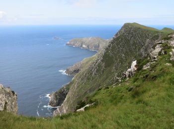
• Mayo offers most types of walking to include mountain and hill walks, coastal and island, rural and urban. The variet...
A pied
• Randonnée créée par Irish National Looped Walks.
A pied
• Randonnée créée par Irish National Looped Walks.
A pied
• Randonnée créée par Irish National Looped Walks.
A pied
• Mayo offers most types of walking to include mountain and hill walks, coastal and island, rural and urban. The variet...
A pied
A pied
A pied
A pied
• Randonnée créée par Slí na Sláinte - Irish Heart Foundation.
Marche
Marche
Marche
Marche
Marche

Marche
• Westport
Marche
• Walk Belderrig-Portulin loop on the North Mayo Cliffs (27km ~ 7 hours) Belderrig to Porturlin is a stunning cliff wal...

Autre activité
•
Marche

Moto
20 randonnées affichées sur 27
Application GPS de randonnée GRATUITE
 SityTrail
IGN / Instituts géographiques
SityTrail World
Le monde est à vous