![](/images/other/stat-length.png)
Lacommande, Pyrénées-Atlantiques : Les meilleures randonnées, itinéraires, parcours, balades et promenades
Lacommande : découvrez les meilleures randonnées : 3 pédestres. Tous ces circuits, parcours, itinéraires et activités en plein air sont disponibles dans nos applications SityTrail pour smartphones et tablettes.
Les meilleurs parcours (3)
![Randonnée Marche Lacommande - LACOMMANDE/HAUT D'ESTIALECQ balisage GR 653D - Photo](https://media.geolcdn.com/t/350/260/1b39619f-1e44-4079-beea-c45485a0014f.jpg&format=jpg&maxdim=2)
![Marche Marche](https://static1.geolcdn.com/sitytour/trail-icons/101.png)
Km
#1 - LACOMMANDE/HAUT D'ESTIALECQ balisage GR 653D
Marche
Difficile
Lacommande,
Nouvelle-Aquitaine,
Pyrénées-Atlantiques,
France
![](/images/other/stat-length.png)
10,2 km | 14,8 km-effort
2h 58min
![](https://static1.geolcdn.com/siteimages/upload/files/1508320355ic_sort_den_pos_24dp.png)
395 m
![](https://static1.geolcdn.com/siteimages/upload/files/1508320355ic_sort_den_neg_24dp.png)
205 m
![](https://static1.geolcdn.com/siteimages/upload/files/16400158638029165_repeat_loop_refresh_sync_direction_icon.png)
Non
marmotte65
![Randonnée Marche Lacommande - La voie d'Arles de Lacommande à Oloron - Photo](https://media.geolcdn.com/t/350/260/ext.jpg?maxdim=2&url=https%3A%2F%2Fservices.sitytrail.com%2FGeolivesWS%2FDownloadMedia.ashx%3FTrailID%3D108688%26Media%3D1727_2.jpg)
![Marche Marche](https://static1.geolcdn.com/sitytour/trail-icons/101.png)
Km
#2 - La voie d'Arles de Lacommande à Oloron
Marche
Difficile
Lacommande,
Nouvelle-Aquitaine,
Pyrénées-Atlantiques,
France
![](/images/other/stat-length.png)
15,2 km | 22 km-effort
3h 0min
![](https://static1.geolcdn.com/siteimages/upload/files/1508320355ic_sort_den_pos_24dp.png)
587 m
![](https://static1.geolcdn.com/siteimages/upload/files/1508320355ic_sort_den_neg_24dp.png)
410 m
![](https://static1.geolcdn.com/siteimages/upload/files/16400158638029165_repeat_loop_refresh_sync_direction_icon.png)
Non
tracegps
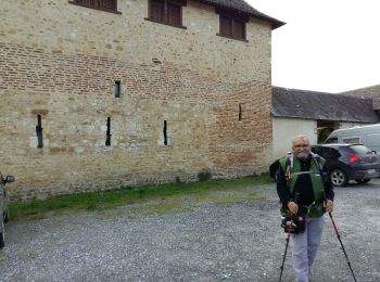
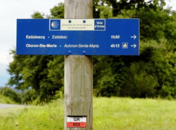
• Lacommande à Oloron Ste Marie L’ancienne commanderie veillait à la sécurité des Pèlerins de Compostelle sur la voie d...
![Randonnée Marche Lacommande - Trace G3 Lacommande Guy - Photo](https://media.geolcdn.com/t/350/260/ext.jpg?maxdim=2&url=https%3A%2F%2Fstatic1.geolcdn.com%2Fsiteimages%2Fupload%2Ffiles%2F1553511878bg_sport_marche.png)
![Marche Marche](https://static1.geolcdn.com/sitytour/trail-icons/101.png)
Km
#3 - Trace G3 Lacommande Guy
Marche
Lacommande,
Nouvelle-Aquitaine,
Pyrénées-Atlantiques,
France
![](/images/other/stat-length.png)
13,4 km | 18,2 km-effort
5h 12min
![](https://static1.geolcdn.com/siteimages/upload/files/1508320355ic_sort_den_pos_24dp.png)
362 m
![](https://static1.geolcdn.com/siteimages/upload/files/1508320355ic_sort_den_neg_24dp.png)
362 m
![](https://static1.geolcdn.com/siteimages/upload/files/16400158638029165_repeat_loop_refresh_sync_direction_icon.png)
Oui
mitch1952
3 randonnées affichées sur 3
Application GPS de randonnée GRATUITE