![](/images/other/stat-length.png)
- Randonnées
- Outdoor
- France
- Bourgogne-Franche-Comté
- Côte-d'Or
- Vic-sous-Thil
Vic-sous-Thil, Côte-d'Or : Les meilleures randonnées, itinéraires, parcours, balades et promenades
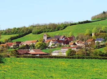
Vic-sous-Thil : découvrez les meilleures randonnées : 5 pédestres. Tous ces circuits, parcours, itinéraires et activités en plein air sont disponibles dans nos applications SityTrail pour smartphones et tablettes.
Les meilleurs parcours (5)
![Randonnée A pied Vic-sous-Thil - Les Trois Buttes - Photo](https://media.geolcdn.com/t/350/260/d697b441-ed0e-4bb7-9848-9caf418d2cb7.jpeg&format=jpg&maxdim=2)
![A pied A pied](https://static1.geolcdn.com/sitytour/trail-icons/100.png)
Km
A pied
![](/images/other/stat-length.png)
![](https://static1.geolcdn.com/siteimages/upload/files/1508320355ic_sort_den_pos_24dp.png)
![](https://static1.geolcdn.com/siteimages/upload/files/1508320355ic_sort_den_neg_24dp.png)
![](https://static1.geolcdn.com/siteimages/upload/files/16400158638029165_repeat_loop_refresh_sync_direction_icon.png)
• Randonnée créée par Côte d'Or Tourisme.
![Randonnée A pied Vic-sous-Thil - En Galafre - Photo](https://media.geolcdn.com/t/350/260/d24db1bc-de3f-42e1-9464-f1c619bfc440.jpeg&format=jpg&maxdim=2)
![A pied A pied](https://static1.geolcdn.com/sitytour/trail-icons/100.png)
Km
A pied
![](/images/other/stat-length.png)
![](https://static1.geolcdn.com/siteimages/upload/files/1508320355ic_sort_den_pos_24dp.png)
![](https://static1.geolcdn.com/siteimages/upload/files/1508320355ic_sort_den_neg_24dp.png)
![](https://static1.geolcdn.com/siteimages/upload/files/16400158638029165_repeat_loop_refresh_sync_direction_icon.png)
• Randonnée créée par Côte d'Or Tourisme.
![Randonnée Marche Vic-sous-Thil - Marche Expérimentale Légion VIII Augusta - Château de Thil - Château de Ste Colombe - Photo](https://media.geolcdn.com/t/350/260/ext.jpg?maxdim=2&url=https%3A%2F%2Fservices.sitytrail.com%2FGeolivesWS%2FDownloadMedia.ashx%3FTrailID%3D214883%26Media%3D15430_3.jpg)
![Marche Marche](https://static1.geolcdn.com/sitytour/trail-icons/101.png)
Km
Marche
![](/images/other/stat-length.png)
![](https://static1.geolcdn.com/siteimages/upload/files/1508320355ic_sort_den_pos_24dp.png)
![](https://static1.geolcdn.com/siteimages/upload/files/1508320355ic_sort_den_neg_24dp.png)
![](https://static1.geolcdn.com/siteimages/upload/files/16400158638029165_repeat_loop_refresh_sync_direction_icon.png)
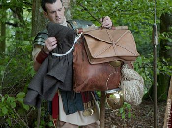
• En 52 avant J.C., après le siège d'Alésia, un général de Jules César et vétéran romain nommé Flavinius, se voit offri...
![Randonnée Marche Vic-sous-Thil - tilf - Photo](https://media.geolcdn.com/t/350/260/2384d343-b855-468b-832a-642844e2a116.jpg&format=jpg&maxdim=2)
![Marche Marche](https://static1.geolcdn.com/sitytour/trail-icons/101.png)
Km
Marche
![](/images/other/stat-length.png)
![](https://static1.geolcdn.com/siteimages/upload/files/1508320355ic_sort_den_pos_24dp.png)
![](https://static1.geolcdn.com/siteimages/upload/files/1508320355ic_sort_den_neg_24dp.png)
![](https://static1.geolcdn.com/siteimages/upload/files/16400158638029165_repeat_loop_refresh_sync_direction_icon.png)
![Randonnée Marche Vic-sous-Thil - w-frankrijk-vic-sous-thil-morvan - Photo](https://media.geolcdn.com/t/350/260/ext.jpg?maxdim=2&url=https%3A%2F%2Fstatic1.geolcdn.com%2Fsiteimages%2Fupload%2Ffiles%2F1553511878bg_sport_marche.png)
![Marche Marche](https://static1.geolcdn.com/sitytour/trail-icons/101.png)
Km
Marche
![](/images/other/stat-length.png)
![](https://static1.geolcdn.com/siteimages/upload/files/1508320355ic_sort_den_pos_24dp.png)
![](https://static1.geolcdn.com/siteimages/upload/files/1508320355ic_sort_den_neg_24dp.png)
![](https://static1.geolcdn.com/siteimages/upload/files/16400158638029165_repeat_loop_refresh_sync_direction_icon.png)
• More information on GPStracks.nl : http://www.gpstracks.nl
5 randonnées affichées sur 5
Application GPS de randonnée GRATUITE