


10 km | 11,3 km-effort
Bellevigne-en-Layon : découvrez les meilleures randonnées : 41 pédestres et 4 à vélo ou VTT. Tous ces circuits, parcours, itinéraires et activités en plein air sont disponibles dans nos applications SityTrail pour smartphones et tablettes.

Marche


Marche
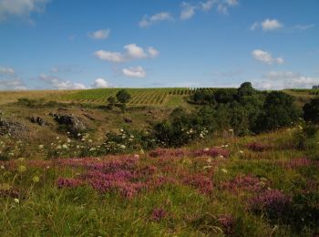
• Entre Rablay dur layon et Faye d'Anjou. Belle randonnée variée, et de jolis points de vue sur les coteaux du Layon.
A pied
• Randonnée créée par Communauté de commune Loire Layon Aubance.
Marche
• Circuit des Mailles
Marche
• Un chemin une ecole
Marche
• Entre les vignobles
Marche
• Circuit proposé par la Communauté de Communes des coteaux du Layon et l’Office de tourisme Beaulieu sur Layon. Départ...
Marche
Marche

A pied
• Randonnée créée par Communauté de commune Loire Layon Aubance.
Marche
Marche
Marche
• A travers les vignes, vous cheminerez à la découverte des paysages vallonés des coteaux du layon et du fabuleux terro...
Marche
• Cet itinéraire riche en moulins et châteaux vous fait cheminer de vallons en côteaux et de vignobles en cultures où v...
V.T.T.
• Circuit VTT facile entre Angers et Rablay sur Layon en suivant tout d'abord la Maine puis la Loire jusqu'au Pont de C...
V.T.T.
• Espace VTT - FFC des Coteaux du Layon Circuit labellisé par la Fédération Française de Cyclisme. Circuit entre vigns ...
Marche
• Jolie rando au départ de Rablay sur layon qui évite la ligne droite le long du layon au départ, par contre belle mont...
Marche
• Entre Rablay dur layon et Faye d'Anjou. Belle randonnée variée, et de jolis points de vue sur les coteaux du Layon.

 16.073
sport
• Ponctué d'éléments architecturaux notables, cet itinéraire offre également un paysage ouvert et varié : vue panoramiq...
Marche
20 randonnées affichées sur 47
Application GPS de randonnée GRATUITE
 SityTrail
IGN / Instituts géographiques
SityTrail World
Le monde est à vous