


9 km | 17,7 km-effort
Peipin : découvrez les meilleures randonnées : 18 pédestres, 2 à vélo ou VTT et 1 parcours équestres. Tous ces circuits, parcours, itinéraires et activités en plein air sont disponibles dans nos applications SityTrail pour smartphones et tablettes.

Marche


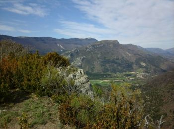
• MAGNIFIQUE

Marche
• 14.5 kms 3 H 20 mns marche 350 me dénivelé AR agréable
Marche
• Tres belle rando
Marche

Marche

Marche
Marche
Marche
Marche
• facile 280 mns marche 18 kms 300 M dénivelé
Autre activité
Marche
• Montée en terrain découvert chemin caillouteux Descente en sous bois, sentier avec feuilles Le temps inclus l’arrêt P...

A pied
A pied
Marche
• petite balade sympa
Marche

V.T.C.
V.T.C.

Randonnée équestre
Marche
Autre activité
20 randonnées affichées sur 23
Application GPS de randonnée GRATUITE
 SityTrail
IGN / Instituts géographiques
SityTrail World
Le monde est à vous