![](/images/other/stat-length.png)
- Randonnées
- Outdoor
- France
- Provence-Alpes-Côte d'Azur
- Var
- Bormes-les-Mimosas
Bormes-les-Mimosas, Var : Les meilleures randonnées, itinéraires, parcours, balades et promenades
Bormes-les-Mimosas : découvrez les meilleures randonnées : 300 pédestres et 35 à vélo ou VTT. Tous ces circuits, parcours, itinéraires et activités en plein air sont disponibles dans nos applications SityTrail pour smartphones et tablettes.
Les meilleurs parcours (355)
![Marche Marche](https://static1.geolcdn.com/sitytour/trail-icons/101.png)
Km
Marche
![](/images/other/stat-length.png)
![](https://static1.geolcdn.com/siteimages/upload/files/1508320355ic_sort_den_pos_24dp.png)
![](https://static1.geolcdn.com/siteimages/upload/files/1508320355ic_sort_den_neg_24dp.png)
![](https://static1.geolcdn.com/siteimages/upload/files/16400158638029165_repeat_loop_refresh_sync_direction_icon.png)
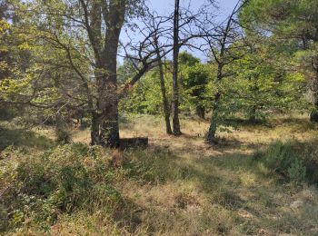
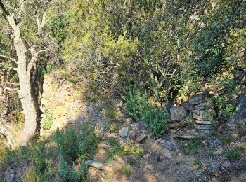
• Malgré son apparence aujourd'hui déserte la forêt du massif des Maures recèle de nombreux vestiges d'une occupation a...
![Randonnée Marche Bormes-les-Mimosas - Bormes les Mimosas - ND de Constance - Cols de Caguo Ven et Landon - Pierre d'avenon - Photo](https://media.geolcdn.com/t/350/260/c3cd69d2-66a0-450a-95c5-e8005107dd21.jpg&format=jpg&maxdim=2)
![Marche Marche](https://static1.geolcdn.com/sitytour/trail-icons/101.png)
Km
Marche
![](/images/other/stat-length.png)
![](https://static1.geolcdn.com/siteimages/upload/files/1508320355ic_sort_den_pos_24dp.png)
![](https://static1.geolcdn.com/siteimages/upload/files/1508320355ic_sort_den_neg_24dp.png)
![](https://static1.geolcdn.com/siteimages/upload/files/16400158638029165_repeat_loop_refresh_sync_direction_icon.png)
![Randonnée Marche Bormes-les-Mimosas - Bargean - Pt Noyer - Radar - Crêtes - Pera - Retenue Gd Noyer - Bargean - Photo](https://media.geolcdn.com/t/350/260/3db88ff5-5d2e-4949-8a29-14c430fd8c8f.jpg&format=jpg&maxdim=2)
![Marche Marche](https://static1.geolcdn.com/sitytour/trail-icons/101.png)
Km
Marche
![](/images/other/stat-length.png)
![](https://static1.geolcdn.com/siteimages/upload/files/1508320355ic_sort_den_pos_24dp.png)
![](https://static1.geolcdn.com/siteimages/upload/files/1508320355ic_sort_den_neg_24dp.png)
![](https://static1.geolcdn.com/siteimages/upload/files/16400158638029165_repeat_loop_refresh_sync_direction_icon.png)
![Randonnée Marche Bormes-les-Mimosas - Chartreuse de la Verne - Photo](https://media.geolcdn.com/t/350/260/ext.jpg?maxdim=2&url=https%3A%2F%2Fservices.sitytrail.com%2FGeolivesWS%2FDownloadMedia.ashx%3FTrailID%3D898630%26Media%3Dfix__20170215102107.jpg)
![Marche Marche](https://static1.geolcdn.com/sitytour/trail-icons/101.png)
Km
Marche
![](/images/other/stat-length.png)
![](https://static1.geolcdn.com/siteimages/upload/files/1508320355ic_sort_den_pos_24dp.png)
![](https://static1.geolcdn.com/siteimages/upload/files/1508320355ic_sort_den_neg_24dp.png)
![](https://static1.geolcdn.com/siteimages/upload/files/16400158638029165_repeat_loop_refresh_sync_direction_icon.png)
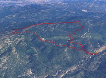
• D559 - D98 - départ à Bargean - le grand noyer -sommet du Péra -route de la Crête- Chartreuse de la Verne Retour par ...
![Randonnée Marche Bormes-les-Mimosas - Bormes les Mimosas et la Forêt des Maures - Photo](https://media.geolcdn.com/t/350/260/ext.jpg?maxdim=2&url=https%3A%2F%2Fservices.sitytrail.com%2FGeolivesWS%2FDownloadMedia.ashx%3FTrailID%3D103786%26Media%3D6556_2.jpg)
![Marche Marche](https://static1.geolcdn.com/sitytour/trail-icons/101.png)
Km
Marche
![](/images/other/stat-length.png)
![](https://static1.geolcdn.com/siteimages/upload/files/1508320355ic_sort_den_pos_24dp.png)
![](https://static1.geolcdn.com/siteimages/upload/files/1508320355ic_sort_den_neg_24dp.png)
![](https://static1.geolcdn.com/siteimages/upload/files/16400158638029165_repeat_loop_refresh_sync_direction_icon.png)
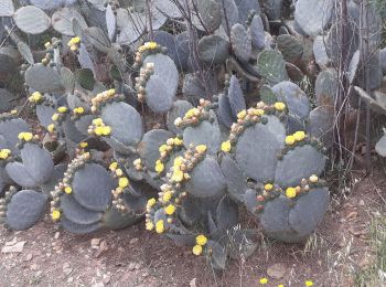
• Belle randonnée à faire de préférence quand les mimosas sont en fleurs (février mars). Niveau de difficulté 4. Parkin...
![Randonnée Marche Bormes-les-Mimosas - Tour de Bormes - Photo](https://media.geolcdn.com/t/350/260/ext.jpg?maxdim=2&url=https%3A%2F%2Fstatic1.geolcdn.com%2Fsiteimages%2Fupload%2Ffiles%2F1553511878bg_sport_marche.png)
![Marche Marche](https://static1.geolcdn.com/sitytour/trail-icons/101.png)
Km
Marche
![](/images/other/stat-length.png)
![](https://static1.geolcdn.com/siteimages/upload/files/1508320355ic_sort_den_pos_24dp.png)
![](https://static1.geolcdn.com/siteimages/upload/files/1508320355ic_sort_den_neg_24dp.png)
![](https://static1.geolcdn.com/siteimages/upload/files/16400158638029165_repeat_loop_refresh_sync_direction_icon.png)
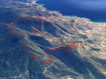
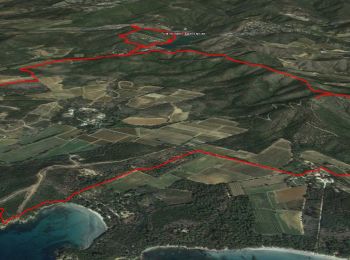
• Randonnée mixte entre crêtes avec vue sur Bormes et sentier littoral. De retour vers le lac, éviter de faire le tou...
![Randonnée Trail Bormes-les-Mimosas - Pointe du Diable et de Estagnol - Photo](https://media.geolcdn.com/t/350/260/ea478b0f-bf14-4a5a-bcc7-6189a705ccc7.jpg&format=jpg&maxdim=2)
![Trail Trail](https://static1.geolcdn.com/sitytour/trail-icons/104.png)
Km
Trail
![](/images/other/stat-length.png)
![](https://static1.geolcdn.com/siteimages/upload/files/1508320355ic_sort_den_pos_24dp.png)
![](https://static1.geolcdn.com/siteimages/upload/files/1508320355ic_sort_den_neg_24dp.png)
![](https://static1.geolcdn.com/siteimages/upload/files/16400158638029165_repeat_loop_refresh_sync_direction_icon.png)
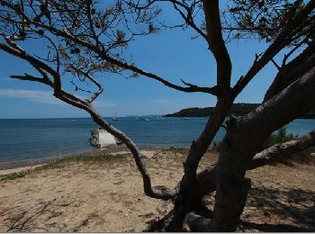
• assez varié et Petite baignade bien appréciée
![Randonnée Marche Bormes-les-Mimosas - Barrage du Trapan - Pellegrin - Photo](https://media.geolcdn.com/t/350/260/ebe11e5b-c00f-4172-b479-00c30bf032ed.jpg&format=jpg&maxdim=2)
![Marche Marche](https://static1.geolcdn.com/sitytour/trail-icons/101.png)
Km
Marche
![](/images/other/stat-length.png)
![](https://static1.geolcdn.com/siteimages/upload/files/1508320355ic_sort_den_pos_24dp.png)
![](https://static1.geolcdn.com/siteimages/upload/files/1508320355ic_sort_den_neg_24dp.png)
![](https://static1.geolcdn.com/siteimages/upload/files/16400158638029165_repeat_loop_refresh_sync_direction_icon.png)
• Privilégier le mois de février pour la floraison des mimosas ...
![Randonnée Marche Bormes-les-Mimosas - Bormes les Mimosas Les 3 Cols - Photo](https://media.geolcdn.com/t/350/260/23bdb278-92e8-4d98-83cb-eb5b5435fc48.jpg&format=jpg&maxdim=2)
![Marche Marche](https://static1.geolcdn.com/sitytour/trail-icons/101.png)
Km
Marche
![](/images/other/stat-length.png)
![](https://static1.geolcdn.com/siteimages/upload/files/1508320355ic_sort_den_pos_24dp.png)
![](https://static1.geolcdn.com/siteimages/upload/files/1508320355ic_sort_den_neg_24dp.png)
![](https://static1.geolcdn.com/siteimages/upload/files/16400158638029165_repeat_loop_refresh_sync_direction_icon.png)
• Départ parking St François (43°09'02''N / 006°20'41''E) 5Topo Guide le Var à Pied)
![Randonnée Marche Bormes-les-Mimosas - Barrage du Trapan - Estagnol - Pellegrin - Photo](https://media.geolcdn.com/t/350/260/313e00c8-6453-4b42-83e0-fd33fc6b49b0.jpg&format=jpg&maxdim=2)
![Marche Marche](https://static1.geolcdn.com/sitytour/trail-icons/101.png)
Km
Marche
![](/images/other/stat-length.png)
![](https://static1.geolcdn.com/siteimages/upload/files/1508320355ic_sort_den_pos_24dp.png)
![](https://static1.geolcdn.com/siteimages/upload/files/1508320355ic_sort_den_neg_24dp.png)
![](https://static1.geolcdn.com/siteimages/upload/files/16400158638029165_repeat_loop_refresh_sync_direction_icon.png)
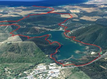
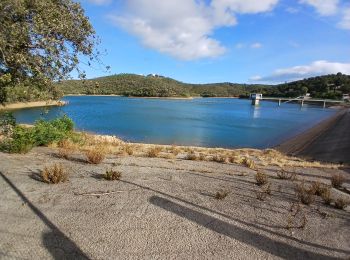
• La sortie de ce jeudi 11 02 2021: Le barrage du Trapan et le tour du domaine de Leoube en passant par les plages de l...
![Randonnée Marche Bormes-les-Mimosas - Col du Gratteloup - Piste domaniale Sud - Cols de Labade et Landon - Pierre d'Avenon - GR51/90 - Photo](https://media.geolcdn.com/t/350/260/a68a068d-d9c5-4471-8f2a-bbfabcb93eed.jpg&format=jpg&maxdim=2)
![Marche Marche](https://static1.geolcdn.com/sitytour/trail-icons/101.png)
Km
Marche
![](/images/other/stat-length.png)
![](https://static1.geolcdn.com/siteimages/upload/files/1508320355ic_sort_den_pos_24dp.png)
![](https://static1.geolcdn.com/siteimages/upload/files/1508320355ic_sort_den_neg_24dp.png)
![](https://static1.geolcdn.com/siteimages/upload/files/16400158638029165_repeat_loop_refresh_sync_direction_icon.png)
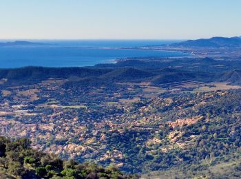
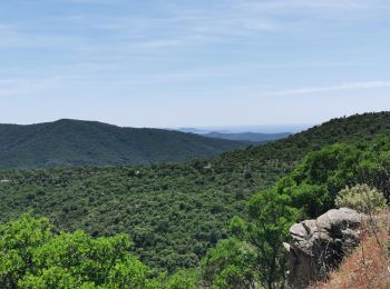
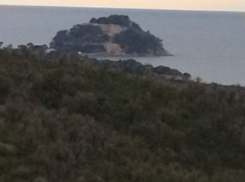
• Jolie boucle sur les hauteurs de Bormes les Mimosas. De beaux points de vue sur les Iles d'Hyères. Prendre le temps d...
![Randonnée Marche Bormes-les-Mimosas - Boucle : Pont des Caunes - Piste de l'Amandier - Piste de la Gourre - Piste Lambert - Col de la Citadelle - Pont des Caunes. - Photo](https://media.geolcdn.com/t/350/260/93e7f835-4806-4284-8793-c12d2410b0fc.jpg&format=jpg&maxdim=2)
![Marche Marche](https://static1.geolcdn.com/sitytour/trail-icons/101.png)
Km
Marche
![](/images/other/stat-length.png)
![](https://static1.geolcdn.com/siteimages/upload/files/1508320355ic_sort_den_pos_24dp.png)
![](https://static1.geolcdn.com/siteimages/upload/files/1508320355ic_sort_den_neg_24dp.png)
![](https://static1.geolcdn.com/siteimages/upload/files/16400158638029165_repeat_loop_refresh_sync_direction_icon.png)
• Randonnée sans aucune difficulté. Pas très ombragée. Ruisseaux à sec en cette période (septembre) dommage, pas de cas...
![Randonnée Marche Bormes-les-Mimosas - Le lac du Trapan - Photo](https://media.geolcdn.com/t/350/260/ext.jpg?maxdim=2&url=https%3A%2F%2Fservices.sitytrail.com%2FGeolivesWS%2FDownloadMedia.ashx%3FTrailID%3D452325%26Media%3D9e2d6742-85b3-4012-991e-d22c6e0c5c2a.jpg)
![Marche Marche](https://static1.geolcdn.com/sitytour/trail-icons/101.png)
Km
Marche
![](/images/other/stat-length.png)
![](https://static1.geolcdn.com/siteimages/upload/files/1508320355ic_sort_den_pos_24dp.png)
![](https://static1.geolcdn.com/siteimages/upload/files/1508320355ic_sort_den_neg_24dp.png)
![](https://static1.geolcdn.com/siteimages/upload/files/16400158638029165_repeat_loop_refresh_sync_direction_icon.png)
• Une rando pédestre ou en VTT .la rando avec des panoramas sur la côte st sur les île d or et sur la baie de Bormes le...
![Randonnée Marche Bormes-les-Mimosas - Pointe de l'Esquillette - Photo](https://media.geolcdn.com/t/350/260/ext.jpg?maxdim=2&url=https%3A%2F%2Fservices.sitytrail.com%2FGeolivesWS%2FDownloadMedia.ashx%3FTrailID%3D452318%26Media%3D2547c89e-032f-46f3-adb2-742ec3878938.jpg)
![Marche Marche](https://static1.geolcdn.com/sitytour/trail-icons/101.png)
Km
Marche
![](/images/other/stat-length.png)
![](https://static1.geolcdn.com/siteimages/upload/files/1508320355ic_sort_den_pos_24dp.png)
![](https://static1.geolcdn.com/siteimages/upload/files/1508320355ic_sort_den_neg_24dp.png)
![](https://static1.geolcdn.com/siteimages/upload/files/16400158638029165_repeat_loop_refresh_sync_direction_icon.png)
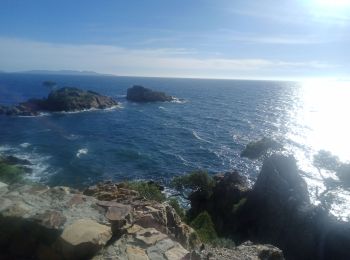
• Une rando avec des sentier taillé dans la roches.Tantôt au niveaux de la meret en suite au niveaux d' épis rocheux.av...
![Randonnée V.T.T. Bormes-les-Mimosas - lavandou5 - Photo](https://media.geolcdn.com/t/350/260/ext.jpg?maxdim=2&url=https%3A%2F%2Fstatic1.geolcdn.com%2Fsiteimages%2Fupload%2Ffiles%2F1524743154velo.jpg)
![V.T.T. V.T.T.](https://static1.geolcdn.com/sitytour/trail-icons/202.png)
Km
V.T.T.
![](/images/other/stat-length.png)
![](https://static1.geolcdn.com/siteimages/upload/files/1508320355ic_sort_den_pos_24dp.png)
![](https://static1.geolcdn.com/siteimages/upload/files/1508320355ic_sort_den_neg_24dp.png)
![](https://static1.geolcdn.com/siteimages/upload/files/16400158638029165_repeat_loop_refresh_sync_direction_icon.png)
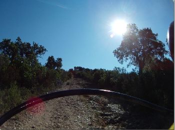
• 670 m de dénivelé positif. Prendre la boucle par la gauche. Parcours sans difficulté technique. 6 km de pistes cyclab...
![Randonnée Marche Bormes-les-Mimosas - Barrage du Trapan 10-01-2025 - Photo](https://media.geolcdn.com/t/350/260/bbd7ee92-d814-40ba-8b63-839249d00720.jpg&format=jpg&maxdim=2)
![Marche Marche](https://static1.geolcdn.com/sitytour/trail-icons/101.png)
Km
Marche
![](/images/other/stat-length.png)
![](https://static1.geolcdn.com/siteimages/upload/files/1508320355ic_sort_den_pos_24dp.png)
![](https://static1.geolcdn.com/siteimages/upload/files/1508320355ic_sort_den_neg_24dp.png)
![](https://static1.geolcdn.com/siteimages/upload/files/16400158638029165_repeat_loop_refresh_sync_direction_icon.png)
• Départ PK le long de la piste cyclable, tour du barrage du Trapan.
![Randonnée Marche Bormes-les-Mimosas - Vallons de la Gourre et des Caunes - Photo](https://media.geolcdn.com/t/350/260/1e74f8dd-3531-46df-bd25-c87eb6eff58d.jpg&format=jpg&maxdim=2)
![Marche Marche](https://static1.geolcdn.com/sitytour/trail-icons/101.png)
Km
Marche
![](/images/other/stat-length.png)
![](https://static1.geolcdn.com/siteimages/upload/files/1508320355ic_sort_den_pos_24dp.png)
![](https://static1.geolcdn.com/siteimages/upload/files/1508320355ic_sort_den_neg_24dp.png)
![](https://static1.geolcdn.com/siteimages/upload/files/16400158638029165_repeat_loop_refresh_sync_direction_icon.png)
• Belle randonnée avec le Touring Club du Var, dans la forêt des Maures, à proximité du col de Grateloup. Merci à nos a...
![Randonnée Marche Bormes-les-Mimosas - Bormes-les-Mimosas lac du Trapan (par la gauche), barrage. - Photo](https://media.geolcdn.com/t/350/260/fb211a63-e0a7-49cc-b944-3f4dbbe44a28.jpg&format=jpg&maxdim=2)
![Marche Marche](https://static1.geolcdn.com/sitytour/trail-icons/101.png)
Km
Marche
![](/images/other/stat-length.png)
![](https://static1.geolcdn.com/siteimages/upload/files/1508320355ic_sort_den_pos_24dp.png)
![](https://static1.geolcdn.com/siteimages/upload/files/1508320355ic_sort_den_neg_24dp.png)
![](https://static1.geolcdn.com/siteimages/upload/files/16400158638029165_repeat_loop_refresh_sync_direction_icon.png)
• En cette période, tous les mimosas en fleur, c'est superbe😊
![Randonnée Marche Bormes-les-Mimosas - Forêt du Dom - Photo](https://media.geolcdn.com/t/350/260/841c4ef1-7709-4d94-8f70-350221799c2e.jpg&format=jpg&maxdim=2)
![Marche Marche](https://static1.geolcdn.com/sitytour/trail-icons/101.png)
Km
Marche
![](/images/other/stat-length.png)
![](https://static1.geolcdn.com/siteimages/upload/files/1508320355ic_sort_den_pos_24dp.png)
![](https://static1.geolcdn.com/siteimages/upload/files/1508320355ic_sort_den_neg_24dp.png)
![](https://static1.geolcdn.com/siteimages/upload/files/16400158638029165_repeat_loop_refresh_sync_direction_icon.png)
• Trés belle rando, début février par une température digne d'une fin avril...
![Randonnée Marche Bormes-les-Mimosas - Bormes Les Mimosas Tour de la Berle - Photo](https://media.geolcdn.com/t/350/260/4a054b46-625f-47d8-89f6-dde42bf69cb6.jpg&format=jpg&maxdim=2)
![Marche Marche](https://static1.geolcdn.com/sitytour/trail-icons/101.png)
Km
Marche
![](/images/other/stat-length.png)
![](https://static1.geolcdn.com/siteimages/upload/files/1508320355ic_sort_den_pos_24dp.png)
![](https://static1.geolcdn.com/siteimages/upload/files/1508320355ic_sort_den_neg_24dp.png)
![](https://static1.geolcdn.com/siteimages/upload/files/16400158638029165_repeat_loop_refresh_sync_direction_icon.png)
• Suite à la réalisation d'une piste DFCI, disparition de plusieurs sentiers, en forêt, entrainant beaucoup de baragnes.
20 randonnées affichées sur 355
Application GPS de randonnée GRATUITE