![](/images/other/stat-length.png)
- Randonnées
- Outdoor
- France
- Grand Est
- Aube
Aube, Grand Est : Les meilleures randonnées, itinéraires, parcours, balades et promenades
Aube : découvrez les meilleures randonnées : 1 672 pédestres et 265 à vélo ou VTT. Tous ces circuits, parcours, itinéraires et activités en plein air sont disponibles dans nos applications SityTrail pour smartphones et tablettes.
Les meilleurs parcours (2012)
![Randonnée Marche Dienville - Dienville pour le Matin - Photo](https://media.geolcdn.com/t/350/260/c60828f8-5748-4aec-bc0b-8a0ab51d7958.jpg&format=jpg&maxdim=2)
![Marche Marche](https://static1.geolcdn.com/sitytour/trail-icons/101.png)
Km
Marche
![](/images/other/stat-length.png)
![](https://static1.geolcdn.com/siteimages/upload/files/1508320355ic_sort_den_pos_24dp.png)
![](https://static1.geolcdn.com/siteimages/upload/files/1508320355ic_sort_den_neg_24dp.png)
![](https://static1.geolcdn.com/siteimages/upload/files/16400158638029165_repeat_loop_refresh_sync_direction_icon.png)
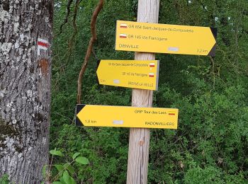
• Départ depuis l'espace de jeu, regagner la digue jusque Radonviller que l'on traverse ensuivant un balisage jaune et ...
![Randonnée Marche Montpothier - MONTPOTHIER, LE VILLAGE ET LES ETANGS - Photo](https://media.geolcdn.com/t/350/260/01e0c3a2-8c77-4555-836b-2b52afee3f19.jpg&format=jpg&maxdim=2)
![Marche Marche](https://static1.geolcdn.com/sitytour/trail-icons/101.png)
Km
Marche
![](/images/other/stat-length.png)
![](https://static1.geolcdn.com/siteimages/upload/files/1508320355ic_sort_den_pos_24dp.png)
![](https://static1.geolcdn.com/siteimages/upload/files/1508320355ic_sort_den_neg_24dp.png)
![](https://static1.geolcdn.com/siteimages/upload/files/16400158638029165_repeat_loop_refresh_sync_direction_icon.png)
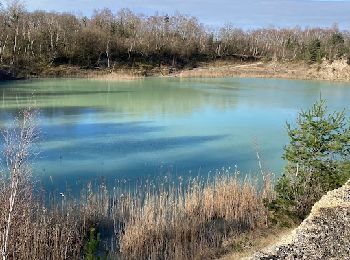
• Au départ de la mairie, on rejoint le site des carrières d'argile anciennement exploitées, situé sur les territoires ...
![Randonnée Marche Ervy-le-Châtel - ERVY LE CHATEL, au départ de la halle - Photo](https://media.geolcdn.com/t/350/260/dcd45609-5197-428b-865e-82e8666405e0.jpg&format=jpg&maxdim=2)
![Marche Marche](https://static1.geolcdn.com/sitytour/trail-icons/101.png)
Km
Marche
![](/images/other/stat-length.png)
![](https://static1.geolcdn.com/siteimages/upload/files/1508320355ic_sort_den_pos_24dp.png)
![](https://static1.geolcdn.com/siteimages/upload/files/1508320355ic_sort_den_neg_24dp.png)
![](https://static1.geolcdn.com/siteimages/upload/files/16400158638029165_repeat_loop_refresh_sync_direction_icon.png)
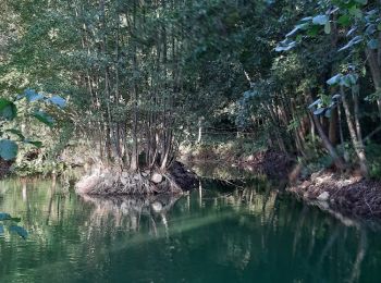
• très belle randonnée, variée ; une traversée ombragée dans le Bois du Parc, on longe plusieurs rus et on avance le lo...
![Randonnée A pied Ferreux-Quincey - FERREUX-QUINCEY à Saint-AUBIN - Photo](https://media.geolcdn.com/t/350/260/0c70cef2-fd4a-4143-9d67-6d8a2bb34e58.jpg&format=jpg&maxdim=2)
![A pied A pied](https://static1.geolcdn.com/sitytour/trail-icons/100.png)
Km
A pied
![](/images/other/stat-length.png)
![](https://static1.geolcdn.com/siteimages/upload/files/1508320355ic_sort_den_pos_24dp.png)
![](https://static1.geolcdn.com/siteimages/upload/files/1508320355ic_sort_den_neg_24dp.png)
![](https://static1.geolcdn.com/siteimages/upload/files/16400158638029165_repeat_loop_refresh_sync_direction_icon.png)
• belle rando de part et d'autre des rives de l'Ardusson ; on passe devant l'imposante abbaye du Paraclet, où le souven...
![Randonnée Marche Prugny - Montbernange - Photo](https://media.geolcdn.com/t/350/260/4b4d4fb7-91b5-4cd4-a11d-924324bd5236.jpg&format=jpg&maxdim=2)
![Marche Marche](https://static1.geolcdn.com/sitytour/trail-icons/101.png)
Km
Marche
![](/images/other/stat-length.png)
![](https://static1.geolcdn.com/siteimages/upload/files/1508320355ic_sort_den_pos_24dp.png)
![](https://static1.geolcdn.com/siteimages/upload/files/1508320355ic_sort_den_neg_24dp.png)
![](https://static1.geolcdn.com/siteimages/upload/files/16400158638029165_repeat_loop_refresh_sync_direction_icon.png)
• Balade , bonnes grimpettes
![Randonnée Marche Chennegy - Le chemin du patrimoine du Valdreux - Photo](https://media.geolcdn.com/t/350/260/ext.jpg?maxdim=2&url=https%3A%2F%2Fservices.sitytrail.com%2FGeolivesWS%2FDownloadMedia.ashx%3FTrailID%3D487691%26Media%3Dfix__20151031115944.jpg)
![Marche Marche](https://static1.geolcdn.com/sitytour/trail-icons/101.png)
Km
Marche
![](/images/other/stat-length.png)
![](https://static1.geolcdn.com/siteimages/upload/files/1508320355ic_sort_den_pos_24dp.png)
![](https://static1.geolcdn.com/siteimages/upload/files/1508320355ic_sort_den_neg_24dp.png)
![](https://static1.geolcdn.com/siteimages/upload/files/16400158638029165_repeat_loop_refresh_sync_direction_icon.png)
• familial - chemins un peu boueux - temps sec préférable
![Randonnée Marche Coursan-en-Othe - Circuit du Coursannais - Coursan-en-Othe - Photo](https://media.geolcdn.com/t/350/260/ext.jpg?maxdim=2&url=https%3A%2F%2Fservices.sitytrail.com%2FGeolivesWS%2FDownloadMedia.ashx%3FTrailID%3D111599%26Media%3D7727_3.jpg)
![Marche Marche](https://static1.geolcdn.com/sitytour/trail-icons/101.png)
Km
Marche
![](/images/other/stat-length.png)
![](https://static1.geolcdn.com/siteimages/upload/files/1508320355ic_sort_den_pos_24dp.png)
![](https://static1.geolcdn.com/siteimages/upload/files/1508320355ic_sort_den_neg_24dp.png)
![](https://static1.geolcdn.com/siteimages/upload/files/16400158638029165_repeat_loop_refresh_sync_direction_icon.png)
• Circuit proposé par l’Office du Tourisme du Chaourçois en Pays d’Armance. Départ de la place Rambourgt à Coursan-en-O...
![Randonnée Marche Bérulle - Sentier du Fer - Bérulle - Photo](https://media.geolcdn.com/t/350/260/ext.jpg?maxdim=2&url=https%3A%2F%2Fservices.sitytrail.com%2FGeolivesWS%2FDownloadMedia.ashx%3FTrailID%3D111397%26Media%3D7114_4.jpg)
![Marche Marche](https://static1.geolcdn.com/sitytour/trail-icons/101.png)
Km
Marche
![](/images/other/stat-length.png)
![](https://static1.geolcdn.com/siteimages/upload/files/1508320355ic_sort_den_pos_24dp.png)
![](https://static1.geolcdn.com/siteimages/upload/files/1508320355ic_sort_den_neg_24dp.png)
![](https://static1.geolcdn.com/siteimages/upload/files/16400158638029165_repeat_loop_refresh_sync_direction_icon.png)
• Circuit proposé par l’Office de Tourisme du Pays d’Othe. Départ du parking proche de l’église de Bérulle. Retrouvez c...
![Randonnée Marche Saint-Mards-en-Othe - De place en place - Saint Mards en Othe - Photo](https://media.geolcdn.com/t/350/260/ext.jpg?maxdim=2&url=https%3A%2F%2Fservices.sitytrail.com%2FGeolivesWS%2FDownloadMedia.ashx%3FTrailID%3D111322%26Media%3D6998_5.jpg)
![Marche Marche](https://static1.geolcdn.com/sitytour/trail-icons/101.png)
Km
Marche
![](/images/other/stat-length.png)
![](https://static1.geolcdn.com/siteimages/upload/files/1508320355ic_sort_den_pos_24dp.png)
![](https://static1.geolcdn.com/siteimages/upload/files/1508320355ic_sort_den_neg_24dp.png)
![](https://static1.geolcdn.com/siteimages/upload/files/16400158638029165_repeat_loop_refresh_sync_direction_icon.png)
• Circuit proposé par l’Office de Tourisme du Pays d’Othe. Départ de la place de la mairie de Saint Mards en Othe. Retr...
![Marche Marche](https://static1.geolcdn.com/sitytour/trail-icons/101.png)
Km
Marche
![](/images/other/stat-length.png)
![](https://static1.geolcdn.com/siteimages/upload/files/1508320355ic_sort_den_pos_24dp.png)
![](https://static1.geolcdn.com/siteimages/upload/files/1508320355ic_sort_den_neg_24dp.png)
![](https://static1.geolcdn.com/siteimages/upload/files/16400158638029165_repeat_loop_refresh_sync_direction_icon.png)
• dosches
![Randonnée Marche Saint-Léger-près-Troyes - La Marche des Hérissons - Photo](https://media.geolcdn.com/t/350/260/ext.jpg?maxdim=2&url=https%3A%2F%2Fservices.sitytrail.com%2FGeolivesWS%2FDownloadMedia.ashx%3FTrailID%3D450067%26Media%3Dfix__20150719155332.jpg)
![Marche Marche](https://static1.geolcdn.com/sitytour/trail-icons/101.png)
Km
Marche
![](/images/other/stat-length.png)
![](https://static1.geolcdn.com/siteimages/upload/files/1508320355ic_sort_den_pos_24dp.png)
![](https://static1.geolcdn.com/siteimages/upload/files/1508320355ic_sort_den_neg_24dp.png)
![](https://static1.geolcdn.com/siteimages/upload/files/16400158638029165_repeat_loop_refresh_sync_direction_icon.png)
• Itinéraire de promenade et de randonnée élaboré par l'école élémentaire de Saint-Léger-près-Troyes
![Randonnée Marche Dienville - Le Balcon du Lac d'Amance - Photo](https://media.geolcdn.com/t/350/260/ext.jpg?maxdim=2&url=https%3A%2F%2Fservices.sitytrail.com%2FGeolivesWS%2FDownloadMedia.ashx%3FTrailID%3D109386%26Media%3D3713_1.jpg)
![Marche Marche](https://static1.geolcdn.com/sitytour/trail-icons/101.png)
Km
Marche
![](/images/other/stat-length.png)
![](https://static1.geolcdn.com/siteimages/upload/files/1508320355ic_sort_den_pos_24dp.png)
![](https://static1.geolcdn.com/siteimages/upload/files/1508320355ic_sort_den_neg_24dp.png)
![](https://static1.geolcdn.com/siteimages/upload/files/16400158638029165_repeat_loop_refresh_sync_direction_icon.png)
• Les Randonnées Thématiques du Comité Régional du Tourisme de Champagne-Ardenne Le Balcon du Lac d'Amance Ce circuit v...
![Randonnée Vélo de route Auxon - EXT80 Auxon-01 - Photo](https://media.geolcdn.com/t/350/260/e8b8adbe-8381-4fb3-b914-73c146b3c4b6.jpg&format=jpg&maxdim=2)
![Vélo de route Vélo de route](https://static1.geolcdn.com/sitytour/trail-icons/201.png)
Km
Vélo de route
![](/images/other/stat-length.png)
![](https://static1.geolcdn.com/siteimages/upload/files/1508320355ic_sort_den_pos_24dp.png)
![](https://static1.geolcdn.com/siteimages/upload/files/1508320355ic_sort_den_neg_24dp.png)
![](https://static1.geolcdn.com/siteimages/upload/files/16400158638029165_repeat_loop_refresh_sync_direction_icon.png)
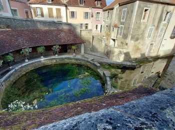
• Dénivelée réelle : 735 m Viste de la Fosse Dionne
![Randonnée Marche Ville-sous-la-Ferté - Clairvaux 14 km - Photo](https://media.geolcdn.com/t/350/260/6d9e3b2b-6262-4a7b-9927-94fb0b6df06e.jpg&format=jpg&maxdim=2)
![Marche Marche](https://static1.geolcdn.com/sitytour/trail-icons/101.png)
Km
Marche
![](/images/other/stat-length.png)
![](https://static1.geolcdn.com/siteimages/upload/files/1508320355ic_sort_den_pos_24dp.png)
![](https://static1.geolcdn.com/siteimages/upload/files/1508320355ic_sort_den_neg_24dp.png)
![](https://static1.geolcdn.com/siteimages/upload/files/16400158638029165_repeat_loop_refresh_sync_direction_icon.png)
• Tour a départ de l’abbaye de Clairvaux, dans les bois environnant, en terminant par la vallée de l’Aube. Elle passe p...
![Randonnée Marche Bouilly - Bouilly le 30.07.22 (9.6kms) N° 2 - Photo](https://media.geolcdn.com/t/350/260/ext.jpg?maxdim=2&url=https%3A%2F%2Fstatic1.geolcdn.com%2Fsiteimages%2Fupload%2Ffiles%2F1553511878bg_sport_marche.png)
![Marche Marche](https://static1.geolcdn.com/sitytour/trail-icons/101.png)
Km
Marche
![](/images/other/stat-length.png)
![](https://static1.geolcdn.com/siteimages/upload/files/1508320355ic_sort_den_pos_24dp.png)
![](https://static1.geolcdn.com/siteimages/upload/files/1508320355ic_sort_den_neg_24dp.png)
![](https://static1.geolcdn.com/siteimages/upload/files/16400158638029165_repeat_loop_refresh_sync_direction_icon.png)
• Facile
![Randonnée Vélo de route Nogent-sur-Seine - EXT65 Nogent sur Seine-02 - Photo](https://media.geolcdn.com/t/350/260/ca417b70-cfc7-449d-acaf-f03a858412c8.jpg&format=jpg&maxdim=2)
![Vélo de route Vélo de route](https://static1.geolcdn.com/sitytour/trail-icons/201.png)
Km
Vélo de route
![](/images/other/stat-length.png)
![](https://static1.geolcdn.com/siteimages/upload/files/1508320355ic_sort_den_pos_24dp.png)
![](https://static1.geolcdn.com/siteimages/upload/files/1508320355ic_sort_den_neg_24dp.png)
![](https://static1.geolcdn.com/siteimages/upload/files/16400158638029165_repeat_loop_refresh_sync_direction_icon.png)
• Eviter passage à Marnay sur Seine en fin de parcours car obligation d'emprunter la D619 à fort trafic de poids lourds...
![Randonnée Vélo de route Nogent-sur-Seine - EXT65 Nogent sur Seine-01 - Photo](https://media.geolcdn.com/t/350/260/f12c7822-7616-49c7-aa13-046d75c5f2da.jpg&format=jpg&maxdim=2)
![Vélo de route Vélo de route](https://static1.geolcdn.com/sitytour/trail-icons/201.png)
Km
Vélo de route
![](/images/other/stat-length.png)
![](https://static1.geolcdn.com/siteimages/upload/files/1508320355ic_sort_den_pos_24dp.png)
![](https://static1.geolcdn.com/siteimages/upload/files/1508320355ic_sort_den_neg_24dp.png)
![](https://static1.geolcdn.com/siteimages/upload/files/16400158638029165_repeat_loop_refresh_sync_direction_icon.png)
• Le passage par Marnay oblige d'emprunter la D619 à fort trafic de poids lourds. Préférer un itinéraire n'empruntant ...
![Randonnée Marche Celles-sur-Ource - randonnée chemin du vigneron à Celles sur Ource - Photo](https://media.geolcdn.com/t/350/260/ext.jpg?maxdim=2&url=https%3A%2F%2Fstatic1.geolcdn.com%2Fsiteimages%2Fupload%2Ffiles%2F1553511878bg_sport_marche.png)
![Marche Marche](https://static1.geolcdn.com/sitytour/trail-icons/101.png)
Km
Marche
![](/images/other/stat-length.png)
![](https://static1.geolcdn.com/siteimages/upload/files/1508320355ic_sort_den_pos_24dp.png)
![](https://static1.geolcdn.com/siteimages/upload/files/1508320355ic_sort_den_neg_24dp.png)
![](https://static1.geolcdn.com/siteimages/upload/files/16400158638029165_repeat_loop_refresh_sync_direction_icon.png)
• Rendonnée du vigneron
![Randonnée Marche Souligny - Souligny 16km le 11/06/2019 - Photo](https://media.geolcdn.com/t/350/260/cb96a311-1155-457a-b30c-92f04f614db0.jpg&format=jpg&maxdim=2)
![Marche Marche](https://static1.geolcdn.com/sitytour/trail-icons/101.png)
Km
Marche
![](/images/other/stat-length.png)
![](https://static1.geolcdn.com/siteimages/upload/files/1508320355ic_sort_den_pos_24dp.png)
![](https://static1.geolcdn.com/siteimages/upload/files/1508320355ic_sort_den_neg_24dp.png)
![](https://static1.geolcdn.com/siteimages/upload/files/16400158638029165_repeat_loop_refresh_sync_direction_icon.png)
![Randonnée V.T.T. Bar-sur-Seine - bar s.seine toto et franck 19.11.17 - Photo](https://media.geolcdn.com/t/350/260/ext.jpg?maxdim=2&url=https%3A%2F%2Fstatic1.geolcdn.com%2Fsiteimages%2Fupload%2Ffiles%2F1524743154velo.jpg)
![V.T.T. V.T.T.](https://static1.geolcdn.com/sitytour/trail-icons/202.png)
Km
V.T.T.
![](/images/other/stat-length.png)
![](https://static1.geolcdn.com/siteimages/upload/files/1508320355ic_sort_den_pos_24dp.png)
![](https://static1.geolcdn.com/siteimages/upload/files/1508320355ic_sort_den_neg_24dp.png)
![](https://static1.geolcdn.com/siteimages/upload/files/16400158638029165_repeat_loop_refresh_sync_direction_icon.png)
• sigle très technicien titop
20 randonnées affichées sur 2012
Application GPS de randonnée GRATUITE
Activités
Régions proches
- Aix-Villemaur-Pâlis
- Amance
- Arcis-sur-Aube
- Arconville
- Argançon
- Arrelles
- Arrentières
- Arsonval
- Assenay
- Assencières
- Auxon
- Avant-lès-Marcilly
- Avirey-Lingey
- Bagneux-la-Fosse
- Bailly-le-Franc
- Balnot-la-Grange
- Balnot-sur-Laignes
- Bar-sur-Aube
- Bar-sur-Seine
- Barberey-Saint-Sulpice
- Barbuise
- Baroville
- Bayel
- Bercenay-en-Othe
- Bercenay-le-Hayer
- Bergères
- Bernon
- Bérulle
- Beurey
- Bligny
- Bossancourt
- Bouilly
- Boulages
- Bouranton
- Bourguignons
- Bouy-Luxembourg
- Bragelogne-Beauvoir
- Braux
- Bréviandes
- Brévonnes
- Briel-sur-Barse
- Brienne-la-Vieille
- Brienne-le-Château
- Brillecourt
- Bucey-en-Othe
- Buchères
- Buxeuil
- Buxières-sur-Arce
- Celles-sur-Ource
- Chacenay
- Chalette-sur-Voire
- Chamoy
- Champ-sur-Barse
- Champfleury
- Champignol-lez-Mondeville
- Channes
- Chaource
- Chapelle-Vallon
- Chappes
- Charmont-sous-Barbuise
- Chaserey
- Châtres
- Chauchigny
- Chaudrey
- Chauffour-lès-Bailly
- Chavanges
- Chennegy
- Chervey
- Chesley
- Chessy-les-Prés
- Clérey
- Coclois
- Colombé-la-Fosse
- Colombé-le-Sec
- Cormost
- Courcelles-sur-Voire
- Courceroy
- Coursan-en-Othe
- Courtaoult
- Courtenot
- Courteranges
- Courteron
- Coussegrey
- Couvignon
- Crancey
- Creney-près-Troyes
- Crésantignes
- Cunfin
- Cussangy
- Davrey
- Dienville
- Dierrey-Saint-Julien
- Dierrey-Saint-Pierre
- Dolancourt
- Dosches
- Dosnon
- Droupt-Saint-Basle
- Droupt-Sainte-Marie
- Eaux-Puiseaux
- Éclance
- Éguilly-sous-Bois
- Engente
- Épagne
- Ervy-le-Châtel
- Essoyes
- Estissac
- Étourvy
- Étrelles-sur-Aube
- Faux-Villecerf
- Fays-la-Chapelle
- Ferreux-Quincey
- Feuges
- Fontaine
- Fontaine-Mâcon
- Fontaine-les-Grès
- Fontette
- Fontvannes
- Fouchères
- Fralignes
- Fravaux
- Fresnoy-le-Château
- Gélannes
- Géraudot
- Gumery
- Gyé-sur-Seine
- Isle-Aumont
- Jaucourt
- Javernant
- Jessains
- Jeugny
- Joncreuil
- Jully-sur-Sarce
- Juvancourt
- La Chaise
- La Chapelle-Saint-Luc
- La Fosse-Corduan
- La Loge-aux-Chèvres
- La Louptière-Thénard
- La Motte-Tilly
- La Rivière-de-Corps
- La Rothière
- La Saulsotte
- La Vendue-Mignot
- La Ville-aux-Bois
- La Villeneuve-au-Châtelot
- La Villeneuve-au-Chêne
- Lagesse
- Laines-aux-Bois
- Landreville
- Lantages
- Laubressel
- Lavau
- Le Mériot
- Le Pavillon-Sainte-Julie
- Lentilles
- Les Bordes-Aumont
- Les Croûtes
- Les Granges
- Les Loges-Margueron
- Les Riceys
- Lesmont
- Lévigny
- Lhuître
- Lignières
- Lirey
- Loches-sur-Ource
- Longchamp-sur-Aujon
- Longpré-le-Sec
- Longsols
- Longueville-sur-Aube
- Lusigny-sur-Barse
- Luyères
- Macey
- Magnant
- Magnicourt
- Mailly-le-Camp
- Maison-des-Champs
- Maisons-lès-Chaource
- Maizières-la-Grande-Paroisse
- Maraye-en-Othe
- Marcilly-le-Hayer
- Marigny-le-Châtel
- Marnay-sur-Seine
- Marolles-lès-Bailly
- Marolles-sous-Lignières
- Mathaux
- Maupas
- Mergey
- Merrey-sur-Arce
- Méry-sur-Seine
- Mesgrigny
- Mesnil-Saint-Loup
- Mesnil-Saint-Père
- Mesnil-Sellières
- Messon
- Metz-Robert
- Meurville
- Montaulin
- Montceaux-lès-Vaudes
- Montfey
- Montgueux
- Montiéramey
- Montigny-les-Monts
- Montmorency-Beaufort
- Montpothier
- Montreuil-sur-Barse
- Montsuzain
- Morembert
- Moussey
- Mussy-sur-Seine
- Neuville-sur-Seine
- Neuville-sur-Vanne
- Noé-les-Mallets
- Nogent-en-Othe
- Nogent-sur-Aube
- Nogent-sur-Seine
- Onjon
- Origny-le-Sec
- Ortillon
- Orvilliers-Saint-Julien
- Ossey-les-Trois-Maisons
- Paisy-Cosdon
- Pars-lès-Romilly
- Payns
- Périgny-la-Rose
- Perthes-lès-Brienne
- Piney
- Plaines-Saint-Lange
- Plancy-l'Abbaye
- Planty
- Plessis-Barbuise
- Poivres
- Poligny
- Polisot
- Polisy
- Pont-Sainte-Marie
- Pont-sur-Seine
- Pouan-les-Vallées
- Pougy
- Pouy-sur-Vannes
- Praslin
- Précy-Saint-Martin
- Proverville
- Prugny
- Prunay-Belleville
- Prusy
- Puits-et-Nuisement
- Racines
- Radonvilliers
- Ramerupt
- Rigny-la-Nonneuse
- Rigny-le-Ferron
- Rilly-Sainte-Syre
- Romilly-sur-Seine
- Roncenay
- Rosières-près-Troyes
- Rosnay-l'Hôpital
- Rouilly-Sacey
- Rouilly-Saint-Loup
- Rouvres-les-Vignes
- Rumilly-lès-Vaudes
- Ruvigny
- Saint-André-les-Vergers
- Saint-Aubin
- Saint-Benoist-sur-Vanne
- Saint-Benoît-sur-Seine
- Saint-Christophe-Dodinicourt
- Saint-Étienne-sous-Barbuise
- Saint-Flavy
- Saint-Germain
- Saint-Hilaire-sous-Romilly
- Saint-Jean-de-Bonneval
- Saint-Julien-les-Villas
- Saint-Léger-près-Troyes
- Saint-Léger-sous-Brienne
- Saint-Léger-sous-Margerie
- Saint-Loup-de-Buffigny
- Saint-Lupien
- Saint-Lyé
- Saint-Mards-en-Othe
- Saint-Martin-de-Bossenay
- Saint-Mesmin
- Saint-Nicolas-la-Chapelle
- Saint-Oulph
- Saint-Parres-aux-Tertres
- Saint-Parres-lès-Vaudes
- Saint-Phal
- Saint-Pouange
- Saint-Thibault
- Saint-Usage
- Sainte-Maure
- Sainte-Savine
- Savières
- Sommeval
- Soulaines-Dhuys
- Souligny
- Spoy
- Thennelières
- Thieffrain
- Torcy-le-Petit
- Torvilliers
- Traînel
- Trancault
- Troyes
- Unienville
- Vailly
- Val-d'Auzon
- Vallant-Saint-Georges
- Vallières
- Vanlay
- Vauchassis
- Vauchonvilliers
- Vaudes
- Vaupoisson
- Vendeuvre-sur-Barse
- Verpillières-sur-Ource
- Verrières
- Viâpres-le-Petit
- Villacerf
- Villadin
- Ville-sous-la-Ferté
- Ville-sur-Arce
- Villechétif
- Villeloup
- Villemereuil
- Villemoiron-en-Othe
- Villemorien
- Villemoyenne
- Villenauxe-la-Grande
- Villeneuve-au-Chemin
- Villeret
- Villery
- Villette-sur-Aube
- Villiers-le-Bois
- Villy-en-Trodes
- Villy-le-Maréchal
- Virey-sous-Bar
- Vitry-le-Croisé
- Voigny
- Vosnon
- Voué
- Vougrey
- Vulaines