![](/images/other/stat-length.png)
- Randonnées
- Outdoor
- France
- Auvergne-Rhône-Alpes
- Savoie
- Pralognan-la-Vanoise
Pralognan-la-Vanoise, Savoie : Les meilleures randonnées, itinéraires, parcours, balades et promenades
Pralognan-la-Vanoise : découvrez les meilleures randonnées : 505 pédestres, 8 à vélo ou VTT et 2 parcours équestres. Tous ces circuits, parcours, itinéraires et activités en plein air sont disponibles dans nos applications SityTrail pour smartphones et tablettes.
Les meilleurs parcours (625)
![Randonnée Marche Pralognan-la-Vanoise - Vanoise 2021 : refuge de la Vanoise au refuge de la Valette par les glacier et le dôme des Sonnailles (-07-18).ori - Photo](https://media.geolcdn.com/t/350/260/aa7290a4-f49c-4ba3-9cdb-5f8383ee7015.jpg&format=jpg&maxdim=2)
![Marche Marche](https://static1.geolcdn.com/sitytour/trail-icons/101.png)
Km
Marche
![](/images/other/stat-length.png)
![](https://static1.geolcdn.com/siteimages/upload/files/1508320355ic_sort_den_pos_24dp.png)
![](https://static1.geolcdn.com/siteimages/upload/files/1508320355ic_sort_den_neg_24dp.png)
![](https://static1.geolcdn.com/siteimages/upload/files/16400158638029165_repeat_loop_refresh_sync_direction_icon.png)
![Randonnée Marche Pralognan-la-Vanoise - Pralognan - Les Prioux Lac de Chalet Clou - Photo](https://media.geolcdn.com/t/350/260/aef0b6ed-57e6-4d04-a75d-d2ffe6e61cd4.jpg&format=jpg&maxdim=2)
![Marche Marche](https://static1.geolcdn.com/sitytour/trail-icons/101.png)
Km
Marche
![](/images/other/stat-length.png)
![](https://static1.geolcdn.com/siteimages/upload/files/1508320355ic_sort_den_pos_24dp.png)
![](https://static1.geolcdn.com/siteimages/upload/files/1508320355ic_sort_den_neg_24dp.png)
![](https://static1.geolcdn.com/siteimages/upload/files/16400158638029165_repeat_loop_refresh_sync_direction_icon.png)
![Randonnée Marche Pralognan-la-Vanoise - Pralognan - la crête du mont Charvet - Photo](https://media.geolcdn.com/t/350/260/54cee105-6456-408f-be19-9af4b98c1ac1.jpg&format=jpg&maxdim=2)
![Marche Marche](https://static1.geolcdn.com/sitytour/trail-icons/101.png)
Km
Marche
![](/images/other/stat-length.png)
![](https://static1.geolcdn.com/siteimages/upload/files/1508320355ic_sort_den_pos_24dp.png)
![](https://static1.geolcdn.com/siteimages/upload/files/1508320355ic_sort_den_neg_24dp.png)
![](https://static1.geolcdn.com/siteimages/upload/files/16400158638029165_repeat_loop_refresh_sync_direction_icon.png)
![Randonnée Marche Pralognan-la-Vanoise - pointe de Leschaux - Photo](https://media.geolcdn.com/t/350/260/c0179711-7974-4489-9ffb-171084fcf8a1.jpg&format=jpg&maxdim=2)
![Marche Marche](https://static1.geolcdn.com/sitytour/trail-icons/101.png)
Km
Marche
![](/images/other/stat-length.png)
![](https://static1.geolcdn.com/siteimages/upload/files/1508320355ic_sort_den_pos_24dp.png)
![](https://static1.geolcdn.com/siteimages/upload/files/1508320355ic_sort_den_neg_24dp.png)
![](https://static1.geolcdn.com/siteimages/upload/files/16400158638029165_repeat_loop_refresh_sync_direction_icon.png)
• rando effectuée le 14 juillet 2023 une des plus belles de Pralognan attention un passage avec câble entre le col et l...
![Randonnée Marche Pralognan-la-Vanoise - Dôme de Polset - Photo](https://media.geolcdn.com/t/350/260/d8728bcc-8f02-4bb7-b487-a9a7b63957df.jpg&format=jpg&maxdim=2)
![Marche Marche](https://static1.geolcdn.com/sitytour/trail-icons/101.png)
Km
Marche
![](/images/other/stat-length.png)
![](https://static1.geolcdn.com/siteimages/upload/files/1508320355ic_sort_den_pos_24dp.png)
![](https://static1.geolcdn.com/siteimages/upload/files/1508320355ic_sort_den_neg_24dp.png)
![](https://static1.geolcdn.com/siteimages/upload/files/16400158638029165_repeat_loop_refresh_sync_direction_icon.png)
• lundi 10 juillet 2023 attention il s'agit d'une course d'alpinisme qui bien que classée facile nécessite des compéten...
![Randonnée Marche Pralognan-la-Vanoise - traversée des Fontanettes aux Prioux par le col du Grand marchet - Photo](https://media.geolcdn.com/t/350/260/24a33514-db38-4400-a38f-98ffcbd53fe7.jpg&format=jpg&maxdim=2)
![Marche Marche](https://static1.geolcdn.com/sitytour/trail-icons/101.png)
Km
Marche
![](/images/other/stat-length.png)
![](https://static1.geolcdn.com/siteimages/upload/files/1508320355ic_sort_den_pos_24dp.png)
![](https://static1.geolcdn.com/siteimages/upload/files/1508320355ic_sort_den_neg_24dp.png)
![](https://static1.geolcdn.com/siteimages/upload/files/16400158638029165_repeat_loop_refresh_sync_direction_icon.png)
• randonnée effectuée le 6 juillet 2023 attention la montée au col du Grand marchet comporte quelques passages rocheux ...
![Randonnée Marche Pralognan-la-Vanoise - le lac de la patinoire - Photo](https://media.geolcdn.com/t/350/260/88bae2e9-35f9-4ca5-a526-616594e07db8.jpg&format=jpg&maxdim=2)
![Marche Marche](https://static1.geolcdn.com/sitytour/trail-icons/101.png)
Km
Marche
![](/images/other/stat-length.png)
![](https://static1.geolcdn.com/siteimages/upload/files/1508320355ic_sort_den_pos_24dp.png)
![](https://static1.geolcdn.com/siteimages/upload/files/1508320355ic_sort_den_neg_24dp.png)
![](https://static1.geolcdn.com/siteimages/upload/files/16400158638029165_repeat_loop_refresh_sync_direction_icon.png)
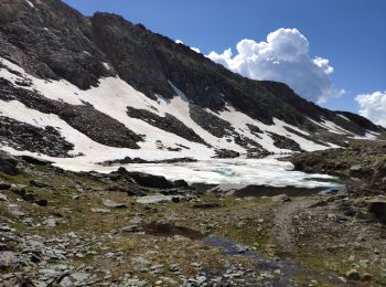
• rando effectuée le 3 juillet 2023 attention en début de saison la présence de névés à la descente du col Rosset peut...
![Randonnée Marche Pralognan-la-Vanoise - col de napremont - Photo](https://media.geolcdn.com/t/350/260/6fea95cc-6da2-44f1-9ef9-b36a9d856ac2.jpg&format=jpg&maxdim=2)
![Marche Marche](https://static1.geolcdn.com/sitytour/trail-icons/101.png)
Km
Marche
![](/images/other/stat-length.png)
![](https://static1.geolcdn.com/siteimages/upload/files/1508320355ic_sort_den_pos_24dp.png)
![](https://static1.geolcdn.com/siteimages/upload/files/1508320355ic_sort_den_neg_24dp.png)
![](https://static1.geolcdn.com/siteimages/upload/files/16400158638029165_repeat_loop_refresh_sync_direction_icon.png)
• randonnée effectuée le 2 juillet 2023 pour ceux qui sont sensibles au vertiges privilégiez le sens inverse de la rand...
![Randonnée Marche Pralognan-la-Vanoise - 2022-06-28 Marche TGV Refuge Valette Pralognan - Photo](https://media.geolcdn.com/t/350/260/64cb2300-ba57-4fac-bb37-92f95e3da956.jpg&format=jpg&maxdim=2)
![Marche Marche](https://static1.geolcdn.com/sitytour/trail-icons/101.png)
Km
Marche
![](/images/other/stat-length.png)
![](https://static1.geolcdn.com/siteimages/upload/files/1508320355ic_sort_den_pos_24dp.png)
![](https://static1.geolcdn.com/siteimages/upload/files/1508320355ic_sort_den_neg_24dp.png)
![](https://static1.geolcdn.com/siteimages/upload/files/16400158638029165_repeat_loop_refresh_sync_direction_icon.png)
• - Etape 05 - Refuge de la Valette - Pralognan Les Fontanettes
![Randonnée Marche Pralognan-la-Vanoise - 2022-06-25 Marche TGV Refuge Col de la Vanoise Refuge Arpont - Photo](https://media.geolcdn.com/t/350/260/587664c3-adc0-4274-b3bf-f23cbb6ff639.jpg&format=jpg&maxdim=2)
![Marche Marche](https://static1.geolcdn.com/sitytour/trail-icons/101.png)
Km
Marche
![](/images/other/stat-length.png)
![](https://static1.geolcdn.com/siteimages/upload/files/1508320355ic_sort_den_pos_24dp.png)
![](https://static1.geolcdn.com/siteimages/upload/files/1508320355ic_sort_den_neg_24dp.png)
![](https://static1.geolcdn.com/siteimages/upload/files/16400158638029165_repeat_loop_refresh_sync_direction_icon.png)
• Etape 02 - Refuge Col de la Vanoise - Refuge de l'Arpont
![Randonnée Marche Pralognan-la-Vanoise - 2022-06-24 Marche TGV Pralognan Refuge du Col de la Vanoise - Photo](https://media.geolcdn.com/t/350/260/c4f04535-b0e5-45fd-a513-c3cb8f626a13.jpg&format=jpg&maxdim=2)
![Marche Marche](https://static1.geolcdn.com/sitytour/trail-icons/101.png)
Km
Marche
![](/images/other/stat-length.png)
![](https://static1.geolcdn.com/siteimages/upload/files/1508320355ic_sort_den_pos_24dp.png)
![](https://static1.geolcdn.com/siteimages/upload/files/1508320355ic_sort_den_neg_24dp.png)
![](https://static1.geolcdn.com/siteimages/upload/files/16400158638029165_repeat_loop_refresh_sync_direction_icon.png)
• Etape 01 - Marche de Pralognan Les Fontanettes - Refuge Col de la Vanoise
![Randonnée Marche Pralognan-la-Vanoise - col d'Aussois et pointe de l'Observatoire - Photo](https://media.geolcdn.com/t/350/260/2fde2aa0-abdb-4870-bdd9-82be854bfe3a.jpg&format=jpg&maxdim=2)
![Marche Marche](https://static1.geolcdn.com/sitytour/trail-icons/101.png)
Km
Marche
![](/images/other/stat-length.png)
![](https://static1.geolcdn.com/siteimages/upload/files/1508320355ic_sort_den_pos_24dp.png)
![](https://static1.geolcdn.com/siteimages/upload/files/1508320355ic_sort_den_neg_24dp.png)
![](https://static1.geolcdn.com/siteimages/upload/files/16400158638029165_repeat_loop_refresh_sync_direction_icon.png)
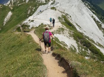
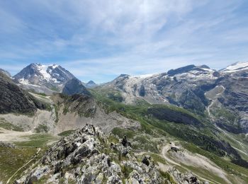
• Un magnifique belvédère du massif du Mont Blanc à celui des écrins lorsque le temps est dégagé. Attention il s'agit d...
![Randonnée Marche Pralognan-la-Vanoise - le refuge de La Valette (traversée) - Photo](https://media.geolcdn.com/t/350/260/426a5370-8a9e-4055-9485-926570ebee7e.jpg&format=jpg&maxdim=2)
![Marche Marche](https://static1.geolcdn.com/sitytour/trail-icons/101.png)
Km
Marche
![](/images/other/stat-length.png)
![](https://static1.geolcdn.com/siteimages/upload/files/1508320355ic_sort_den_pos_24dp.png)
![](https://static1.geolcdn.com/siteimages/upload/files/1508320355ic_sort_den_neg_24dp.png)
![](https://static1.geolcdn.com/siteimages/upload/files/16400158638029165_repeat_loop_refresh_sync_direction_icon.png)
• La montée à partir des Prioux ne pose aucun problème. En revanche, la descente (1350 m de dénivelée) par s'effectue p...
![Randonnée Marche Pralognan-la-Vanoise - Le Petit Mont Blanc - Photo](https://media.geolcdn.com/t/350/260/d378fa37-388b-4a67-b4ab-b59e87915009.jpg&format=jpg&maxdim=2)
![Marche Marche](https://static1.geolcdn.com/sitytour/trail-icons/101.png)
Km
Marche
![](/images/other/stat-length.png)
![](https://static1.geolcdn.com/siteimages/upload/files/1508320355ic_sort_den_pos_24dp.png)
![](https://static1.geolcdn.com/siteimages/upload/files/1508320355ic_sort_den_neg_24dp.png)
![](https://static1.geolcdn.com/siteimages/upload/files/16400158638029165_repeat_loop_refresh_sync_direction_icon.png)
• La montée s'effectue par l'itinéraire des 100 virages. Il s'agit d'un itinéraire un peu plus scabreux à déconseiller ...
![Randonnée Marche Pralognan-la-Vanoise - le petit mont blanc par le Grand bechu - Photo](https://media.geolcdn.com/t/350/260/a3fbbae2-00f6-4347-9789-00a273125012.jpg&format=jpg&maxdim=2)
![Marche Marche](https://static1.geolcdn.com/sitytour/trail-icons/101.png)
Km
Marche
![](/images/other/stat-length.png)
![](https://static1.geolcdn.com/siteimages/upload/files/1508320355ic_sort_den_pos_24dp.png)
![](https://static1.geolcdn.com/siteimages/upload/files/1508320355ic_sort_den_neg_24dp.png)
![](https://static1.geolcdn.com/siteimages/upload/files/16400158638029165_repeat_loop_refresh_sync_direction_icon.png)
• aérien mais sans plus. Très beau panorama.
![Randonnée Marche Pralognan-la-Vanoise - Pralognan - Petit Mont Blanc 2677m 08/07/2019 - Photo](https://media.geolcdn.com/t/350/260/ext.jpg?maxdim=2&url=https%3A%2F%2Fstatic1.geolcdn.com%2Fsiteimages%2Fupload%2Ffiles%2F1553511878bg_sport_marche.png)
![Marche Marche](https://static1.geolcdn.com/sitytour/trail-icons/101.png)
Km
Marche
![](/images/other/stat-length.png)
![](https://static1.geolcdn.com/siteimages/upload/files/1508320355ic_sort_den_pos_24dp.png)
![](https://static1.geolcdn.com/siteimages/upload/files/1508320355ic_sort_den_neg_24dp.png)
![](https://static1.geolcdn.com/siteimages/upload/files/16400158638029165_repeat_loop_refresh_sync_direction_icon.png)
![Randonnée Marche Pralognan-la-Vanoise - Col de la Vanoise - Photo](https://media.geolcdn.com/t/350/260/ext.jpg?maxdim=2&url=https%3A%2F%2Fstatic1.geolcdn.com%2Fsiteimages%2Fupload%2Ffiles%2F1553511878bg_sport_marche.png)
![Marche Marche](https://static1.geolcdn.com/sitytour/trail-icons/101.png)
Km
Marche
![](/images/other/stat-length.png)
![](https://static1.geolcdn.com/siteimages/upload/files/1508320355ic_sort_den_pos_24dp.png)
![](https://static1.geolcdn.com/siteimages/upload/files/1508320355ic_sort_den_neg_24dp.png)
![](https://static1.geolcdn.com/siteimages/upload/files/16400158638029165_repeat_loop_refresh_sync_direction_icon.png)
• Col de la Vanoise : TS du génépi entre les Fontanettes et le refuge des Barmettes. Puis passage par le lac des Vaches...
![Randonnée Marche Pralognan-la-Vanoise - J2:Refuge de Péclet Polset et le lac Blanc . - Photo](https://media.geolcdn.com/t/350/260/ext.jpg?maxdim=2&url=https%3A%2F%2Fstatic1.geolcdn.com%2Fsiteimages%2Fupload%2Ffiles%2F1553511878bg_sport_marche.png)
![Marche Marche](https://static1.geolcdn.com/sitytour/trail-icons/101.png)
Km
Marche
![](/images/other/stat-length.png)
![](https://static1.geolcdn.com/siteimages/upload/files/1508320355ic_sort_den_pos_24dp.png)
![](https://static1.geolcdn.com/siteimages/upload/files/1508320355ic_sort_den_neg_24dp.png)
![](https://static1.geolcdn.com/siteimages/upload/files/16400158638029165_repeat_loop_refresh_sync_direction_icon.png)
• J2:Refuge de Péclet Polset et le lac Blanc .
![Randonnée Marche Pralognan-la-Vanoise - tour pic de la vanoise - Photo](https://media.geolcdn.com/t/350/260/ext.jpg?maxdim=2&url=https%3A%2F%2Fstatic1.geolcdn.com%2Fsiteimages%2Fupload%2Ffiles%2F1553511878bg_sport_marche.png)
![Marche Marche](https://static1.geolcdn.com/sitytour/trail-icons/101.png)
Km
Marche
![](/images/other/stat-length.png)
![](https://static1.geolcdn.com/siteimages/upload/files/1508320355ic_sort_den_pos_24dp.png)
![](https://static1.geolcdn.com/siteimages/upload/files/1508320355ic_sort_den_neg_24dp.png)
![](https://static1.geolcdn.com/siteimages/upload/files/16400158638029165_repeat_loop_refresh_sync_direction_icon.png)
•
![Randonnée Marche Pralognan-la-Vanoise - Crêtres du Mont Charvet - Photo](https://media.geolcdn.com/t/350/260/ext.jpg?maxdim=2&url=https%3A%2F%2Fstatic1.geolcdn.com%2Fsiteimages%2Fupload%2Ffiles%2F1553511878bg_sport_marche.png)
![Marche Marche](https://static1.geolcdn.com/sitytour/trail-icons/101.png)
Km
Marche
![](/images/other/stat-length.png)
![](https://static1.geolcdn.com/siteimages/upload/files/1508320355ic_sort_den_pos_24dp.png)
![](https://static1.geolcdn.com/siteimages/upload/files/1508320355ic_sort_den_neg_24dp.png)
![](https://static1.geolcdn.com/siteimages/upload/files/16400158638029165_repeat_loop_refresh_sync_direction_icon.png)
• Pralognan, col de la grande Pierre, Crêtres du Mont Charvet, retour sur la Croix puis Pralognan
20 randonnées affichées sur 625
Application GPS de randonnée GRATUITE