


18,9 km | 27 km-effort
Colombier : découvrez les meilleures randonnées : 9 pédestres et 8 parcours équestres. Tous ces circuits, parcours, itinéraires et activités en plein air sont disponibles dans nos applications SityTrail pour smartphones et tablettes.
Marche


• Belle rando a faire par (trés) beau temps car en altitude et boisée Parking sous Chapelle ST Sabin Auberge St Sabin ...
Marche
• reco faite 07/21 passage délicat sur retour dernière partie apres tripet arrivee sur Mantel

Marche
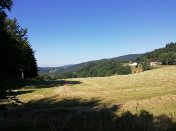
• beau paysage
Marche
• randonnée

Randonnée équestre
• g
Randonnée équestre
• modif

 19.552
sport
• Randonnée à cheval de 20 km (30 km effort dû au dénivelé) passant par la table d'orientation du Crêt de la Perdrix; c...
Randonnée équestre
• Randonnée de 16 km (29 km-effort, 950 m dénivelé +/-) Départ par l'est avant Le Mantel direction le col de l'Etançon;...
Randonnée équestre
• Randonnée à cheval de 20 km (30 km effort dû au dénivelé) passant par la table d'orientation du Crêt de la Perdrix; c...
Randonnée équestre
• Itinéraire du pnr Pilat
Marche
Marche
Randonnée équestre
Marche
Randonnée équestre
Randonnée équestre
Marche

A pied
18 randonnées affichées sur 18
Application GPS de randonnée GRATUITE
 SityTrail
IGN / Instituts géographiques
SityTrail World
Le monde est à vous