![](/images/other/stat-length.png)
- Randonnées
- Outdoor
- Espagne
- Îles Baléares
- Inconnu
Inconnu, Îles Baléares : Les meilleures randonnées, itinéraires, parcours, balades et promenades
Inconnu : découvrez les meilleures randonnées : 202 pédestres et 61 à vélo ou VTT. Tous ces circuits, parcours, itinéraires et activités en plein air sont disponibles dans nos applications SityTrail pour smartphones et tablettes.
Les meilleurs parcours (275)
![Randonnée A pied Puigpunyent - Son Font - Bauca - Galilea - Son Font - Photo](https://media.geolcdn.com/t/350/260/c9bb5d09-3486-4cef-bbf4-0b70d1dd010c.jpeg&format=jpg&maxdim=2)
![A pied A pied](https://static1.geolcdn.com/sitytour/trail-icons/100.png)
Km
A pied
![](/images/other/stat-length.png)
![](https://static1.geolcdn.com/siteimages/upload/files/1508320355ic_sort_den_pos_24dp.png)
![](https://static1.geolcdn.com/siteimages/upload/files/1508320355ic_sort_den_neg_24dp.png)
![](https://static1.geolcdn.com/siteimages/upload/files/16400158638029165_repeat_loop_refresh_sync_direction_icon.png)
• Symbole: schwarzes Dreieck bzw. Steinpyramiden
![Randonnée A pied Banyalbufar - Camí de sa Volta des General - Photo](https://media.geolcdn.com/t/350/260/8b28ca13-a16d-4887-a8d7-ae1af2458aa6.jpeg&format=jpg&maxdim=2)
![A pied A pied](https://static1.geolcdn.com/sitytour/trail-icons/100.png)
Km
A pied
![](/images/other/stat-length.png)
![](https://static1.geolcdn.com/siteimages/upload/files/1508320355ic_sort_den_pos_24dp.png)
![](https://static1.geolcdn.com/siteimages/upload/files/1508320355ic_sort_den_neg_24dp.png)
![](https://static1.geolcdn.com/siteimages/upload/files/16400158638029165_repeat_loop_refresh_sync_direction_icon.png)
• I haven't seen a green circle with black 8 there...!?
![Randonnée Marche Sant Joan de Labritja - Ibiza-Cala en Serra 17-10-2016 - Photo](https://media.geolcdn.com/t/350/260/ext.jpg?maxdim=2&url=https%3A%2F%2Fstatic1.geolcdn.com%2Fsiteimages%2Fupload%2Ffiles%2F1553511878bg_sport_marche.png)
![Marche Marche](https://static1.geolcdn.com/sitytour/trail-icons/101.png)
Km
Marche
![](/images/other/stat-length.png)
![](https://static1.geolcdn.com/siteimages/upload/files/1508320355ic_sort_den_pos_24dp.png)
![](https://static1.geolcdn.com/siteimages/upload/files/1508320355ic_sort_den_neg_24dp.png)
![](https://static1.geolcdn.com/siteimages/upload/files/16400158638029165_repeat_loop_refresh_sync_direction_icon.png)
![Randonnée Marche Sant Joan de Labritja - Ibiza-Portixol 16-10-2016 - Photo](https://media.geolcdn.com/t/350/260/ext.jpg?maxdim=2&url=https%3A%2F%2Fstatic1.geolcdn.com%2Fsiteimages%2Fupload%2Ffiles%2F1553511878bg_sport_marche.png)
![Marche Marche](https://static1.geolcdn.com/sitytour/trail-icons/101.png)
Km
Marche
![](/images/other/stat-length.png)
![](https://static1.geolcdn.com/siteimages/upload/files/1508320355ic_sort_den_pos_24dp.png)
![](https://static1.geolcdn.com/siteimages/upload/files/1508320355ic_sort_den_neg_24dp.png)
![](https://static1.geolcdn.com/siteimages/upload/files/16400158638029165_repeat_loop_refresh_sync_direction_icon.png)
![Randonnée Marche Sant Antoni de Portmany - Ibiza-Santa Agnes 15-10-2016 - Photo](https://media.geolcdn.com/t/350/260/ext.jpg?maxdim=2&url=https%3A%2F%2Fservices.sitytrail.com%2FGeolivesWS%2FDownloadMedia.ashx%3FTrailID%3D656302%26Media%3Dfix__20161015120731.jpg)
![Marche Marche](https://static1.geolcdn.com/sitytour/trail-icons/101.png)
Km
Marche
![](/images/other/stat-length.png)
![](https://static1.geolcdn.com/siteimages/upload/files/1508320355ic_sort_den_pos_24dp.png)
![](https://static1.geolcdn.com/siteimages/upload/files/1508320355ic_sort_den_neg_24dp.png)
![](https://static1.geolcdn.com/siteimages/upload/files/16400158638029165_repeat_loop_refresh_sync_direction_icon.png)
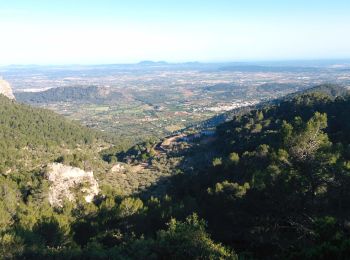
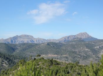
• Pas de vue au sommet, belle vue sur la crête.
![Randonnée Marche Es Mercadal - hggff - Photo](https://media.geolcdn.com/t/350/260/48ed1395-8df2-4943-8b53-da871c3a3a91.jpg&format=jpg&maxdim=2)
![Marche Marche](https://static1.geolcdn.com/sitytour/trail-icons/101.png)
Km
Marche
![](/images/other/stat-length.png)
![](https://static1.geolcdn.com/siteimages/upload/files/1508320355ic_sort_den_pos_24dp.png)
![](https://static1.geolcdn.com/siteimages/upload/files/1508320355ic_sort_den_neg_24dp.png)
![](https://static1.geolcdn.com/siteimages/upload/files/16400158638029165_repeat_loop_refresh_sync_direction_icon.png)
• hgfdd
![Randonnée Marche Citadelle - cala pilar - Photo](https://media.geolcdn.com/t/350/260/f5bd0742-bf3e-4139-829a-701198701216.jpg&format=jpg&maxdim=2)
![Marche Marche](https://static1.geolcdn.com/sitytour/trail-icons/101.png)
Km
Marche
![](/images/other/stat-length.png)
![](https://static1.geolcdn.com/siteimages/upload/files/1508320355ic_sort_den_pos_24dp.png)
![](https://static1.geolcdn.com/siteimages/upload/files/1508320355ic_sort_den_neg_24dp.png)
![](https://static1.geolcdn.com/siteimages/upload/files/16400158638029165_repeat_loop_refresh_sync_direction_icon.png)
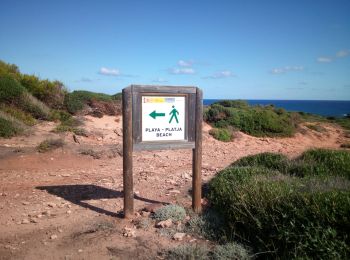
• marche de 35 mn pour la plage depuis parkon
![Randonnée Marche es Migjorn Gran - sant thomas a plage - Photo](https://media.geolcdn.com/t/350/260/399719de-8286-4096-bac7-4163a2144d8c.jpg&format=jpg&maxdim=2)
![Marche Marche](https://static1.geolcdn.com/sitytour/trail-icons/101.png)
Km
Marche
![](/images/other/stat-length.png)
![](https://static1.geolcdn.com/siteimages/upload/files/1508320355ic_sort_den_pos_24dp.png)
![](https://static1.geolcdn.com/siteimages/upload/files/1508320355ic_sort_den_neg_24dp.png)
![](https://static1.geolcdn.com/siteimages/upload/files/16400158638029165_repeat_loop_refresh_sync_direction_icon.png)
• chemin litoral
![Randonnée Marche Escorca - MAJORQUE - Puig de Massanella (Lluc) - Photo](https://media.geolcdn.com/t/350/260/0146494d-2f00-45ad-8bcd-6744d5040fa2.jpg&format=jpg&maxdim=2)
![Marche Marche](https://static1.geolcdn.com/sitytour/trail-icons/101.png)
Km
Marche
![](/images/other/stat-length.png)
![](https://static1.geolcdn.com/siteimages/upload/files/1508320355ic_sort_den_pos_24dp.png)
![](https://static1.geolcdn.com/siteimages/upload/files/1508320355ic_sort_den_neg_24dp.png)
![](https://static1.geolcdn.com/siteimages/upload/files/16400158638029165_repeat_loop_refresh_sync_direction_icon.png)
![Randonnée Marche Escorca - MAJORQUE - Tossals Verds (SOLLER) - Photo](https://media.geolcdn.com/t/350/260/e090f755-ec06-4ebf-82cb-45354860c0e6.jpg&format=jpg&maxdim=2)
![Marche Marche](https://static1.geolcdn.com/sitytour/trail-icons/101.png)
Km
Marche
![](/images/other/stat-length.png)
![](https://static1.geolcdn.com/siteimages/upload/files/1508320355ic_sort_den_pos_24dp.png)
![](https://static1.geolcdn.com/siteimages/upload/files/1508320355ic_sort_den_neg_24dp.png)
![](https://static1.geolcdn.com/siteimages/upload/files/16400158638029165_repeat_loop_refresh_sync_direction_icon.png)
![Randonnée Marche Sóller - MAJORQUE - Gorges de Biniaraix (SOLLER) - Photo](https://media.geolcdn.com/t/350/260/51733406-bf06-4275-a18a-d423756de85c.jpg&format=jpg&maxdim=2)
![Marche Marche](https://static1.geolcdn.com/sitytour/trail-icons/101.png)
Km
Marche
![](/images/other/stat-length.png)
![](https://static1.geolcdn.com/siteimages/upload/files/1508320355ic_sort_den_pos_24dp.png)
![](https://static1.geolcdn.com/siteimages/upload/files/1508320355ic_sort_den_neg_24dp.png)
![](https://static1.geolcdn.com/siteimages/upload/files/16400158638029165_repeat_loop_refresh_sync_direction_icon.png)
![Randonnée A pied sa Pobla - Cami d'Enmig-ses Puntes - Photo](https://media.geolcdn.com/t/350/260/724ebe77-69ac-431d-b9e8-a61613e05468.jpeg&format=jpg&maxdim=2)
![A pied A pied](https://static1.geolcdn.com/sitytour/trail-icons/100.png)
Km
A pied
![](/images/other/stat-length.png)
![](https://static1.geolcdn.com/siteimages/upload/files/1508320355ic_sort_den_pos_24dp.png)
![](https://static1.geolcdn.com/siteimages/upload/files/1508320355ic_sort_den_neg_24dp.png)
![](https://static1.geolcdn.com/siteimages/upload/files/16400158638029165_repeat_loop_refresh_sync_direction_icon.png)
![Randonnée A pied Banyalbufar - Camí des Pescadors - Photo](https://media.geolcdn.com/t/350/260/ede1eb3a-e761-43e6-b1d2-8ff02557f9d3.jpeg&format=jpg&maxdim=2)
![A pied A pied](https://static1.geolcdn.com/sitytour/trail-icons/100.png)
Km
A pied
![](/images/other/stat-length.png)
![](https://static1.geolcdn.com/siteimages/upload/files/1508320355ic_sort_den_pos_24dp.png)
![](https://static1.geolcdn.com/siteimages/upload/files/1508320355ic_sort_den_neg_24dp.png)
![](https://static1.geolcdn.com/siteimages/upload/files/16400158638029165_repeat_loop_refresh_sync_direction_icon.png)
![Randonnée A pied Alaró - ES-14 AC - Photo](https://media.geolcdn.com/t/350/260/b00e83eb-40d8-43b9-a0ec-9b667b6177cb.jpeg&format=jpg&maxdim=2)
![A pied A pied](https://static1.geolcdn.com/sitytour/trail-icons/100.png)
Km
A pied
![](/images/other/stat-length.png)
![](https://static1.geolcdn.com/siteimages/upload/files/1508320355ic_sort_den_pos_24dp.png)
![](https://static1.geolcdn.com/siteimages/upload/files/1508320355ic_sort_den_neg_24dp.png)
![](https://static1.geolcdn.com/siteimages/upload/files/16400158638029165_repeat_loop_refresh_sync_direction_icon.png)
![Randonnée A pied Calvià - ES-02 SE - Photo](https://media.geolcdn.com/t/350/260/ad0827dc-6a02-47d9-941c-ed8ea749e8f3.jpeg&format=jpg&maxdim=2)
![A pied A pied](https://static1.geolcdn.com/sitytour/trail-icons/100.png)
Km
A pied
![](/images/other/stat-length.png)
![](https://static1.geolcdn.com/siteimages/upload/files/1508320355ic_sort_den_pos_24dp.png)
![](https://static1.geolcdn.com/siteimages/upload/files/1508320355ic_sort_den_neg_24dp.png)
![](https://static1.geolcdn.com/siteimages/upload/files/16400158638029165_repeat_loop_refresh_sync_direction_icon.png)
• This has not official name and no official route. The name:de and ref of route are from the book appear in source:name
![Randonnée A pied Calvià - ES-This has not official name. It seems it has german unofficial name. Please, note that the hiking routes have no name if not appear in official sources (Consell de Mallorca, Comunitat Autònoma de les Illes Balears, Townhall publications, etc) - Photo](https://media.geolcdn.com/t/350/260/e790b3da-512c-4682-a0e9-5527d7d0b775.jpeg&format=jpg&maxdim=2)
![A pied A pied](https://static1.geolcdn.com/sitytour/trail-icons/100.png)
Km
A pied
![](/images/other/stat-length.png)
![](https://static1.geolcdn.com/siteimages/upload/files/1508320355ic_sort_den_pos_24dp.png)
![](https://static1.geolcdn.com/siteimages/upload/files/1508320355ic_sort_den_neg_24dp.png)
![](https://static1.geolcdn.com/siteimages/upload/files/16400158638029165_repeat_loop_refresh_sync_direction_icon.png)
• This has not official name. It seems it has german unofficial name. Please, note that the hiking routes have no name ...
![Randonnée A pied Andratx - Port Andratx - Andratx - Photo](https://media.geolcdn.com/t/350/260/654ebe49-ec83-4b29-b3a1-e4be4bb2238d.jpeg&format=jpg&maxdim=2)
![A pied A pied](https://static1.geolcdn.com/sitytour/trail-icons/100.png)
Km
A pied
![](/images/other/stat-length.png)
![](https://static1.geolcdn.com/siteimages/upload/files/1508320355ic_sort_den_pos_24dp.png)
![](https://static1.geolcdn.com/siteimages/upload/files/1508320355ic_sort_den_neg_24dp.png)
![](https://static1.geolcdn.com/siteimages/upload/files/16400158638029165_repeat_loop_refresh_sync_direction_icon.png)
![Randonnée Marche Escorca - GR221 # Lluc - Pollença - Photo](https://media.geolcdn.com/t/350/260/c7730933-73e3-4d4b-8818-e786a9af9444.jpg&format=jpg&maxdim=2)
![Marche Marche](https://static1.geolcdn.com/sitytour/trail-icons/101.png)
Km
Marche
![](/images/other/stat-length.png)
![](https://static1.geolcdn.com/siteimages/upload/files/1508320355ic_sort_den_pos_24dp.png)
![](https://static1.geolcdn.com/siteimages/upload/files/1508320355ic_sort_den_neg_24dp.png)
![](https://static1.geolcdn.com/siteimages/upload/files/16400158638029165_repeat_loop_refresh_sync_direction_icon.png)
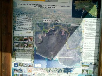
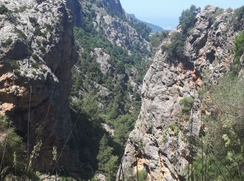
• GR221 La Ruta de Pedra en Sec. Bien balisé. Logement: Refuge de Pont Roma.
![Randonnée Marche Escorca - GR221 # Refuge Tossals Verds - Coll des Prat - Lluc - Photo](https://media.geolcdn.com/t/350/260/b38547f6-197b-471f-bae0-13e98b44e3c2.jpg&format=jpg&maxdim=2)
![Marche Marche](https://static1.geolcdn.com/sitytour/trail-icons/101.png)
Km
Marche
![](/images/other/stat-length.png)
![](https://static1.geolcdn.com/siteimages/upload/files/1508320355ic_sort_den_pos_24dp.png)
![](https://static1.geolcdn.com/siteimages/upload/files/1508320355ic_sort_den_neg_24dp.png)
![](https://static1.geolcdn.com/siteimages/upload/files/16400158638029165_repeat_loop_refresh_sync_direction_icon.png)
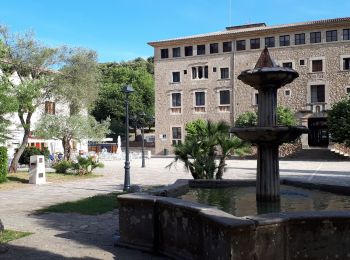
• GR221 La Ruta de Pedra en Sec Bien balisé Logement: Santuari de Lluc ou refuge de Son Amer 20mins plus loin. Possib...
![Randonnée Marche Sóller - GR221 # Soller - Pas Llis - Refuge Tossals Verds - Photo](https://media.geolcdn.com/t/350/260/e8d28a15-8241-4fba-8d38-462bd75ed5d3.jpeg&format=jpg&maxdim=2)
![Marche Marche](https://static1.geolcdn.com/sitytour/trail-icons/101.png)
Km
Marche
![](/images/other/stat-length.png)
![](https://static1.geolcdn.com/siteimages/upload/files/1508320355ic_sort_den_pos_24dp.png)
![](https://static1.geolcdn.com/siteimages/upload/files/1508320355ic_sort_den_neg_24dp.png)
![](https://static1.geolcdn.com/siteimages/upload/files/16400158638029165_repeat_loop_refresh_sync_direction_icon.png)
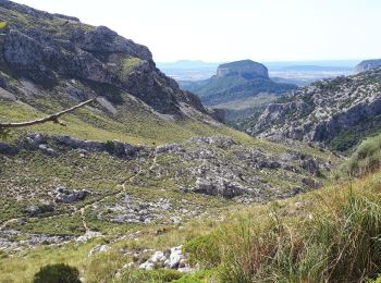
• GR221 La Ruta de Pedra en Sec Bien balisé Il y a un vieux Tram entre le port et Soller, compter 30 minutes. Passage...
20 randonnées affichées sur 275
Application GPS de randonnée GRATUITE
Activités
Régions proches
- Alaior
- Alaró
- Alcúdia
- Andratx
- Artà
- Banyalbufar
- Bunyola
- Calvià
- Campos
- Capdepera
- Citadelle
- Deià
- Es Mercadal
- Escorca
- Esporles
- Estellencs
- Felanitx
- Ferreries
- Formentera
- Fornalutx
- Ibiza
- Inca
- Lloseta
- Llucmajor
- Manacor
- Mancor de la Vall
- Maó
- Maria de la Salut
- Marratxí
- Muro
- Petra
- Pollença
- Puigpunyent
- Sant Antoni de Portmany
- Sant Joan de Labritja
- Sant Josep de sa Talaia
- Sant Llorenç des Cardassar
- Sant Lluís
- Santa Eulària des Riu
- Santa Margalida
- Santa María del Camí
- Santanyí
- Selva
- Sineu
- Sóller
- Valldemossa
- es Castell
- es Migjorn Gran
- sa Pobla
- ses Salines