![](/images/other/stat-length.png)
- Randonnées
- Outdoor
- Espagne
- Catalogne
- Tarragone
- la Torre de Fontaubella
la Torre de Fontaubella, Tarragone : Les meilleures randonnées, itinéraires, parcours, balades et promenades
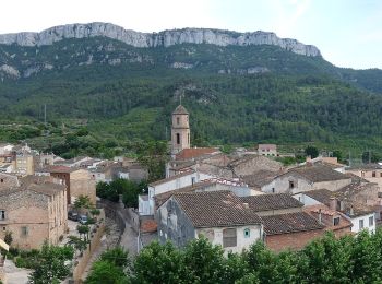
la Torre de Fontaubella : découvrez les meilleures randonnées : 3 pédestres. Tous ces circuits, parcours, itinéraires et activités en plein air sont disponibles dans nos applications SityTrail pour smartphones et tablettes.
Les meilleurs parcours (3)
![Randonnée A pied la Torre de Fontaubella - Una fortalesa de pedra i roca - Photo](https://media.geolcdn.com/t/350/260/ab9e55d4-9762-436f-bbdd-506f05934381.jpeg&format=jpg&maxdim=2)
![A pied A pied](https://static1.geolcdn.com/sitytour/trail-icons/100.png)
Km
A pied
![](/images/other/stat-length.png)
![](https://static1.geolcdn.com/siteimages/upload/files/1508320355ic_sort_den_pos_24dp.png)
![](https://static1.geolcdn.com/siteimages/upload/files/1508320355ic_sort_den_neg_24dp.png)
![](https://static1.geolcdn.com/siteimages/upload/files/16400158638029165_repeat_loop_refresh_sync_direction_icon.png)
• Site web: https://www.turismepriorat.org/ca/una-fortalesa-de-pedra-i-roca
![Randonnée A pied la Torre de Fontaubella - De la torre de Fontaubella a Llaberia - Photo](https://media.geolcdn.com/t/350/260/bd20b568-a234-486f-8409-8a133980e5fa.jpeg&format=jpg&maxdim=2)
![A pied A pied](https://static1.geolcdn.com/sitytour/trail-icons/100.png)
Km
A pied
![](/images/other/stat-length.png)
![](https://static1.geolcdn.com/siteimages/upload/files/1508320355ic_sort_den_pos_24dp.png)
![](https://static1.geolcdn.com/siteimages/upload/files/1508320355ic_sort_den_neg_24dp.png)
![](https://static1.geolcdn.com/siteimages/upload/files/16400158638029165_repeat_loop_refresh_sync_direction_icon.png)
• Site web: https://www.turismepriorat.org/ca/la-torre-de-fontaubella-llaberia
![Randonnée Marche la Torre de Fontaubella - moka de coldejou - Photo](https://media.geolcdn.com/t/350/260/ext.jpg?maxdim=2&url=https%3A%2F%2Fservices.sitytrail.com%2FGeolivesWS%2FDownloadMedia.ashx%3FTrailID%3D551835%26Media%3Dfix__20160313132447.jpg)
![Marche Marche](https://static1.geolcdn.com/sitytour/trail-icons/101.png)
Km
Marche
![](/images/other/stat-length.png)
![](https://static1.geolcdn.com/siteimages/upload/files/1508320355ic_sort_den_pos_24dp.png)
![](https://static1.geolcdn.com/siteimages/upload/files/1508320355ic_sort_den_neg_24dp.png)
![](https://static1.geolcdn.com/siteimages/upload/files/16400158638029165_repeat_loop_refresh_sync_direction_icon.png)
• aller sentier de montagne escarpé retour par des pentes moins raides.
3 randonnées affichées sur 3
Application GPS de randonnée GRATUITE