![](/images/other/stat-length.png)
- Randonnées
- Outdoor
- Autriche
- Basse-Autriche
- Bezirk Baden
- Gemeinde Pfaffstätten
Gemeinde Pfaffstätten, Bezirk Baden : Les meilleures randonnées, itinéraires, parcours, balades et promenades
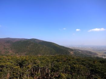
Gemeinde Pfaffstätten : découvrez les meilleures randonnées : 8 pédestres. Tous ces circuits, parcours, itinéraires et activités en plein air sont disponibles dans nos applications SityTrail pour smartphones et tablettes.
Les meilleurs parcours (8)
![Randonnée A pied Gemeinde Pfaffstätten - Zierfandlerweg - Photo](https://media.geolcdn.com/t/350/260/af74b940-6bd6-464b-b4e2-a016a93d9e68.jpeg&format=jpg&maxdim=2)
![A pied A pied](https://static1.geolcdn.com/sitytour/trail-icons/100.png)
Km
A pied
![](/images/other/stat-length.png)
![](https://static1.geolcdn.com/siteimages/upload/files/1508320355ic_sort_den_pos_24dp.png)
![](https://static1.geolcdn.com/siteimages/upload/files/1508320355ic_sort_den_neg_24dp.png)
![](https://static1.geolcdn.com/siteimages/upload/files/16400158638029165_repeat_loop_refresh_sync_direction_icon.png)
• Randonnée créée par Fremdenverkehrsverein Pfaffstätten. Symbole: rotes Schild, schwarzer Pfeil, Zierfandlerweg
![Randonnée A pied Gemeinde Pfaffstätten - Neuburgerweg - Photo](https://media.geolcdn.com/t/350/260/92132fff-2a56-4d75-9f8f-386ecb33f178.jpeg&format=jpg&maxdim=2)
![A pied A pied](https://static1.geolcdn.com/sitytour/trail-icons/100.png)
Km
A pied
![](/images/other/stat-length.png)
![](https://static1.geolcdn.com/siteimages/upload/files/1508320355ic_sort_den_pos_24dp.png)
![](https://static1.geolcdn.com/siteimages/upload/files/1508320355ic_sort_den_neg_24dp.png)
![](https://static1.geolcdn.com/siteimages/upload/files/16400158638029165_repeat_loop_refresh_sync_direction_icon.png)
• Randonnée créée par Fremdenverkehrsverein Pfaffstätten. Symbole: gelbes Schild, blauer Pfeil, Neuburgerweg
![Randonnée A pied Gemeinde Pfaffstätten - Les'Hanl Erlebnispfad - Photo](https://media.geolcdn.com/t/350/260/7339aca9-9253-4fc9-a99a-204f444db88d.jpeg&format=jpg&maxdim=2)
![A pied A pied](https://static1.geolcdn.com/sitytour/trail-icons/100.png)
Km
A pied
![](/images/other/stat-length.png)
![](https://static1.geolcdn.com/siteimages/upload/files/1508320355ic_sort_den_pos_24dp.png)
![](https://static1.geolcdn.com/siteimages/upload/files/1508320355ic_sort_den_neg_24dp.png)
![](https://static1.geolcdn.com/siteimages/upload/files/16400158638029165_repeat_loop_refresh_sync_direction_icon.png)
• Randonnée créée par Fremdenverkehrsverein Pfaffstätten.
![Randonnée A pied Gemeinde Pfaffstätten - Föhrenweg - Photo](https://media.geolcdn.com/t/350/260/da75a7b9-4f9d-44b7-bfba-c4c3519d2422.jpeg&format=jpg&maxdim=2)
![A pied A pied](https://static1.geolcdn.com/sitytour/trail-icons/100.png)
Km
A pied
![](/images/other/stat-length.png)
![](https://static1.geolcdn.com/siteimages/upload/files/1508320355ic_sort_den_pos_24dp.png)
![](https://static1.geolcdn.com/siteimages/upload/files/1508320355ic_sort_den_neg_24dp.png)
![](https://static1.geolcdn.com/siteimages/upload/files/16400158638029165_repeat_loop_refresh_sync_direction_icon.png)
• Randonnée créée par Fremdenverkehrsverein Pfaffstätten. Symbole: grünes Schild, blauer Pfeil, Föhrenweg
![Randonnée A pied Gemeinde Pfaffstätten - Einödweg - Photo](https://media.geolcdn.com/t/350/260/296bf79e-038d-43e1-92e4-cfdcc95f1f5b.jpeg&format=jpg&maxdim=2)
![A pied A pied](https://static1.geolcdn.com/sitytour/trail-icons/100.png)
Km
A pied
![](/images/other/stat-length.png)
![](https://static1.geolcdn.com/siteimages/upload/files/1508320355ic_sort_den_pos_24dp.png)
![](https://static1.geolcdn.com/siteimages/upload/files/1508320355ic_sort_den_neg_24dp.png)
![](https://static1.geolcdn.com/siteimages/upload/files/16400158638029165_repeat_loop_refresh_sync_direction_icon.png)
• Randonnée créée par Fremdenverkehrsverein Pfaffstätten. Symbole: graues Schild, gelber Pfeil mit Namen Einödweg
![Randonnée A pied Gemeinde Pfaffstätten - Blauer Portugieserweg - Photo](https://media.geolcdn.com/t/350/260/92132fff-2a56-4d75-9f8f-386ecb33f178.jpeg&format=jpg&maxdim=2)
![A pied A pied](https://static1.geolcdn.com/sitytour/trail-icons/100.png)
Km
A pied
![](/images/other/stat-length.png)
![](https://static1.geolcdn.com/siteimages/upload/files/1508320355ic_sort_den_pos_24dp.png)
![](https://static1.geolcdn.com/siteimages/upload/files/1508320355ic_sort_den_neg_24dp.png)
![](https://static1.geolcdn.com/siteimages/upload/files/16400158638029165_repeat_loop_refresh_sync_direction_icon.png)
• Randonnée créée par Fremdenverkehrsverein Pfaffstätten. Symbole: blaues Schild, gelber Pfeil, Blauer Portugieserweg
![Randonnée A pied Gemeinde Pfaffstätten - tut-gut-Wanderweg Pfaffstätten Route3 - Photo](https://media.geolcdn.com/t/350/260/c4cb8e24-215c-441d-aa81-6d7f3a615d47.jpeg&format=jpg&maxdim=2)
![A pied A pied](https://static1.geolcdn.com/sitytour/trail-icons/100.png)
Km
A pied
![](/images/other/stat-length.png)
![](https://static1.geolcdn.com/siteimages/upload/files/1508320355ic_sort_den_pos_24dp.png)
![](https://static1.geolcdn.com/siteimages/upload/files/1508320355ic_sort_den_neg_24dp.png)
![](https://static1.geolcdn.com/siteimages/upload/files/16400158638029165_repeat_loop_refresh_sync_direction_icon.png)
![Randonnée A pied Gemeinde Pfaffstätten - Tut gut! Schritteweg Pfaffstätten - Photo](https://media.geolcdn.com/t/350/260/7339aca9-9253-4fc9-a99a-204f444db88d.jpeg&format=jpg&maxdim=2)
![A pied A pied](https://static1.geolcdn.com/sitytour/trail-icons/100.png)
Km
A pied
![](/images/other/stat-length.png)
![](https://static1.geolcdn.com/siteimages/upload/files/1508320355ic_sort_den_pos_24dp.png)
![](https://static1.geolcdn.com/siteimages/upload/files/1508320355ic_sort_den_neg_24dp.png)
![](https://static1.geolcdn.com/siteimages/upload/files/16400158638029165_repeat_loop_refresh_sync_direction_icon.png)
8 randonnées affichées sur 8
Application GPS de randonnée GRATUITE