![](/images/other/stat-length.png)
- Randonnées
- A pied
- Luxembourg
- Inconnu
- Canton Esch-sur-Alzette
Canton Esch-sur-Alzette, Inconnu, A pied : Les meilleures randonnées, itinéraires, parcours, balades et promenades
Canton Esch-sur-Alzette : découvrez les meilleures randonnées : 38 a pied, 65 marche et 1 marche nordique. Tous ces circuits, parcours, itinéraires et activités en plein air sont disponibles dans nos applications SityTrail pour smartphones et tablettes.
Les meilleurs parcours (104)
![Randonnée A pied Esch-sur-Alzette - Sentier Pierre Wiess - Photo](https://media.geolcdn.com/t/350/260/fb7503a0-8edc-4589-a05b-6ac952d1b3b6.jpeg&format=jpg&maxdim=2)
![A pied A pied](https://static1.geolcdn.com/sitytour/trail-icons/100.png)
Km
A pied
![](/images/other/stat-length.png)
![](https://static1.geolcdn.com/siteimages/upload/files/1508320355ic_sort_den_pos_24dp.png)
![](https://static1.geolcdn.com/siteimages/upload/files/1508320355ic_sort_den_neg_24dp.png)
![](https://static1.geolcdn.com/siteimages/upload/files/16400158638029165_repeat_loop_refresh_sync_direction_icon.png)
• Site web: https://citylife.esch.lu/circuits_autopedestres/
![Randonnée A pied Pétange - Auto-Pédestre Pétange - Photo](https://media.geolcdn.com/t/350/260/3bda8901-8a45-455f-a0d9-28619ac75e15.jpeg&format=jpg&maxdim=2)
![A pied A pied](https://static1.geolcdn.com/sitytour/trail-icons/100.png)
Km
A pied
![](/images/other/stat-length.png)
![](https://static1.geolcdn.com/siteimages/upload/files/1508320355ic_sort_den_pos_24dp.png)
![](https://static1.geolcdn.com/siteimages/upload/files/1508320355ic_sort_den_neg_24dp.png)
![](https://static1.geolcdn.com/siteimages/upload/files/16400158638029165_repeat_loop_refresh_sync_direction_icon.png)
• Randonnée créée par Ministère de l´Économie. Site web: https://map.geoportail.lu/theme/tourisme?fid=176_2734581
![Randonnée A pied Schifflange - Auto-Pédestre Schifflange - Photo](https://media.geolcdn.com/t/350/260/6e4f4de8-0f99-4558-801f-ac0feb96d3b3.jpeg&format=jpg&maxdim=2)
![A pied A pied](https://static1.geolcdn.com/sitytour/trail-icons/100.png)
Km
A pied
![](/images/other/stat-length.png)
![](https://static1.geolcdn.com/siteimages/upload/files/1508320355ic_sort_den_pos_24dp.png)
![](https://static1.geolcdn.com/siteimages/upload/files/1508320355ic_sort_den_neg_24dp.png)
![](https://static1.geolcdn.com/siteimages/upload/files/16400158638029165_repeat_loop_refresh_sync_direction_icon.png)
• Randonnée créée par Ministère de l´Économie. Site web: https://map.geoportail.lu/theme/tourisme?fid=176_3747737
![Randonnée A pied Mondercange - Auto-Pédestre Mondercange - Photo](https://media.geolcdn.com/t/350/260/d05d3548-a873-4391-961b-2b736352f0a8.jpeg&format=jpg&maxdim=2)
![A pied A pied](https://static1.geolcdn.com/sitytour/trail-icons/100.png)
Km
A pied
![](/images/other/stat-length.png)
![](https://static1.geolcdn.com/siteimages/upload/files/1508320355ic_sort_den_pos_24dp.png)
![](https://static1.geolcdn.com/siteimages/upload/files/1508320355ic_sort_den_neg_24dp.png)
![](https://static1.geolcdn.com/siteimages/upload/files/16400158638029165_repeat_loop_refresh_sync_direction_icon.png)
• Randonnée créée par Ministère de l´Économie. Site web: https://map.geoportail.lu/theme/tourisme?fid=176_3625304
![Randonnée A pied Esch-sur-Alzette - Auto-Pédestre Esch-sur-Alzette - Photo](https://media.geolcdn.com/t/350/260/b5c02b78-1f2a-4286-8a45-2a22bbfe4d56.jpeg&format=jpg&maxdim=2)
![A pied A pied](https://static1.geolcdn.com/sitytour/trail-icons/100.png)
Km
A pied
![](/images/other/stat-length.png)
![](https://static1.geolcdn.com/siteimages/upload/files/1508320355ic_sort_den_pos_24dp.png)
![](https://static1.geolcdn.com/siteimages/upload/files/1508320355ic_sort_den_neg_24dp.png)
![](https://static1.geolcdn.com/siteimages/upload/files/16400158638029165_repeat_loop_refresh_sync_direction_icon.png)
• Randonnée créée par Ministère de l´Économie. Site web: https://map.geoportail.lu/theme/tourisme?fid=176_3799343
![Randonnée A pied Pétange - Auto-Pédestre Lamadelaine - Photo](https://media.geolcdn.com/t/350/260/b8abde83-d7ee-4d08-8b56-7c6d44fc17fc.jpeg&format=jpg&maxdim=2)
![A pied A pied](https://static1.geolcdn.com/sitytour/trail-icons/100.png)
Km
A pied
![](/images/other/stat-length.png)
![](https://static1.geolcdn.com/siteimages/upload/files/1508320355ic_sort_den_pos_24dp.png)
![](https://static1.geolcdn.com/siteimages/upload/files/1508320355ic_sort_den_neg_24dp.png)
![](https://static1.geolcdn.com/siteimages/upload/files/16400158638029165_repeat_loop_refresh_sync_direction_icon.png)
• Randonnée créée par Ministère de l´Économie. Site web: https://map.geoportail.lu/theme/tourisme?fid=176_4648388
![Randonnée A pied Bettembourg - Auto-Pédestre Abweiler - Photo](https://media.geolcdn.com/t/350/260/1c3b9107-b18f-49ca-b7ac-5bad22cb255c.jpeg&format=jpg&maxdim=2)
![A pied A pied](https://static1.geolcdn.com/sitytour/trail-icons/100.png)
Km
A pied
![](/images/other/stat-length.png)
![](https://static1.geolcdn.com/siteimages/upload/files/1508320355ic_sort_den_pos_24dp.png)
![](https://static1.geolcdn.com/siteimages/upload/files/1508320355ic_sort_den_neg_24dp.png)
![](https://static1.geolcdn.com/siteimages/upload/files/16400158638029165_repeat_loop_refresh_sync_direction_icon.png)
• Randonnée créée par Ministère de l´Économie. Site web: https://map.geoportail.lu/theme/tourisme?fid=176_3091194
![Randonnée A pied Kayl - Auto-Pédestre Kayl - Photo](https://media.geolcdn.com/t/350/260/05634cbd-69a7-4685-a005-dc48af1d3e5c.jpeg&format=jpg&maxdim=2)
![A pied A pied](https://static1.geolcdn.com/sitytour/trail-icons/100.png)
Km
A pied
![](/images/other/stat-length.png)
![](https://static1.geolcdn.com/siteimages/upload/files/1508320355ic_sort_den_pos_24dp.png)
![](https://static1.geolcdn.com/siteimages/upload/files/1508320355ic_sort_den_neg_24dp.png)
![](https://static1.geolcdn.com/siteimages/upload/files/16400158638029165_repeat_loop_refresh_sync_direction_icon.png)
• Randonnée créée par Ministère de l´Èconomie. Site web: https://map.geoportail.lu/theme/tourisme?fid=176_4648411
![Randonnée A pied Dudelange - Auto-Pédestre Dudelange 1 - Photo](https://media.geolcdn.com/t/350/260/4604b46c-e658-438b-bbb1-3c17c8ec28c2.jpeg&format=jpg&maxdim=2)
![A pied A pied](https://static1.geolcdn.com/sitytour/trail-icons/100.png)
Km
A pied
![](/images/other/stat-length.png)
![](https://static1.geolcdn.com/siteimages/upload/files/1508320355ic_sort_den_pos_24dp.png)
![](https://static1.geolcdn.com/siteimages/upload/files/1508320355ic_sort_den_neg_24dp.png)
![](https://static1.geolcdn.com/siteimages/upload/files/16400158638029165_repeat_loop_refresh_sync_direction_icon.png)
• Randonnée créée par Ministère de l´Économie. Site web: https://map.geoportail.lu/theme/tourisme?fid=176_4250936
![Randonnée A pied Dudelange - Auto-Pédestre Dudelange 2 - Photo](https://media.geolcdn.com/t/350/260/af1bad0c-3221-4446-bdc1-63f6fbf66e3d.jpeg&format=jpg&maxdim=2)
![A pied A pied](https://static1.geolcdn.com/sitytour/trail-icons/100.png)
Km
A pied
![](/images/other/stat-length.png)
![](https://static1.geolcdn.com/siteimages/upload/files/1508320355ic_sort_den_pos_24dp.png)
![](https://static1.geolcdn.com/siteimages/upload/files/1508320355ic_sort_den_neg_24dp.png)
![](https://static1.geolcdn.com/siteimages/upload/files/16400158638029165_repeat_loop_refresh_sync_direction_icon.png)
• Randonnée créée par Ministère de l´Économie. Site web: https://map.geoportail.lu/theme/tourisme?fid=176_4648243
![Randonnée A pied Leudelange - Auto-Pédestre Roedgen - Photo](https://media.geolcdn.com/t/350/260/4387dfb8-6c80-4acc-9a37-ef44c95f5b0e.jpeg&format=jpg&maxdim=2)
![A pied A pied](https://static1.geolcdn.com/sitytour/trail-icons/100.png)
Km
A pied
![](/images/other/stat-length.png)
![](https://static1.geolcdn.com/siteimages/upload/files/1508320355ic_sort_den_pos_24dp.png)
![](https://static1.geolcdn.com/siteimages/upload/files/1508320355ic_sort_den_neg_24dp.png)
![](https://static1.geolcdn.com/siteimages/upload/files/16400158638029165_repeat_loop_refresh_sync_direction_icon.png)
• Randonnée créée par Ministère de l´Économie. Site web: https://map.geoportail.lu/theme/tourisme?fid=176_1303007
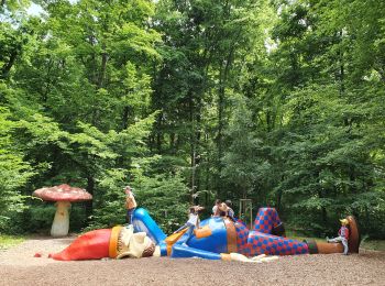
![Randonnée Marche Bettembourg - Luxembourg-Parc Merveilleux - Photo](https://media.geolcdn.com/t/350/260/e96577b3-989a-4bed-a24d-623f11b117db.jpg&format=jpg&maxdim=2)
![Marche Marche](https://static1.geolcdn.com/sitytour/trail-icons/101.png)
Km
Marche
![](/images/other/stat-length.png)
![](https://static1.geolcdn.com/siteimages/upload/files/1508320355ic_sort_den_pos_24dp.png)
![](https://static1.geolcdn.com/siteimages/upload/files/1508320355ic_sort_den_neg_24dp.png)
![](https://static1.geolcdn.com/siteimages/upload/files/16400158638029165_repeat_loop_refresh_sync_direction_icon.png)
• Superbe parc pour les enfants ! Il porte bien son nom.
![Randonnée A pied Roeser - Roeser Spazeierwee - Photo](https://media.geolcdn.com/t/350/260/4e4e36fb-20f4-484d-b0d9-21ffc0e93654.jpeg&format=jpg&maxdim=2)
![A pied A pied](https://static1.geolcdn.com/sitytour/trail-icons/100.png)
Km
A pied
![](/images/other/stat-length.png)
![](https://static1.geolcdn.com/siteimages/upload/files/1508320355ic_sort_den_pos_24dp.png)
![](https://static1.geolcdn.com/siteimages/upload/files/1508320355ic_sort_den_neg_24dp.png)
![](https://static1.geolcdn.com/siteimages/upload/files/16400158638029165_repeat_loop_refresh_sync_direction_icon.png)
![Randonnée A pied Kayl - Circuit Tétange - Photo](https://media.geolcdn.com/t/350/260/7753739c-30dc-49db-8d8b-fb1244e1177a.jpeg&format=jpg&maxdim=2)
![A pied A pied](https://static1.geolcdn.com/sitytour/trail-icons/100.png)
Km
A pied
![](/images/other/stat-length.png)
![](https://static1.geolcdn.com/siteimages/upload/files/1508320355ic_sort_den_pos_24dp.png)
![](https://static1.geolcdn.com/siteimages/upload/files/1508320355ic_sort_den_neg_24dp.png)
![](https://static1.geolcdn.com/siteimages/upload/files/16400158638029165_repeat_loop_refresh_sync_direction_icon.png)
![Randonnée A pied Esch-sur-Alzette - Promenade Architecturale - Photo](https://media.geolcdn.com/t/350/260/fc1c5986-5145-4464-8347-1dd156f13990.jpeg&format=jpg&maxdim=2)
![A pied A pied](https://static1.geolcdn.com/sitytour/trail-icons/100.png)
Km
A pied
![](/images/other/stat-length.png)
![](https://static1.geolcdn.com/siteimages/upload/files/1508320355ic_sort_den_pos_24dp.png)
![](https://static1.geolcdn.com/siteimages/upload/files/1508320355ic_sort_den_neg_24dp.png)
![](https://static1.geolcdn.com/siteimages/upload/files/16400158638029165_repeat_loop_refresh_sync_direction_icon.png)
![Randonnée A pied Differdange - Sentier du Temps Perdu - Photo](https://media.geolcdn.com/t/350/260/f2ec4c4a-e3b0-42a8-a4b9-f770a42da903.jpeg&format=jpg&maxdim=2)
![A pied A pied](https://static1.geolcdn.com/sitytour/trail-icons/100.png)
Km
A pied
![](/images/other/stat-length.png)
![](https://static1.geolcdn.com/siteimages/upload/files/1508320355ic_sort_den_pos_24dp.png)
![](https://static1.geolcdn.com/siteimages/upload/files/1508320355ic_sort_den_neg_24dp.png)
![](https://static1.geolcdn.com/siteimages/upload/files/16400158638029165_repeat_loop_refresh_sync_direction_icon.png)
![Randonnée A pied Mondercange - Sentier Dumontshaff - Photo](https://media.geolcdn.com/t/350/260/4cb67fff-f090-4611-b8cb-1383959c2944.jpeg&format=jpg&maxdim=2)
![A pied A pied](https://static1.geolcdn.com/sitytour/trail-icons/100.png)
Km
A pied
![](/images/other/stat-length.png)
![](https://static1.geolcdn.com/siteimages/upload/files/1508320355ic_sort_den_pos_24dp.png)
![](https://static1.geolcdn.com/siteimages/upload/files/1508320355ic_sort_den_neg_24dp.png)
![](https://static1.geolcdn.com/siteimages/upload/files/16400158638029165_repeat_loop_refresh_sync_direction_icon.png)
![Randonnée A pied Reckange-sur-Mess - Reckange Circuit E - Photo](https://media.geolcdn.com/t/350/260/9ceba497-1f5a-4efb-9447-86c439c7f885.jpeg&format=jpg&maxdim=2)
![A pied A pied](https://static1.geolcdn.com/sitytour/trail-icons/100.png)
Km
A pied
![](/images/other/stat-length.png)
![](https://static1.geolcdn.com/siteimages/upload/files/1508320355ic_sort_den_pos_24dp.png)
![](https://static1.geolcdn.com/siteimages/upload/files/1508320355ic_sort_den_neg_24dp.png)
![](https://static1.geolcdn.com/siteimages/upload/files/16400158638029165_repeat_loop_refresh_sync_direction_icon.png)
![Randonnée A pied Roeser - Old Fleche Bleu Berchem/Bivange - Photo](https://media.geolcdn.com/t/350/260/f7626d27-adad-48e0-b4dd-44e02457f89e.jpeg&format=jpg&maxdim=2)
![A pied A pied](https://static1.geolcdn.com/sitytour/trail-icons/100.png)
Km
A pied
![](/images/other/stat-length.png)
![](https://static1.geolcdn.com/siteimages/upload/files/1508320355ic_sort_den_pos_24dp.png)
![](https://static1.geolcdn.com/siteimages/upload/files/1508320355ic_sort_den_neg_24dp.png)
![](https://static1.geolcdn.com/siteimages/upload/files/16400158638029165_repeat_loop_refresh_sync_direction_icon.png)
![Randonnée A pied Reckange-sur-Mess - Former FB Reckange - Photo](https://media.geolcdn.com/t/350/260/be8e07cb-172b-4adc-bb9b-78ec1ba5154e.jpeg&format=jpg&maxdim=2)
![A pied A pied](https://static1.geolcdn.com/sitytour/trail-icons/100.png)
Km
A pied
![](/images/other/stat-length.png)
![](https://static1.geolcdn.com/siteimages/upload/files/1508320355ic_sort_den_pos_24dp.png)
![](https://static1.geolcdn.com/siteimages/upload/files/1508320355ic_sort_den_neg_24dp.png)
![](https://static1.geolcdn.com/siteimages/upload/files/16400158638029165_repeat_loop_refresh_sync_direction_icon.png)
20 randonnées affichées sur 104
Application GPS de randonnée GRATUITE