![](/images/other/stat-length.png)
- Randonnées
- A pied
- Italie
- Trentin-Haut-Adige
- Haut-Adige
- Welschnofen - Nova Levante
Welschnofen - Nova Levante, Haut-Adige, A pied : Les meilleures randonnées, itinéraires, parcours, balades et promenades
Welschnofen - Nova Levante : découvrez les meilleures randonnées : 4 a pied et 2 marche. Tous ces circuits, parcours, itinéraires et activités en plein air sont disponibles dans nos applications SityTrail pour smartphones et tablettes.
Les meilleurs parcours (6)
![Randonnée A pied Welschnofen - Nova Levante - (SI C16N) Bivio Rifugio Coronelle - San Cipriano Tires - Photo](https://media.geolcdn.com/t/350/260/11658389-d649-45f4-beaf-2028cacd09ab.jpeg&format=jpg&maxdim=2)
![A pied A pied](https://static1.geolcdn.com/sitytour/trail-icons/100.png)
Km
A pied
![](/images/other/stat-length.png)
![](https://static1.geolcdn.com/siteimages/upload/files/1508320355ic_sort_den_pos_24dp.png)
![](https://static1.geolcdn.com/siteimages/upload/files/1508320355ic_sort_den_neg_24dp.png)
![](https://static1.geolcdn.com/siteimages/upload/files/16400158638029165_repeat_loop_refresh_sync_direction_icon.png)
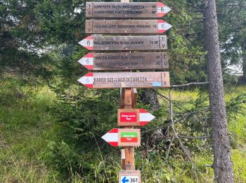
• Sentiero Italia CAI 2019
![Randonnée A pied Welschnofen - Nova Levante - N01 - Photo](https://media.geolcdn.com/t/350/260/4579c508-6219-4b3b-a050-86ec929436de.jpeg&format=jpg&maxdim=2)
![A pied A pied](https://static1.geolcdn.com/sitytour/trail-icons/100.png)
Km
A pied
![](/images/other/stat-length.png)
![](https://static1.geolcdn.com/siteimages/upload/files/1508320355ic_sort_den_pos_24dp.png)
![](https://static1.geolcdn.com/siteimages/upload/files/1508320355ic_sort_den_neg_24dp.png)
![](https://static1.geolcdn.com/siteimages/upload/files/16400158638029165_repeat_loop_refresh_sync_direction_icon.png)
• Symbole: red:red:white_bar:N01:black
![Randonnée A pied Welschnofen - Nova Levante - IT-E552 - Photo](https://media.geolcdn.com/t/350/260/7083cf5a-1e2d-4127-befe-ff264928c50d.jpeg&format=jpg&maxdim=2)
![A pied A pied](https://static1.geolcdn.com/sitytour/trail-icons/100.png)
Km
A pied
![](/images/other/stat-length.png)
![](https://static1.geolcdn.com/siteimages/upload/files/1508320355ic_sort_den_pos_24dp.png)
![](https://static1.geolcdn.com/siteimages/upload/files/1508320355ic_sort_den_neg_24dp.png)
![](https://static1.geolcdn.com/siteimages/upload/files/16400158638029165_repeat_loop_refresh_sync_direction_icon.png)
• Randonnée créée par Società degli Alpinisti Tridentini. Site web: http://www.sat.tn.it/
![Randonnée Marche Welschnofen - Nova Levante - König Laurin Tour : Rosengarten et Karer See - Photo](https://media.geolcdn.com/t/350/260/2ad6e741-6fec-4822-b31f-dfab06e808ef.jpg&format=jpg&maxdim=2)
![Marche Marche](https://static1.geolcdn.com/sitytour/trail-icons/101.png)
Km
Marche
![](/images/other/stat-length.png)
![](https://static1.geolcdn.com/siteimages/upload/files/1508320355ic_sort_den_pos_24dp.png)
![](https://static1.geolcdn.com/siteimages/upload/files/1508320355ic_sort_den_neg_24dp.png)
![](https://static1.geolcdn.com/siteimages/upload/files/16400158638029165_repeat_loop_refresh_sync_direction_icon.png)
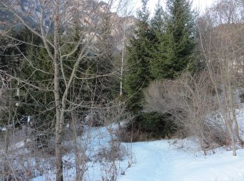
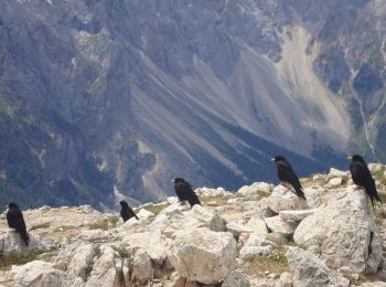
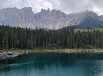
• Faite le 23/07/2023. Montée en télécabine depuis Welschnofen. Nécessite le ticket à la journée "Rosengarten Pass" pou...
![Randonnée A pied Welschnofen - Nova Levante - Dolomiti 17 - Photo](https://media.geolcdn.com/t/350/260/7083cf5a-1e2d-4127-befe-ff264928c50d.jpeg&format=jpg&maxdim=2)
![A pied A pied](https://static1.geolcdn.com/sitytour/trail-icons/100.png)
Km
A pied
![](/images/other/stat-length.png)
![](https://static1.geolcdn.com/siteimages/upload/files/1508320355ic_sort_den_pos_24dp.png)
![](https://static1.geolcdn.com/siteimages/upload/files/1508320355ic_sort_den_neg_24dp.png)
![](https://static1.geolcdn.com/siteimages/upload/files/16400158638029165_repeat_loop_refresh_sync_direction_icon.png)
• Randonnée créée par AVS Alpenverein Südtirol.
![Randonnée Marche Welschnofen - Nova Levante - Lago di carezza - Photo](https://media.geolcdn.com/t/350/260/366d5606-be7c-4a54-8c22-a358ba0d32b8.jpg&format=jpg&maxdim=2)
![Marche Marche](https://static1.geolcdn.com/sitytour/trail-icons/101.png)
Km
Marche
![](/images/other/stat-length.png)
![](https://static1.geolcdn.com/siteimages/upload/files/1508320355ic_sort_den_pos_24dp.png)
![](https://static1.geolcdn.com/siteimages/upload/files/1508320355ic_sort_den_neg_24dp.png)
![](https://static1.geolcdn.com/siteimages/upload/files/16400158638029165_repeat_loop_refresh_sync_direction_icon.png)
6 randonnées affichées sur 6
Application GPS de randonnée GRATUITE